
North Hoyle offshore windfarm situated in Liverpool Bay
(Photo © RCAHMW Crown Copyright)
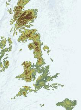
How the British Isles might appear in the distant future if global warming
and sea level rise continue, based on the results from the Benfield UCL Hazard Research Centre
(The University of Birmingham)

Dredging vessels
(Photos BMAPA)
The datasets compiled and interpreted by The University of Birmingham together with available environmental data have shown that the drowned prehistoric landscapes of Liverpool Bay and the Bristol Channel could preserve valuable sedimentary archives of long-term environmental and climatic change, and within them the archaeological remains that document the human response to that rapidly changing environment. This radically enhances the information available for the effective future management of offshore development that threatens these ancient landscapes. Aggregate extraction, petroleum exploration, trawling and windfarm construction can all damage or destroy these valuable sediments. However, by working closely with such industries, which are often an invaluable source of information, we can ensure that the utmost archaeological understanding is gained whilst seeking to promote the value of protecting this limited resource. The current concerns over global warming and the demands for ‘green’ energy have led to the investigation of both project areas for developments to harness natural forms of energy. In Liverpool Bay there are several operational wind farms and 2010 saw the approval of the £2bn Gwynt y Mor wind farm totaling 160 wind turbines situated 16km out to sea, off the north Wales coast. Although the Bristol Channel supports a single wind farm licensed area, the suggestion of a tidal barrage in the Severn Estuary has been raised several times in the recent past. This study by Dyfed Archaeological Trust, the RCAHMW and The University of Birmingham has confirmed that evidence for former ancient landscapes does exist in the areas of Liverpool Bay and the Bristol Channel. The potential for further research is vast, but this initial information is being used to produce maps showing the topographic features of the prehistoric landscapes and the potential for archaeological deposits to survive. For those managing the marine heritage these maps will form an invaluable tool when trying to assess the impact of development on these submerged landscapes, and the mitigation strategies that should be put into place to protect or record them. It is hoped that eventually all waters surrounding our coastlines will be studied and mapped in the same way. There will always be a balancing act between the merits of development, the positive benefits of reducing our carbon emissions by harnessing nature’s energy and championing the value of the ancient landscape that lies below the seabed. However, it is only by incorporating archaeological expertise into the decision making that the hundreds or even thousands of square kilometres of prehistoric landscapes will survive for future generations to appreciate as part of their heritage. |