Home > Historic Landscape Characterisation > Newport and Carningli > |

 NEWPORT
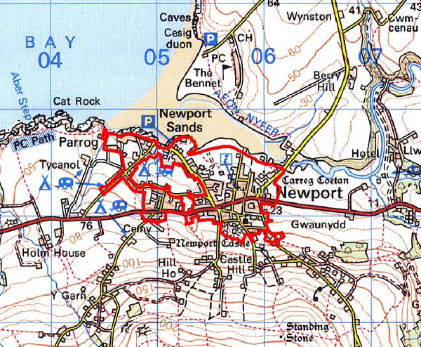
GRID REFERENCE: SN 045292
AREA IN HECTARES: 85
Historic Background
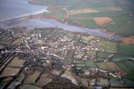
A small area of modern Pembrokeshire, comprising the built-up area of Newport town. It lies within the medieval Cantref Cemaes. Cemaes was brought under Anglo-Norman control in c.1100 by the Fitzmartins who established their castle at Nevern on the site of an iron age fort. Cemaes remained in Angle-Norman hands until 1191 when Rhys ap Gruffudd retook it. He strengthened Nevern Castle, but Welsh supremacy was short-lived for Rhys died in 1197 and in the same year William Fitzmartin regained control of Cemaes. Instead of refortifying Nevern, William established a new castle at Newport (possibly the Old Castle earthworks by the Nevern estuary) and founded a new town. In c.1241, Nicolas Fitzmartin confirmed in a charter privileges bestowed on the town by his father, William. The early years of the town were not easy for the new settlers. In 1215, Newport Castle was destroyed by Llywelyn ap Iorwerth, and the Fitzmartins did not regain control until about 1230, but in 1257 the castle was once again razed to the ground, this time by Llywelyn ap Gruffudd. By 1276-77 the castle was back in the hands of the Fitzmartins who retained it, as well as the Barony of Cemaes, until 1326, when the Audleys succeeded them. Excavation and survey have shown that the town was originally laid out with burgage plots – long building plots - along two main streets, Long Street and St Mary’s Street, with the castle now known as the Old Castle between them close to the shore of the Nevern estuary. Properties on these streets towards the estuary did not survive long, perhaps as a result of attacks by the Welsh, and by the end of the 13th century, if not earlier, these burgage plots had been abandoned and were not used again. Possibly following the attacks of 1215 or 1257 the castle was re-founded at its present site dominating he southern end of the town. A grid of new streets and the parish church of St Mary were also established in the same area. The town, however, did not flourish for in 1434 a survey lists 233 burgage plots but only 76 burgage holders. By 1594, 211 plots are recorded, but only 44 are occupied, and most of these are at the southern end of the town. Many house plots lay unused until the eve of the modern period as Richard Fenton noted the early 19th century that ‘the chasms in its depopulated streets are filling up fast with buildings’. Clearly Fenton witnessed rebuilding that is evident in the town today, represented by numerous good-quality 19th century houses. The castle, which had been in decay since the late medieval period, was re-occupied in 1859 and the gatehouse was converted into a house; other additions followed. Despite the decay evidenced in the town, Newport had several small but important industries. The town’s economy was based on agriculture, fishing and coastal trade. Newport had been the centre of a medieval and early post-medieval pottery industry, but the emergence of the town as a trading port really began in the 16th century when cloth and wool were exported. As a result, a considerable textile industry developed in the town’s hinterland. Exports also included the products of the numerous local quarries. The town was also noted for its herring fishery. Changes in the silting of the estuary caused a new quay to be established at The Parrog, with shipbuilding facilities, storehouses and limekilns. It flourished well into the 19th century - 97 vessels visited the port in 1884 - but decline set in soon afterwards. Newport has largely not developed beyond its medieval limits, but 20th century housing occupies a pocket around Cnwc-y-grogwydd, to the west of the town, the site of a medieval gallows (and possible early medieval religious site). The economy during the later 20th century has been dominated by leisure, including a yacht club on The Parrog, and tourism, with a number of caravan parks. Newport is now an attractive option for middle-class home-buyers, which has imparted a genteel aspect to the town.
Description and essential historic landscape components
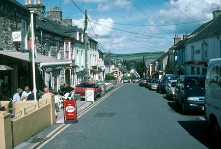
Newport historic landscape character area is mainly composed of the houses, gardens, shops, school, roads and other infrastructure of the town, but includes pockets of fields and other open ground between the built-up areas. The town lies on gentle north-facing slopes that run down to the south bank of the Nevern estuary. The medieval castle and church are located on the higher ground on the south side of the town. The core of the town is centred on the east-west A487(T) road and several narrow side-streets which form a loose grid pattern to the north and south. Parrog, situated on the estuary, is a secondary centre, which is now connected to the town proper by linear development, and there is also linear development along the A487(T) and Bridge Street to the northeast. The late 12th century – 13th century layout of the town still exerts a strong influence over modern topography, with many houses located hard against the street frontage within medieval burgage plots. The large, cruciform parish church was extensively rebuilt in the early 19th century and much of the medieval detail has been lost, except the fine 15th-16th century west tower. The castle is a single enclosure, with drum-towers and a twin-tower gatehouse, with masonry of 13th-14th century date, with 19th century additions. Apart from the parish church and the castle, almost the entire older building stock was constructed in the 19th century. This and the almost universal use of local dolerite and shale building stone provide Newport with a very strong and distinctive architectural signature. There is a fairly even mixture of cement rendered and bare stone. The render on many houses has recently been removed to reveal bare stone, usually un-coursed rubble. Close examination of this reveals that the masonry had been lime-washed prior to being covered with cement. The grey-blue and warm brown dolerite stone is normally roughly coursed, with consideration given to contrasting stone colour, and in some instances courses of slate slab give a more formal appearance to the buildings. Modern machine-cut non-local slate is the main roofing material. Within the core of the town most dwellings are in terraces. These are not single-build terraces, but rather each house has developed individually within its own burgage plot, resulting in a great range of building type from single storey vernacular cottages to three storey houses in the Georgian tradition. Two storey houses, however, dominate, with most examples in the polite ‘Georgian’ tradition, and many retaining period detailing such as porches, door cases and box-sash windows. Commercial properties including the Castle Hotel and the three–storey Llwyngwair Arms, and chapels such as the Ebenezer and Bethlehem, are of the same period and in the same building tradition as the dwellings. A similar building style and use of local stone can be found on the Parrog Road and on The Parrog itself, but here detached houses are as common as the terraces. The use of local stone in roadside and garden walls is also a notable feature of the town. Nearly all modern development is from the second half of the 20th century or later. This includes new, detached houses on the fringes of the town, and small estates of houses and bungalows at the town’s edge aa well as within the town’s historic core. Facilities to serve the local community and visiting tourists such as a library, new school, doctors’ surgery, car parks and tourist information office are located in the town. A modern yacht club is located on the stone breakwater at The Parrog and a campsite and caravan park lie on the periphery of the town. Small fields now encircled by houses provide a rural feel to parts of this area, in particular close to the estuary. These fields are of pasture and are enclosed by banks topped with often over-grown hedges. Most of the recorded archaeology is related to components of the town described above – the castle and church – or to other standing buildings such as a late 18th century mill. Other sites such as several 19th century limekilns testify to the former importance of maritime trade. Unusually for a town a neolithic chambered tomb, Carreg Coetan Authur, is a prominent historic component, although it is now somewhat overwhelmed by neighbouring modern housing.
Newport is a distinctive area, is well defined and contrasts with the neighbouring landscapes of farms and fields to the west, south and east and with the Nevern estuary to the north.
Sources: Bignall 1991; Browne and Percival 1992;
Howells 1997; Lewis 1833; Ludlow 2000; Miles 1995; Murphy 1994; Newport
Parish tithe map 1844; RCAHMW 1925
Base map reproduced from the OS map with the permission
of Ordnance Survey on behalf of The Controller of Her Majesty's Stationery
Office, © Crown Copyright 2001.
All rights reserved. Unauthorised reproduction infringes Crown Copyright
and may lead to prosecution or civil proceedings. Licence Number: GD272221