Home > Historic Landscape Characterisation > Newport and Carningli > |

 NEVERN ESTUARY
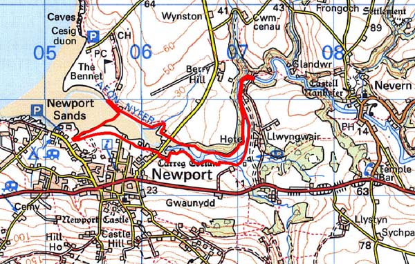
GRID REFERENCE: SN 054396
AREA IN HECTARES: 31
Historic Background
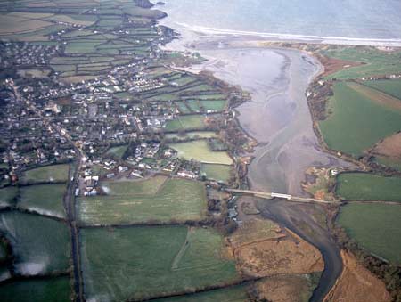
A small area of modern Pembrokeshire comprising the intertidal zone of the estuary of the River Nevern (Afon Nyfer). It lies within the medieval Cantref Cemaes. Cemaes was brought under Anglo-Norman control in c.1100 by the Fitzmartins who retained it, as the Barony of Cemaes, until 1326, when they were succeeded by the Audleys. The Barony was coterminous with the later Hundred of Cemais, which was created in 1536, but many feudal rights and obligations persisted, some until as late as 1922. This character area mainly comprises mud flats but also includes pockets of salt-marsh, which have been used for rough grazing into the modern period. It was regarded as manorial waste, and in 1278 Nicholas Fitzmartin issued a charter which granted the burgesses of Newport right of common grazing over ‘all the marshland on both sides of the River Nevern as far as the bridge…. and the small island which is between the said bridge and the lord’s mill (by the castle) which is called New Mill’. A bridge still crosses the estuary, carrying an unclassified road. It would have formerly linked the borough of Newport to the Fitzmartin demesne lands at Berry Hill. In 1598, it was described as stone-built, with six arches, but it was apparently demolished soon afterwards, and was replaced by stepping-stones (which still survive) and a ferry. The bridge was not rebuilt until 1894, and again was rebuilt in the 20th century. The location of the ‘New Mill’ has not been established. It is assumed that the Newport’s medieval and early post-medieval quay lay within this area, on the northern edge of the town. Newport had been the centre of a medieval and early post-medieval pottery industry, but the emergence of the town as a trading port really began in the 16th century when cloth and wool were exported. As a result, a considerable textile industry developed in the town’s hinterland. Exports also included products of the numerous local quarries. A chart of ‘Newport Bay and harbour’, drawn by Lewis Morris in 1748, shows the course of the river, the mud flats and the sand bar very much as they are today. At about this time, changes in the silting of the estuary caused the old quay to be abandoned and a new quay to be established at The Parrog, with shipbuilding facilities, storehouses and limekilns. Newport was also noted for its herring fishery, which originated during the medieval period as a common right of fishing between the mouth of the Nevern and its confluence with the Afon Clydach. Within this area; a weir ‘on the water of Nevarne’ with ‘the free fishery there’ was recorded in 1594 when it was worth 13s 4d annually, and seine-netting continued into the 20th century.
Description and essential historic landscape components
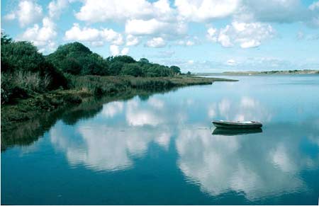
This area consists of the tidal stretches of the Nevern estuary, approximately from the banks of the river by the town of Newport to 2.2km upstream. There are no inhabited buildings in this area. Built structures consist of Newport Bridge, which has recently been rebuilt, and its approach causeway, and a 19th century limekiln. Downstream of the bridge the estuary comprises mud flats flanked by narrow strips of salt marsh and on the south bank by scrubby woodland. Upstream reed beds characterise the estuary. A salt works and a prehistoric flint-working floor have been recorded in the estuary. The Pembrokeshire Coast Path runs alongside the estuary downstream of the bridge.
This is a well-defined area. The town of Newport lies downstream of the bridge on the south bank, and rich farmland on the north bank. Upstream of the bridge steep wooded slopes and farmland flank the estuary.
Sources: Howells 1977; Miles 1995; Nevern Parish
tithe map 1843; Newport Parish tithe map 1844; Owen 1892; Rees 1932
Base map reproduced from the OS map with the permission
of Ordnance Survey on behalf of The Controller of Her Majesty's Stationery
Office, © Crown Copyright 2001.
All rights reserved. Unauthorised reproduction infringes Crown Copyright
and may lead to prosecution or civil proceedings. Licence Number: GD272221