Home > Historic Landscape Characterisation > Newport and Carningli > |

 HOLMHOUSE - TYCANOL
GRID REFERENCE: SN 043387
AREA IN HECTARES: 446
Historic Background
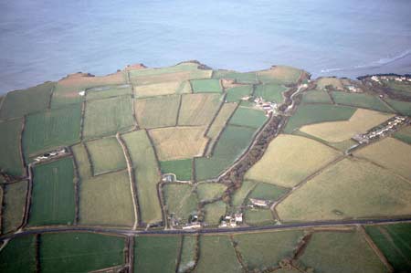
A large area of modern Pembrokeshire, comprising the coastal plain lying between Mynydd Carningli and the sea-cliffs to the north, surrounding the town of Newport. It mainly comprises long, narrow rectangular fields, of both arable and pasture. The presence of a number of monuments, including a standing stone and possible stone pair, suggest it was an important ritual landscape during the neolithic and bronze age periods, within view of Carningli hillfort, other upland monuments, and coastal sites. The area lies within the medieval Cantref Cemaes. Cemaes was brought under Anglo-Norman control in c.1100 by the Fitzmartins who retained it, as the Barony of Cemaes, until 1326, when they were succeeded by the Audleys. The Barony was coterminous with the later Hundred of Cemais, which was created in 1536, but many feudal rights and obligations persisted, some until as late as 1922. Most of this character area lay within the boundary of the borough of Newport, which, according to a charter of 1278, is more-or-less coterminous with Newport parish, and represented land over which the burgesses had right of common. The burgesses appear to have been free from rent or dues, possibly this represents a legacy from a pre-existing Welsh tenurial system. Many of the fields of this area appear to have been strip-fields, and were depicted as such on a map of 1758. At this date to the west of the town these fields were still largely unenclosed, with quillets of long narrow strips extending from the town west to the parish boundary and from the sea to one or two hundred metres south of the main A487(T). To the east of the town and in small pockets to the west amongst the strips lay small fields, the long narrow shape of which showing that they had been enclosed from blocks of several field strips. However, there is no clear evidence that these strip-fields represented arable open fields. Indeed, archaeological evaluation in 2001 revealed very shallow topsoil which did not appear to exhibit evidence of a long history of ploughing; moreover, it was recorded by Thomas Phaer, in 1552, that the Newport area was ‘bare in corn but plenty enough in cattle’. The strips may therefore represent land divisions according to native forms of tenure, as in the strip fields of the St Davids peninsula and Pen Caer. Lying centrally within the area, alongside the A487(T) – a medieval and earlier routeway – was the medieval pilgrimage chapel of Capel Dewi, but such chapels rarely appear to have been accompanied by any form of settlement. Also lying within the area are two former demesne holdings, also mentioned within the charter of 1278, both of which are surrounded by a patchwork of larger enclosures. Rhigian demesne, on the coastal plain, lies in a valley and features irregular enclosures, while Parc-y-marriage, lies on the slopes of Carningli and features more regular enclosures, which may be later in origin. Holm House, in the centre of the area, was mentioned in 1276 when it was a possession of the burgess William Pecke, of Newport; later a gentry house it has now devolved into two farms. It too lies within a pocket of small irregular fields. It seems likely that Parc-y-marriage and Holm House were established on the boundary between the strip-fields and higher unenclosed land to the south. The strip-field pattern extends into the parish of Dinas, which was a medieval knight’s fee, held of the Barony of Cemaes by Welsh tenure. Within this section is another holding, Trewreiddig, which also has a recorded medieval date and occupies a similar location to Holm House and Parc-y-marriage. It is this mixture of medieval strip-fields held by the community and demesne holdings with more regular fields that has produced the distinctive field pattern of this area. Superimposed over these earlier systems are farms founded in the 18th century such as such as Ty-canol, which carved regular-shaped, large fields out of the strip-fields. This process of enclosure and farm foundation was just about complete by the tithe survey of 1844 and has resulted in the landscape we see today.
Description and essential historic landscape components
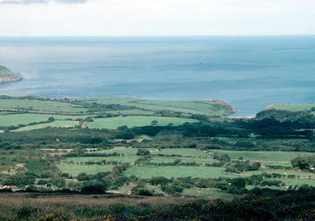
This historic landscape character area consists of an undulating coastal plain. The general trend of the land slopes from the south, from Mynydd Carningli, to the north coast. It is a landscape of fields and farms. Improved pasture is the chief agricultural land-use, with a little arable land and even less rough ground. Parts of this area are windswept, and therefore it is not characterised by trees: there are few large hedgerow standards and the only woodland comprises small, scrubby deciduous copses in sheltered hollows and valleys. Non-agricultural land-use includes campsites and caravan parks. Pockets of long narrow fields attest that parts of this area formerly comprised strip-fields. However, most fields tend towards the large and regular. Boundaries are of substantial stone-faced banks topped with hedges. Hedges are generally well maintained, with some overgrown examples in the more sheltered locations. The agricultural holdings of this area are relatively large, with the majority regularly distributed along the steeper north-facing slopes to the south of the A487(T) road which crosses from west to east. Farmhouses and other dwellings are in a variety of styles, built of local stone, but frequently cement rendered, with slate roofs, and mainly date to the 19th century. An exception is the former rectory, Gelli Olau, a substantial three-storey 18th century house in the Georgian tradition. Pen-y-feidr, the only other three-storey house in the area, is also in the polite Georgian tradition, but is mid 19th century in date. Associated with it are substantial stone-built agricultural buildings set informally around the yard. Some of these date to the early 19th century and are two-storey, others to later in the same century. There are examples of houses dating from the mid 19th century in the vernacular tradition and in the Georgian style. Twentieth century houses are also present. Most farms have one or two ranges of 19th century stone built outbuildings and 20th century steel, concrete and asbestos agricultural buildings, but these are not the dominant landscape components as found in some agricultural historic landscape areas. There are several small historic bridges along the main road, including a listed example dated 1811. Archaeological sites are numerous and varied, but do not strongly characterise the historic landscape, other than two bronze age standing stones and the neolithic chambered tomb of Carreg-y-Gof. Other sites include a holy well, the site of a dark age inscribed stone and the site of a medieval chapel.
To the north against the coastal strip and the town of Newport the definition of this area is clear. Elsewhere there is a merging of this area with its neighbours, and it is therefore not possible to define a hard-edged boundary.
Sources: Ludlow 2001; Charles 1992; Jones 1996; National
Library of Wales Llwyngwair Map 7 (1758), Map 8 (1758), Map 11 (1758);
Newport Parish tithe map 1844; Owen 1897; Pembrokeshire Record Office
HDX/18/1 (1809), HPR/33/33 (1772)
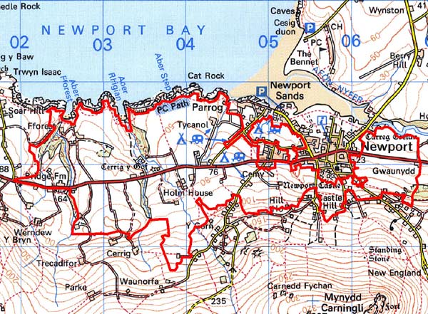
Base map reproduced from the OS map with the permission
of Ordnance Survey on behalf of The Controller of Her Majesty's Stationery
Office, © Crown Copyright 2001.
All rights reserved. Unauthorised reproduction infringes Crown Copyright
and may lead to prosecution or civil proceedings. Licence Number: GD272221