Home > Historic Landscape Characterisation > Milford Haven Area > |

MONK HAVEN TO GELLISWICK COASTAL STRIP 
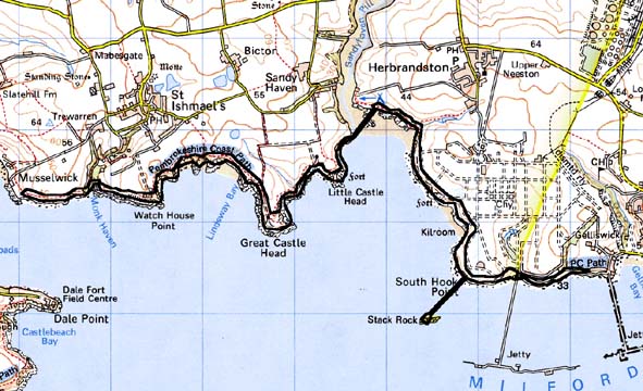
GRID REFERENCE: SM 821063
AREA IN HECTARES: 65
Historic Background
A character area comprising a narrow coastal strip situated within the
parishes of St Ishmael’s and Herbrandston. Historically, this coastal
strip has always been marginal land, outside the boundaries of cultivated
land. In the past it has been used for rough grazing, but now its main
function is as a corridor for the Pembrokeshire Coast Path, set between
farmland and the edges of the sea cliffs. However, it embraces many former
occupation sites including several iron age promontory forts. There are
few places suitable for landing small boats along this stretch of high
sea cliff. Exceptions are at Monk Haven and Sandy Haven - the latter is
dealt with in a separate area while the former was the landing place for
St Ishmael’s. Installations connected with navigation and defence
are also located within this coastal strip. Lighthouses are marked on
late 18th century estate maps on Little Castle Head, but the main periods
of construction were in the 1870s and the mid to late 20th century. The
fort on Stack Rock, originally constructed as a three gun-tower in 1850-52,
expanded to a fort in 1871, and in use until the end of World War 1 is
included in this area. During World War 2 many military installations
were constructed. The coastal strip has also witnessed mining and quarrying.
Small quarries can still be seen, but there is no trace of the copper
mines marked on 18th century maps. Twentieth century jetties from oil
tanker terminals have been constructed in the eastern part of the area.
Base map reproduced from the OS map with the permission
of Ordnance Survey on behalf of The Controller of Her Majesty's Stationery
Office, © Crown Copyright 2001.
All rights reserved. Unauthorised reproduction infringes Crown Copyright
and may lead to prosecution or civil proceedings. Licence Number: GD272221
Description and essential historic landscape components
This historic landscape character area consists of approximately an 8
km strip of high, hard-rock sea cliff topped by a narrow band of moor,
scrub and rough ground. The Pembrokeshire Coast Path runs along the entire
length of this area. Although it comprises a very narrow strip of land,
sometimes just a few metres wide, this area is very different from the
highly cultivated land and/or industrial sites that bound it. For long
sections there is no connection between the cultivated fields and/or industry
sites and the coastal strip. Essentially the historic landscape of the
coastal strip is characterised by its many and varied archaeological sites.
The most obvious and important of these are several iron age promontory
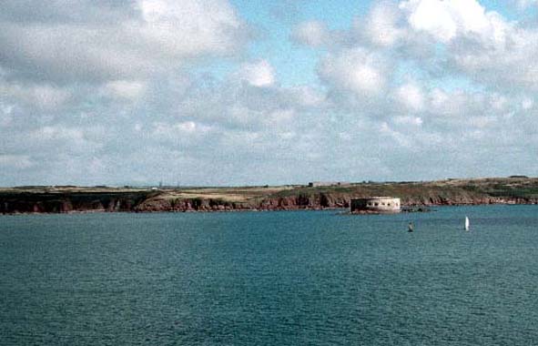
forts, such as Great Castle Head and Little Castle Head. Within the former
is the only inhabited building in the area, a lighthouse and its dwelling.
Navigation markers, both old and modern, lie in and close to Little Castle
Head. Other sites include several World war 2 coastal defence installations,
most notably gun batteries and searchlight batteries, sites of quarries
and mines, prehistoric flint working floors and an early medieval cemetery
near St Ishmael’s. The gun batteries, in particular Soldier’s
Rock, are highly visible components of the historic landscape. The prominent
offshore 19th century fort of Stack Rock has been included in this area.
This is a very distinct and well-defined area. It has hard-edged boundaries with the farmland and industrial sites that lie inland of it.
Sources: Crane 1994; Murphy and Allen 1998; Hague 1994