Home > Historic Landscape Characterisation > Milford Haven Area > |

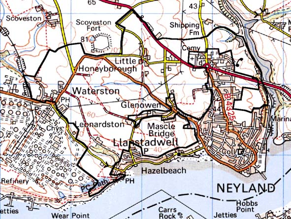
WATERSTON - HONEYBOROUGH 
GRID REFERENCE: SM 950057
AREA IN HECTARES: 377
Historic Background
This area lies on the north side of the Milford Haven waterway, within
Llanstadwell parish. It comprises two main land-holdings: Waterston and
Honeyborough. The medieval manor of Waterston was a mesne lordship of
the Lordship of Haverford, now represented by the village of Waterston.
The Manor of Honeyborough comprised one knight’s fee directly held
of the Earls of Pembroke as their share of the Lordship of Haverford,
and 2½ carucates held of the Barony of Walwyn’s Castle ‘by
homage’. Its manorial centre was at Great Honeyborough farm, located
in a neighbouring landscape character area. In c.1600 this manor was shared
between the Perrot, Bowen and Scourfield families, and then by the Batemans
and the Taskers. After 1810, farming tenants held it. Part of this area
includes the former open fields of Great Honeyborough which are shown
in operation on late 18th century estate maps. Enclosed strip fields,
evidence of a former open field system, are also shown on tithe maps at
Little Honeyborough and at Waterston. It is likely, that as at Great Honeyborough,
open fields were in use at these locations up to the 18th century. On
the tithe maps, Little Honeyborough is shown as a hamlet and Waterston
as a small nucleated village. Since the tithe survey Neyland has expanded
across the former open fields of Great Honeyborough incorporating the
village into the town. A narrow band of fields to the north of the town
is all that is left. In the 20th century the construction of an oil refinery
removed all the fields to the south of Waterston village.
Base map reproduced from the OS map with the permission
of Ordnance Survey on behalf of The Controller of Her Majesty's Stationery
Office, © Crown Copyright 2001.
All rights reserved. Unauthorised reproduction infringes Crown Copyright
and may lead to prosecution or civil proceedings. Licence Number: GD272221
Description and essential historic landscape components
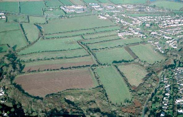
This small historic landscape character area consists of the remains of
enclosed strip fields that survive to the north of Neyland and to the
north of a large oil refinery, together with the village of Waterston
and the hamlet of Little Honeyborough. Enclosed strip fields (former open
fields) characterise the agricultural landscape of this area. These are
best preserved to the north and east of Neyland and to the north of Waterston.
Boundaries are earth banks topped with hedges. Hedges are generally in
a good condition, but a few are derelict and some are becoming overgrown.
There are a few trees, but apart from on steeper slopes woodland is not
a strong characteristic of this area. Land-use is mainly improved pasture
with a little arable. Wasterston is a nucleated village with mainly 19th
century, two storey, stone built houses and terraces in the vernacular
tradition. Modern dwellings are also present. An oil refinery lies immediately
against the southern edge of the village, and an industrial estate lies
to the west. Little Honeyborough is a very small settlement comprising
19th century two storey houses in the vernacular tradition, single storey
19th century cottages and a chapel. The few farms dispersed across the
area and within the village and hamlet are relatively small, with 19th
century houses, one or two ranges of 19th century stone-built outbuildings
and a collection of modern outbuildings. Archaeological sites are limited
and consist of a bronze age standing stone, a bronze age burnt mound and
some small post-medieval quarries. There are no listed buildings.
To the west, east and south against an oil refinery and the town of Neyland this area has very well defined boundaries. To the north boundary definition is not clear, and there is a gradual merging of this area with it neighbour.
Sources: Jones 1996; Llanstadwell Parish tithe map 1849; Llanstadwell
Third Part tithe map 1830; NLW PICTON CASTLE VOL 1; NLW MORGAN-RICHARDSON
DEPOSIT NO 1; Owen 1911; Owen 1918