Home > Historic Landscape Characterisation > Milford Haven Area > |

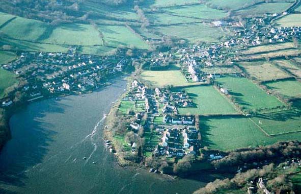
LLANGWM 
GRID REFERENCE: SM 991093
AREA IN HECTARES: 62
Historic Background
A small character area occupying the upper reaches if the Milford Haven
waterway, comprising the settlement of Llangwm. It lies within the parish
of Llangwm that is probably coterminous with the medieval mesne lordship
of Llangwm. This was a holding of the de Vales until a Roche kinsman,
Gilbert de la Roche, acquired it in the late 13th century. Its relationship
with the Lordship of Haverford, within which it lay, was always a matter
of dispute. The manor later descended, through inheritance, to the Longuevilles,
the Ferrers and the 16th century Earl of Essex. There is no evidence for
the location of the manorial centre, but in c.1600 Llangwm was one of
George Owen’s ‘woods of divers gentlemen sufficient to serve
their houses of fuel and some for buildings’, most of which probably
lay outside this area. The medieval vill appears, like the present settlement,
to have clustered around the parish church, which was not listed in 1291
and may have been a new foundation of the early 14th century. By the mid
19th century, on the tithe map, Llangwm village consisted of a small nucleation
centred on the parish church. Long narrow fields, an enclosed former open
field system, surrounded the village. A secondary, small cluster of dwellings
lay at Black Tar. During the second half of the 19th century and the early
20th century the village expanded considerably, particular around Llangwm
Pill, in order to serve the growing coal mining industry of the area.
Later 20th century and 21st century housing development has led to further
expansion of the village.
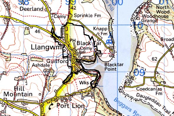
Base map reproduced from the OS map with the permission
of Ordnance Survey on behalf of The Controller of Her Majesty's Stationery
Office, © Crown Copyright 2001.
All rights reserved. Unauthorised reproduction infringes Crown Copyright
and may lead to prosecution or civil proceedings. Licence Number: GD272221
Description and essential historic landscape components
Llangwm historic landscape character area essentially comprises the village
of Llangwm and Black Tar, the foreshore and those neighbouring fields
that retain strip field characteristics – the remains of Llangwm’s
former open fields. The historic core of the village is centred on the
Grade B listed medieval parish church of St Jerome and the village green
or square. Clustered around the green are 19th century cottages and houses,
with most examples in the vernacular tradition of the area – stone
built and cement rendered, slate roofed and mainly of three bays. A 19th
century chapel stands on one side of the green, and stone-built farm buildings
both here and elsewhere lend an agricultural aspect to the settlement.
Houses fronting streets on the approaches to the green and close to Llangwm
Pill are in a variety of styles, including terraces of late 19th century
stone-built houses and small, detached 19th century and early 20th century
houses. A second chapel is situated away from the historic core of the
village. Modern housing, including small housing estates, lies on the
fringes of the village to the north, south and east. The use of brick
in a small terrace of late 19th century houses at Edward’s Pill
is unusual for this part of Pembrokeshire. There are several landing places
and access points onto the muddy and rocky foreshore, but little in the
way of formal quays or jetties. There is virtually nothing on the foreshore
that indicates Llangwm was an important port for the export of coal. Facilities
for tourism and leisure activities, particularly water-sports, are a component
of the area, with a caravan park, car parks and public toilets available.
Banks topped with hedges surround several small fields close to the village
within this area. Hedges are generally in good condition, although some
are becoming overgrown. Land-use is mostly improved pasture. Archaeology
is not a strong component of the historic landscape, but includes the
site of a mill and the site of a medieval settlement.
Llangwm is a fairly well defined historic landscape character area. Its developed nature is in contrast to the neighbouring farms and fields. However, the exact boundary between the fields of this area and those of its neighbours is not easy to define. Here there is a zone of change rather than a hard-edged border.
Sources: Llangwm Parish tithe map 1841; Ludlow 1998; Owen 1897; Rees
1975