Home > Historic Landscape Characterisation > Milford Haven Area > |

LIDDESTON 
GRID REFERENCE: SM 885063
AREA IN HECTARES: 208
Historic Background
A character area situated on the north shore of the Milford Haven waterway
lies almost entirely within the old ecclesiastical parish of Hubberston,
but now partly within Milford Haven parish. It occupies the medieval Manor
of Pill, part of the larger Manor of Pill and Roch that was created between
1100 and 1130, whose relationship with the Lordship of Haverford, within
which it lay, was always a matter of dispute. Pill was a large and important
manor, encompassing the modern town of Milford Haven. Successive Lords
of the Manor granted much of the land within this area to the late 12th
century Tironian Pill Priory, and the priory fish- or mill-pond lies here.
Settlement in this area comprises two large farms or hamlets. The first,
Liddeston, was a medieval vill that was granted to Pill Priory, as ‘Lidden’s
township’, in the mid 13th century. The Barlows of Slebech in the
16th century acquired it, with the priory. The second, Gelliswick, and
its former rabbit warren, have long been thought to be associated with
the priory. However, the place-name is not recorded until 1539 and appears
to derive from the Gely family, who provided rectors of Hubberston in
the 15th century. There is no evidence that its former windmill was associated
with Pill Priory. The Barretts, the major landowners in the area, held
it in the 16th century, and later the Philipps of Picton Castle. Two distinct
landscapes are depicted on mid 18th century estate maps. These maps show
the hamlet at Liddeston surrounded by enclosed strip fields, which had
clearly evolved from an open field system. The date of enclosure is unknown,
but is likely to have been in the 17th century and 18th century. In contrast
maps show an estate landscape of large fields centred on the post-medieval
mansion of Gelliswick with its gardens and orchards. Apart from the degradation
of individual historic landscape components the overall landscape around
Liddeston has not dramatically altered. Gelliswick has, however, undergone
vast changes. An oil refinery was built across much of its former land
in the late 1950s, the mansion and associated buildings were demolished
in 1981, and land not taken by the refinery is now a golf course.
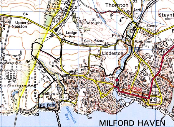
Base map reproduced from the OS map with the permission
of Ordnance Survey on behalf of The Controller of Her Majesty's Stationery
Office, © Crown Copyright 2001.
All rights reserved. Unauthorised reproduction infringes Crown Copyright
and may lead to prosecution or civil proceedings. Licence Number: GD272221
Description and essential historic landscape components
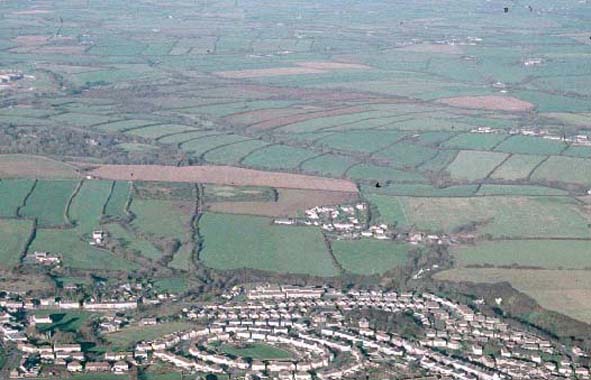
This is a relatively small historic landscape character area lying to
the west and north of the town of Milford Haven and to the east of a dismantled
oil refinery. Its southern part runs down to the sea at Gelliswick Bay.
To the north it comprises undulating farmland between 30m and 60m above
sea level. Essentially it is a mixed area of agricultural land and urban
fringe. Agricultural land is best preserved to the north of the town.
Here the farms of Liddeston and Golden Grove sit within small regular
fields. Land-use is mostly improved pasture. Boundaries consist of earth
banks topped with hedges. Many of the hedges are becoming overgrown and
several are derelict. Immediately north and northeast of the town fields
are no longer used for agricultural purposes. A row of 19th and 20th century
dwellings, a caravan park and an access road down to an oil refinery jetty
are situated at Gelliswick Bay. Much of the remainder of the area is occupied
by a golf course. Reservoirs, a garden nursery and communications masts
are all located in this area. The mansion and associated buildings of
Gelliswick were demolished in 1981. To the east this area includes the
wooded slopes along the east bank of Hubberston Pill. Archaeological sites
do not strongly characterise the area, but include limekilns at Gelliswick
and on Hubberston Pill, the remains of a windmill, a rabbit warren and
prehistoric find spots. There are no listed buildings.
To the west this area is defined by a now dismantled oil refinery, to the south by the town of Milford Haven and to the east by Hubberston Pill. It is therefore only to the north and northwest that there is no hard-edged boundary, although even here there is a reasonably clear distinction between this area and fields to the north and northwest.
Sources: Jones 1996; Hubberston Parish tithe map 1840; Ludlow 2002; NLW
PICTON CASTLE VOL. 1; Owen 1897; Pritchard 1907; Roberts 1917