Home > Historic Landscape Characterisation > Milford Haven Area > |

COSHESTON 
GRID REFERENCE: SN 005037
AREA IN HECTARES: 166
Historic Background
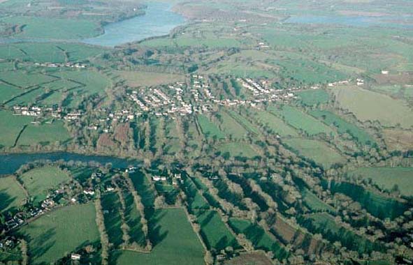
This small character area, comprising the settlement and enclosed strip-field
system of Cosheston, lies at the head of Cosheston Pill. It is within
the parish, and medieval manor, of Cosheston. Cosheston manor, recorded
in the 13th century, was a castle-guard fee of the Lordship of Pembroke,
the ward-rent being assessed at 8s in 1307. It comprised 2 knight’s
fees, held by Walter Benegar and others, in 1247, and by the Wogans of
Picton and Boulston in 1324. A ‘tenement called the Hall of Cosheston’
was acquired by the Rossant family in 1556 and was assessed for two hearths
in 1670. The hall was not on the present Cosheston Hall, which was established
in a neighbouring character area in the 19th century under the Allens
of Cresselly. The enclosed strips of the former open field system associated
with the medieval vill surround the settlement of Cosheston, which now
stretches east of the parish church. When the tithe map for Cosheston
parish was surveyed in 1841 all the main elements of the present historic
landscape were in place. The village is shown as a linear nucleation surrounded
by an extensive, enclosed strip field system. Over the past 160 years
the strip fields outside this character area have been converted to large,
regular fields. This process is still continuing.
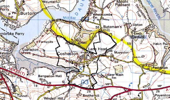
Base map reproduced from the OS map with the permission
of Ordnance Survey on behalf of The Controller of Her Majesty's Stationery
Office, © Crown Copyright 2001.
All rights reserved. Unauthorised reproduction infringes Crown Copyright
and may lead to prosecution or civil proceedings. Licence Number: GD272221
Description and essential historic landscape components
This is a small historic landscape character area centred on the village
of Cosheston, and situated on the upper reaches of Cosheston Pill on undulating
land that varies in height from sea level to over 60m. The village consists
of a clustering of dwellings spread along an east – west aligned
street, rather that a tight nucleation. There is a mixture of house styles
in the village. Older houses are 19th century, stone-built, generally
quite small, of two storeys and in the Georgian vernacular tradition,
but with a few larger examples in the polite Georgian style. Three of
the houses are Grade II listed. Most are detached, but short terraces
are also present. Individual late 20th century houses lie intermixed with
the older dwellings. Small modern housing developments are located in,
and on the fringes, of the village. The former agricultural function of
the village has been substituted by a residential function. This is exemplified
by 19th century stone built farm outbuildings that have been converted
to dwellings. The Grade II listed medieval church of St Michael’s
(with a Grade II listed cross), the rectory and the school are situated
at the western end of the village and probably indicate its historic core.
A dense scatter of 20th century houses, with a few older but modernised
dwellings lies to the south of the village on the opposite side of Cosheston
Pill. A landscape of narrow strip fields surrounds the village. Hedges
on banks are the main boundary type. In the southern section the hedges
are very overgrown, but elsewhere they are well maintained. Most of the
fields are under improved pasture. Archaeological sites are few and do
not form an important component of the historic landscape.
The village of Cosheston and its enclosed strip field system provides a distinctive historic landscape character area, but one that has rather vague borders. Therefore, there is a zone of change between this area and its neighbours, rather than a hard-edged boundary.
Sources: Cosheston Parish tithe map 1841; Jones 1996; Ludlow 1998; Owen
1918; NLW MAP 7529; Walker 1950