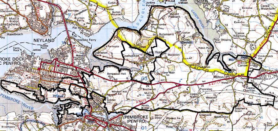
Home > Historic Landscape Characterisation > Milford Haven Area > |

CAREW, MILTON AND NASH 
GRID REFERENCE: SM 995035
AREA IN HECTARES: 1986
Historic Background
A large character area lying to the south of the Milford Haven Waterway.
It includes the ecclesiastical parishes of Pembroke St Mary, Cosheston,
Monkton, Nash and Upton, all of which lay within the medieval Lordship
of Pembroke, and Carew parish, of the medieval Barony of Carew. Most of
the present farms and landholdings can be identified with medieval manors,
which were however subject to a complex process of division and sub-infeudation
following the break-up of the Earldom of Pembroke in 1247. The part of
Pembroke St Mary parish that is situated in this character area once lay
within the Manor of Kingswood with Golden, which was a demesne manor of
the Pembroke lordship. Here arable land-use is recorded, in detailed accounts
from the 14th century and 15th century, with issues from wheat, beans,
peas, barley and oats. However, meadowland, sheep and wool are also recorded,
as well as profits from cloth processing – two fulling-mills were
established here during the 15th century. Later in the post-medieval period,
the manor became part of the Bush estate. Bangeston, also in St Mary parish,
is probably the ‘Benegareston’ that comprised 1/10th knight’s
fee held of the lordship, by John Beneger in 1324. A chapel at Upton was
recorded by Giraldus Cambrensis in c.1200, and was normally subordinate
to Nash parish. The Manor of Upton was a castle-guard fee of the Lordship
of Pembroke, and had merged with the Manor of Nash by the 14th century
under its tenant lords, the Malefants, who built a small stone castle
at Upton. The ‘Manor of Upton and Nash’ had descended to the
influential Bowens by the 16th century. Cosheston manor, recorded in the
13th century, was another castle-guard fee, comprising 2 knight’s
fees held by the Wogans of Picton and Boulston in 1324. The area includes
a small part of Monkton parish, held by the Benedictines of Monkton Priory,
Pembroke. Vills were also recorded at Brotherhill, Mayeston and Paskeston
between the 13th century and the16th century. The various ownerships appear
not to be reflected in differing tenurial arrangements, and a homogenous
pattern of large, enclosed, irregular fields exists, with little evidence
of former open field systems. Some of the enclosure appears to have been
established over former woodland – Upton and Nash are included in
George Owen’s list of the greater woods of Pembrokeshire in c.1601.
However, the eastern part of the area, within the parish and medieval
Barony of Carew, exhibits a slightly different pattern. This area, formerly
part of Carew demesne, is laid out in a system of large regular fields.
The creation of some of these enclosures can be attributed to the 16th
century lord Sir John Perrot, as they are recorded in a survey of 1592
following his attainder to the barony. Some subdivision had occurred by
the time of the tithe survey of 1839. The caput of the barony, at Carew
Castle, lies within this area. Extensively rebuilt under Perrot in the
late 16th century, it was abandoned during the 17th century. The settlement
at Carew has medieval origins, as has Carew Cheriton, the ‘church
town’ - a separate settlement around the parish church of St Mary
- which lies some distance from the castle. Milton, with its medieval
mill site(s), represented 1 knight’s fee held of the Barony, in
1362, by the Malefants. The village is probably medieval in origin; the
mansion house, however, is de novo from the 18th century. Welston Court
represents a former holding of the bishops of St Davids. Although the
area has remained overwhelmingly agricultural it does include part of
the Milford Haven waterway foreshore, which has always been important
in defining the area’s character. Jenkins Point, in particular,
was an important shipping place, with early landing stages for the Benton
and Lawrenny Quay ferries. The surrounding 18th century and 19th century
settlement has created a distinctive pattern of small fields and numerous
dispersed dwellings. Estate maps of the late 18th century and early 19th
century and tithe maps of c. 1840 show that the landscape of today had
already been established right across this area. Only minor changes have
taken place since then, such as a slight increase in the number of dwellings
along the waterway and the establishment of Cosheston Hall and Park over
what once had been fields.
Base map reproduced from the OS map with the permission
of Ordnance Survey on behalf of The Controller of Her Majesty's Stationery
Office, © Crown Copyright 2001.
All rights reserved. Unauthorised reproduction infringes Crown Copyright
and may lead to prosecution or civil proceedings. Licence Number: GD272221
Description and essential historic landscape components
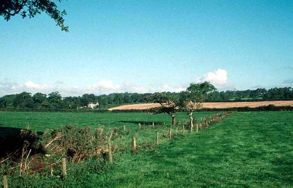
This is a relatively large historic landscape character area lying to
the south of the Milford Haven waterway and the Carew River, to the east
and south of Pembroke Dock on undulating ground lying mainly between 20m
and 50m above sea level. Mud flats, marsh and the rocky foreshore along
the Milford Haven waterway are included in this area. It is an agricultural
landscape of large, dispersed farms and large fairly regular fields. There
are a large number of listed buildings within this area. Several of them
are major houses including the ruinous medieval castle of Carew with its
massive Elizabethan wing, Upton Castle with a disused chapel set in parkland
and gardens, Cosheston Hall with its parkland, Bangeston Hall, Welston
Court, Milton House, Holyland Hotel and the Fortified Rectory at Carew
Cheriton. Clearly a vast date range and many building types are included
within these structures, from medieval defensive sites through to Victorian
mansions. They are united in providing an estate quality to large tracts
of the landscape, with parkland, stands of deciduous woodland, lodges
and home farms. Farmhouses on the home- and other substantial-farms are
generally in the Georgian tradition, stone-built and cement rendered with
slate roofs, associated with which are ranges of stone-built outbuildings,
sometimes arranged semi-formally around a yard, with large modern agricultural
structures nearby. Smaller farmhouses are also mainly 19th century and
within the Georgian tradition. There is a dispersal of 19th century and
20th century houses close to the shore of the waterway, but Milton and
Carew are the only significant nucleations. Milton comprises stone-built
vernacular houses, cottages, a public house and farm buildings, on the
outskirts of which is a late 20th century housing estate. Carew is essentially
a linear village with a terrace of 19th century houses, a ‘Flemish’
chimney – the remains of a sub-medieval house –, a 19th century
chapel and 20th century houses. Carew bridge, and the French Mill (an
imposing Georgian building, but described as a ‘French Mill’
in 1541) and its dam, an early medieval high cross, together with the
castle and the village represent an important assemblage of structures
within Carew. Carew Cheriton is a loose cluster of buildings, including
the Fortified Rectory and an Old Mortuary Chapel, which is dominated by
the St Mary’s medieval church. The small church at Nash is also
in this area, and a dovecote north of Monkton Priory. Agricultural land-use
is improved pasture with a little arable. Fields are relatively large
with boundary banks of earth topped with hedges. Hedges are generally
well maintained, but some are overgrown and others support mature trees.
These trees, together with woodland close to some of the large houses,
in the parkland, on steep valley sides and along the banks of the waterway
add to the estate character of the area. The main transport routes are
narrow winding lanes, but both the A 477(T), to Pembroke Dock and the
A 4075 cut across the area. There has been very little degradation of
the historic landscape components where this area borders Pembroke and
Pembroke Dock urban character areas. Archaeological sites are varied.
The most numerous are World War 2 defensive structures – gun emplacements,
searchlight batteries etc – followed by industrial sites, which
are mostly quarries, and limekilns. Both coastal and inland kilns are
present. Other sites include caves and find spots of prehistoric artefacts,
bronze age standing stones and bronze age burnt mounds, a holy well site
and several sites of mills.
Although well defined against the Milford Haven waterway, Carew Airfield and the two urban areas of Pembroke and Pembroke Dock, this historic landscape character area has poor definition to the south against an area that has yet to be characterised. Here there is a wide zone of change, rather than a hard-edged boundary.
Sources: Austin 1992; Austin 1993; Carew Parish tithe map 1839; Charles
1992; Cosheston Parish tithe map 1841; Jones 1986; Ludlow 1998; Ludlow
and Murphy 1995; Monkton Parish tithe map 1841; Murphy 1987; Nash Parish
tithe map 1839; NLW MAP 7557 & 7529; Owen 1897; Owen 1918; PRO D/LLC/674;
PRO D/BUSH/6/26 & 27; PRO D/ANGLE/115; PRO HDX/198/2; NLW 142296;
St Mary’s Pembroke Parish tithe map 1841; St Michael’s Pembroke
Parish tithe map 1841; Walker 1950; Willis-Bund 1902