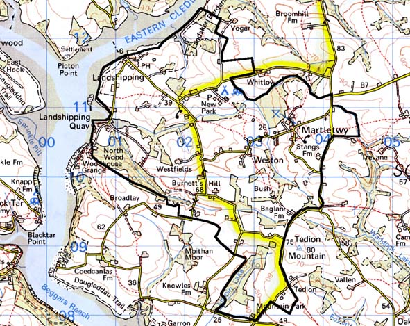
Home > Historic Landscape Characterisation > Milford Haven Area > |

MARTLETWY 
GRID REFERENCE: SN 025101
AREA IN HECTARES: 825
Historic Background
This character area situated on the upper reaches of the Eastern Cleddau
lies within the parishes of Martletwy and Lawrenny, and the medieval Barony
of Carew. The parish church of Martletwy may be a pre-conquest ecclesiastical
foundation. It was granted, with a significant tract of land in the north
of the parish, to the Knights Hospitaller at Slebech by the Lord of the
Manor John FitzRaymond de Martletwy, during the 12th century. The remainder
of the manor comprised one knight’s fee in 1362 when it was held
of the barony. Place-name evidence may indicate the presence of a motte
castle. However, by the late 16th century Landshipping appears to have
succeeded Martletwy as the caput, at which time it was occupied by the
Wyriots. The Owens who established a Renaissance garden comparable in
scale to better-known English examples followed them in the 17th century.
The garden’s formal courts and terraces can still be seen in aerial
photographs. It was abandoned by 1789, and a new house was built at Landshipping
Ferry. Much of the remaining land within this area is of fairly poor quality
and probably lay under woodland or pasture during the medieval period,
as no other medieval vills or townships can be identified. The present
landscape is post-medieval in origin. The Cleddau waterway has always
been important in defining the character of this area. The creeks and
pills were used as informal shipping places throughout the historic, and
earlier periods. A ferry was established between Landshipping Quay and
Picton by 1729. The area lies in the Pembrokeshire coalfield and waterborne
activity increased with the rise of the local mining industry. Mining
began in the late medieval period, but was a low-key affair and probably
only worked on a seasonal basis by farmers and farm labourers up to the
end of the 18th century. In 1800, Sir Hugh Owen installed the first steam
engine in the Pembrokeshire coalfield at Landshipping. Many mines were
badly waterlogged, and mining at Garden Pit, Landshipping, was abandoned
when the tide flooded the pit. Quays at Landshipping Ferry and Landshipping
Quay were constructed to serve the coal industry, while the need for workers
in the coal industry undoubtedly created the distinctive pattern of small
fields and numerous dispersed dwellings that is such an important characteristic
of this area. This settlement pattern and field pattern had been established
by the tithe survey of c.1840. Since then Martletwy village has grown
considerably, blurring its medieval pattern. Mining continued in the area
until 1947 when the industry was nationalised and all the Pembrokeshire
pits were declared uneconomic and closed.
Base map reproduced from the OS map with the permission
of Ordnance Survey on behalf of The Controller of Her Majesty's Stationery
Office, © Crown Copyright 2001.
All rights reserved. Unauthorised reproduction infringes Crown Copyright
and may lead to prosecution or civil proceedings. Licence Number: GD272221
Description and essential historic landscape components
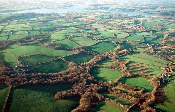
Small, irregular fields, numerous stands of deciduous woodland and a dense
scatter of cottages, houses and farms provide Martletwy with a very distinct
historic landscape character. From the mud and marsh of the Milford Haven
waterway this area rises gently in a series of rounded hills and sheltered
valleys, to over 70m above sea level. Land-use is mostly pasture, of which
most is improved, though there are pockets of rushy, rougher ground and
a little arable. Fields are small for this part of Pembrokeshire and are
divided by earth banks topped with hedges. Many of the hedges are overgrown
and support small trees. These trees together with the deciduous woodland
and small coniferous plantations lend a very wooded aspect to much of
this landscape. There are several loose clusters of houses, with Martletwy
village having the most dwellings, plus the Grade II listed medieval parish
church of St Marcellus and two 19th century chapels. But across the whole
area there is a fairly dense scatter of houses, farms and other buildings
such as the recently restored 19th century chapel at Burnett’s Hill.
Older houses of this area generally date only to the 19th century and
are stone-built, cement rendered, with slate roofs. They come in a variety
of styles, but are generally quite small. Most broadly belong in the Georgian
vernacular style, i.e. two storey, three bays, with a symmetric facade
and fairly large windows. There are, however, a significant number of
single storey cottages in the vernacular tradition. Mid and late 20th
century houses and bungalows in a variety of styles and materials lie
interspersed with the older dwellings. Farmhouses are in the same general
tradition as the other 19th century houses. Most farms have one or two
ranges of stone outbuildings together with more recent agricultural buildings
such as corrugated-iron round-headed barns, and steel and concrete structures.
The size and range of outbuildings is as so great as in other agricultural
areas of southern Pembrokeshire. Many of the older farm buildings are
no longer used, either because they are too small to be of commercial
value or because the farmland has been sold. Some have been converted
to houses, but many are derelict or becoming so. However, the remains
of Landshipping house, garden and garden walls, though largely below-ground,
are among the few unaltered Renaissance landscapes in Wales. Apart from
the settlement pattern and architecture (which is distinctive), the former
coal industry of this area has not left a major mark on the historic landscape.
The exception to this is along the shore where the remains of quays and
industrial buildings at Landshipping Ferry and Landshipping Quay testify
to the former importance of these locations for the export of coal. Other
than sites associated with the coal industry, archaeological sites in
this area are few and comprise bronze age burnt mounts, a bronze age standing
stone, and a limekiln along the foreshore.
Although this is a distinct historic landscape area, its boundaries, apart from the clearly defined border with the Milford Haven waterway are not easy to define. Therefore a zone of change rather than a hard-edged boundary exists between this area and its neighbours.
Sources: Briggs 1998; Charles 1948; Davies and Nelson 1999; Edwards 1950;
Edwards 1963; Hall et al. 2000; Lawrenny Parish tithe map 1843; Ludlow
1998; Martletwy Parish tithe map 1844; NLW VOL. 88; Owen 1897