Home > Historic Landscape Characterisation > Milford Haven Area > |

UZMASTON AND BOULSTON 
GRID REFERENCE: SM 973138
AREA IN HECTARES: 1663
Historic Background
A large character area situated on the upper reaches of the Western Cleddau.
It occupies the parishes of Haroldston St Issell’s, Uzmaston (both
in the medieval Lordship of Haverford), Boulston and Slebech (both in
the Barony of Daugleddau). Boulston and Uzmaston churches were granted
to Worcester Cathedral, and then the Knights Hospitaller at Slebech, before
1130, while Haroldston church was the property of the Augustinian Priory
at Haverfordwest. This area was subject to a complex process of division
and sub-infeudation following the break-up of the Earldom of Pembroke
in 1247 – in 1324 1/10th knight’s fee in Uzmaston was held
of the Lordship of Pembroke while one fee was held of the Lordship of
Haverford. Both Boulston, and the Manor of Picton (in the west of Slebech,
with its caput at Picton Castle) had been part of the larger Manor of
Wiston, but became separate holdings under the local Wogan family, who
were formerly tenants of the Earls of Pembroke, by the 13th century. Haroldston,
including Haylett, was recorded in 1346, represented one knight’s
fee held of the Lordship of Haverford by William Harold. It was later
acquired by the influential Perrots to form the nucleus of their vast
estates. However, the changes in ownership appear not to have resulted
in differing tenurial arrangements, and a homogenous pattern of enclosure
existed across this character area by the 18th century. This, like the
general settlement pattern, appears post-medieval in form. It comprises
large, fairly regular enclosures that appear pastoral rather than arable
and are probably contemporary with the remainder of the farms and holdings,
none of these were recorded before the mid 16th century, and could be
more recent still.It is clear from the first large scale maps that the
current pattern of field, woodland and settlement was firmly established
by the mid 18th century. There has been remarkably little change over
the following 250 years. It is surprising that historic maps show no trace
of former open field systems, a form of farming that was common in this
part of Pembrokeshire, and a method of farming that one would have expected
to have been used in this area in the medieval period.
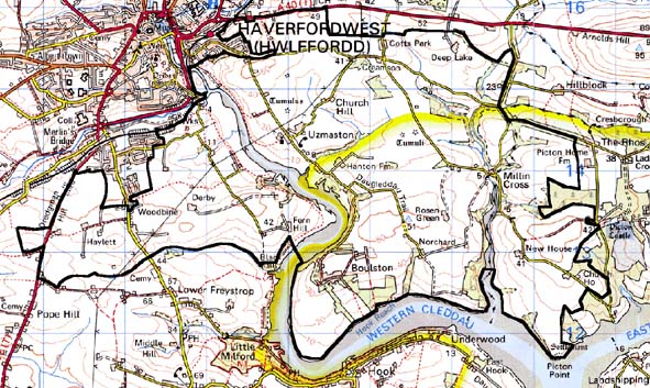
Base map reproduced from the OS map with the permission
of Ordnance Survey on behalf of The Controller of Her Majesty's Stationery
Office, © Crown Copyright 2001.
All rights reserved. Unauthorised reproduction infringes Crown Copyright
and may lead to prosecution or civil proceedings. Licence Number: GD272221
Description and essential historic landscape components
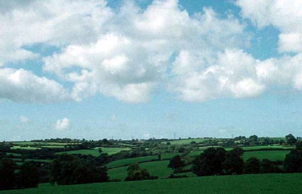
This relatively large historic landscape character area lies across the
east and west bank of the upper tidal stretches of the Western Cleddau
immediately downstream of Haverfordwest. Undulating hills, that rise to
over 50m and fall away steeply to the waterway, are covered with fields,
with deciduous woodland along the banks of the river and its tributaries
and on some of the steeper slopes. Included in this area are the upper
reaches of the waterway itself which here comprises a narrow tidal channel
flanked by marsh, mud and salt marsh. It is an agricultural landscape
characterised by dispersed farms and medium- to large-sized regularly
shaped fields. Fields are larger around Boulston and Norchard to the east
of the river. Boundary banks are topped with hedges. These are well maintained,
but with some overgrown examples and a few neglected or even derelict.
These are replaced by wire fences. Towards the eastern boundary of the
area shelter belts run alongside roads, and these, together with the overgrown
hedges and deciduous trees on the steeper slopes, lend a wooded aspect
to parts of the landscape. Agricultural land-use is almost entirely improved
pasture, with a few fields of arable and a few of rougher ground. There
is a very wide variety in farm size and farm type across the landscape,
ranging from the very large, such as Boulston Manor with its home farm,
to mid 19th century one-and-half storey, stone-built vernacular houses
with an attached small ranges of outbuildings. However, most of the farms
within this area are substantial, with late 18th century – early
19th century farmhouses in the Georgian tradition, 19th century vernacular
farmhouses and later 20th century farmhouses. Set close to the larger
farmhouses, sometimes in a formal arrangement around a courtyard, are
ranges of stone-built, slate roofed, 19th century outbuildings. Large
collections of modern steel and concrete agricultural buildings are also
a feature of many of the large farms. In some instances mid 20th century
brick and/or corrugated iron farm buildings survive. Boulston Lodge, from
1798, is Grade II listed. Other buildings include several lodges to the
larger farms, the medieval church of St Issell’s, the ruined church
at Boulston, a mid 19th century chapel and a scattering of late 20th century
houses. The latter are not common components of the landscape. Uzmaston
is the only village in this area. It is centred around the medieval parish
church and consists of a loose cluster of houses set around a green. Dwellings
are in a variety of styles and include mid 20th century council houses,
19th century vernacular stone-built houses, and late 18th century houses
in the Georgian tradition. Archaeological sites in this area are numerous
and varied. They include: several bronze age round barrows, standing stones
and burnt mounds, three iron age hillforts, a chapel site, mill sites,
a rabbit warren, the site of a manor house, deserted gardens and mansion
of Haroldston, and several limekilns along the shore of the river.
Along its northern boundary with the town of Haverfordwest this historic landscape character area is very well defined, as very few of the landscape components at this interface have been allowed to degrade. On other sides the boundary is against other agricultural areas; here there is no hard definition, rather a zone of change.
Sources: Boulston Parish tithe map 1844; Davies 1946; Jones 1996; NLW
PICTON CASTLE VOL. 1; NLW MAP 7524; NLW VOL. 88; Owen 1911; Ludlow 1998;
Slebech, Minwere and Newton Parishes tithe map 1847; Uzmaston Parish tithe
map 1841; Walker 1950