Home > Historic Landscape Characterisation > Milford Haven Area > |

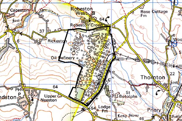
AMOCO OIL REFINERY 
GRID REFERENCE: SM 883084
AREA IN HECTARES: 163
Historic Background
Apart from a number of fields that lie within the perimeter fence, this
historic landscape character area comprises an oil refinery. It lies within
the parishes of Herbrandston and Robeston West. Most of the present farms
and landholdings can be identified with medieval manors. These manors
were subject to a complex process of division and sub-infeudation following
the break-up of the Earldom of Pembroke in 1247. The north half of the
area lay within the medieval Manor of Robeston, a member of the Lordship
of Haverford which was probably not established until the 14th century.
Extending into the west of the area, Rickeston comprised ¼ of a
knight’s fee, held directly of the Earls of Pembroke as their share
of the lordship. The southern part of the area represented the Barony
of Walwyn’s Castle’s share of Herbrandston, which comprised
2 ¾ carucates held of the barony ‘by homage’. However,
the various ownerships did not appear to be reflected in any different
tenurial arrangements, as a homogenous pattern of enclosure resulted.
Prior to the construction of the refinery the area consisted of an agricultural
landscape of regularly shaped fields. According to late estate maps these
fields changed little between the late 18th century and the construction
of the refinery. Refinery construction began in 1971 and it was opened
in 1973.
Base map reproduced from the OS map with the permission
of Ordnance Survey on behalf of The Controller of Her Majesty's Stationery
Office, © Crown Copyright 2001.
All rights reserved. Unauthorised reproduction infringes Crown Copyright
and may lead to prosecution or civil proceedings. Licence Number: GD272221
Description and essential historic landscape components
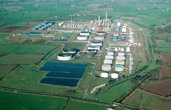
This historic landscape character area consists entirely of an oil refinery
and its infrastructure, such as access roads and railway. It is an extremely
well defined area and contrasts sharply with surrounding farmland.
Sources: McKay 1993; Herbrandston Parish Tithe Map 1839; Owen 1911; PRO
D/RKL/1191/1; PRO D/RKL/1194/2; PRO D/RKL/1194/6; PRO D/RKL/1194/9