Home > Historic Landscape Characterisation > Lower Teifi Valley > |

 TRE-RHYS
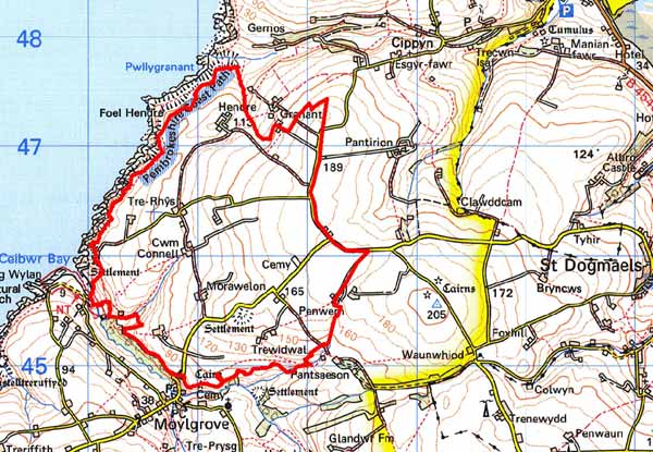
GRID REFERENCE: SN122462
AREA IN HECTARES: 447
Historic Background
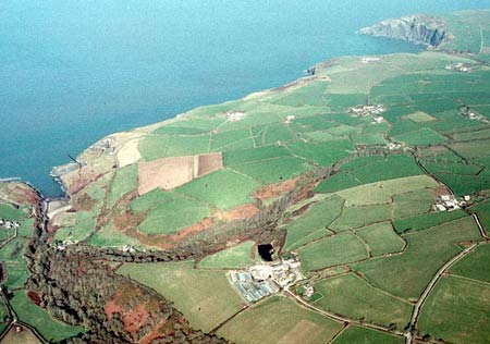
This is small area within modern Pembrokeshire comprising exposed agricultural land sloping down towards, and overlooking, the rocky Irish Sea coastline south of Cemaes Head. A hillfort lying on the cliff-top at the mouth of Cwm Trewyddel and a Bronze Age round barrow just to the southeast attest early occupation of this area. More prominent is the large, multivallate Iron Age contour hillfort of Caerau Gaer.
During the historic period, the area lay within the medieval Cantref Cemaes, in Is-Nyfer commote, in the division of Uwch Clydach. Cemaes had been brought under Anglo-Norman control by Robert FitzMartin in c.1100 and reconstituted as the Barony of Cemais. Cemais remained a marcher lordship, administered from Nevern castle, and then from Newport Castle, until 1536, when the barony was incorporated into Pembrokeshire as the Hundred of Cemaes. However, most of Is-Nyfer represented the ‘Welshry’ of the barony and remained subject to Welsh law, custom and tenurial patterns throughout the medieval period, many of which persisted into the 20th century. This northeastern part of Is-Nyfer was, moreover, held by the Welsh princes between 1191 and 1201, and again in 1215-1223. Welsh tenurial patterns, and the exposed nature of the landscape, have been largely responsible for the dispersed settlement within the region.
However, a significant early medieval presence within this landscape is indicated by the undated cist graves which have been reported from between the ramparts of Caerau Gaer. The hillfort lies in association with the field-name element eglwys, suggesting that the cemetery may have developed with the addition of a church. It has even been proposed as the initial site of St Dogmael’s monastery.
Subsequently, the character area came to lie within the parish of St Dogmaels, which was formally established after c.1100. The parish was coterminous with the manor, which comprised one knight’s fee held of the barony, as ‘St Dogmaels patria alias Cassia’, by the abbots of St Dogmaels. However, not being ‘parcel’ of the barony, the manor of St Dogmaels was not included in the detailed assessment of 1594 that survives as the ‘Extent of Cemaes’. At the dissolution, it passed to John Bradshaw of Presteigne who had purchased the abbey in 1543. The Manor of St Dogmaels survived into the 19th century. It had been acquired by the Neuadd Trefawr estate during the 17th century and was sold to David Davies of Castle Green, Cardigan, in 1862
Possible medieval vills have been suggested at Granant and at Hendre, both now represented by farmsteads. They were certainly a gentry-houses by the 16th century when referred to as the ‘caput of Granant alias Hendre’. A record of a possible vill, ‘Cilgarthen’, may be represented by the deserted settlement indicated by earthworks immediately south of Caerau Gaer.. None of the other seven dispersed farmsteads now present are recorded before the 18th century, but some are likely to have earlier origins. The present pattern of small- to medium-sized irregular fields suggests that the area was enclosed during the early post-medieval period, if not the later Middle Ages. Subdivided blocks are shown within some of these fields on the tithe map of 1838, while closer to the coast, an unenclosed block of short narrow strips is shown. These systems may be relics of arable farming under Welsh tenure, which has since ceased, and today the former strips are hardly detectable in the landscape. The Pembrokeshire Coast Path, designated in 1952, runs along the cliff-top here giving unrivalled access to the coastal scenery.
Description and essential historic landscape components
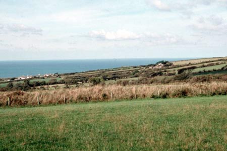
Tre-Rhys historic landscape character area lies on a very exposed west-facing coastal slope between approximately 30m and 180m above sea level. Consequently it is a treeless landscape, and hedges are reduced to low windswept straggling lines of gorse, bracken and thorn. It is an agricultural landscape characterised by small- to medium-sized irregular fields and dispersed farms. Land-use is almost entirely improved pasture. Field boundaries are high banks of earth and stone topped with low, windswept hedges and supplemented with wire fences. Cement-rendered stone is the main building material of the farmhouses. Most date to the 19th century and are relatively small, consisting of two storeys and three-bays with a central front door and five symmetrically arranged windows. Stone outbuildings are similar in date and of one or two ranges. Modern outbuildings, where present, are also small and are not a strong component of the historic landscape. Indeed there are few late 20th century buildings. Significant archaeological sites include the large Iron Age hillfort and cemetery at Caerau Gaer, a second hillfort and a Bronze Age round barrow.
Apart from where it meets the coastal slope to the west this area is not easy to define. On other sides boundaries between this area and its neighbours are broad zones of change rather than hard-edged.
Sources: Cadw – database of Building of Special
Architectural or Historic Interest; Fenton, R., 1811 A Historical Tour
through Pembrokeshire, London; Howells, B E and K A (eds.), 1977, The
Extent of Cemaes, 1594, Haverfordwest; Jones, F, 1996, Historic Houses
of Pembrokeshire and their Families, Newport; Lewis, S, 1833, A Topographical
Dictionary of Wales 1 & 2, London; Ludlow, N, 2002, ‘The Cadw
Early Medieval Ecclesiastical Sites Project, Stage 1: Pembrokeshire’,
unpublished report by Dyfed Archaeological Trust; Owen, H (ed.), 1897, The Description
of Pembrokeshire by George Owen of Henllys, Lord of Kemes 2, London; Rees,
W, 1932, ‘Map of South Wales and the Border in the XIVth century’;
Rees, W, 1951, An Historical Atlas of Wales, London; Regional Historic Environment Record housed with Dyfed Archaeological Trust; St Dogmaels parish tithe
map 1838
Base map reproduced from the OS map with the permission
of Ordnance Survey on behalf of The Controller of Her Majesty's Stationery
Office, © Crown Copyright 2001.
All rights reserved. Unauthorised reproduction infringes Crown Copyright
and may lead to prosecution or civil proceedings. Licence Number: GD272221