Home > Historic Landscape Characterisation > Lower Teifi Valley > |

 TOWYN BURROWS AND GWBERT
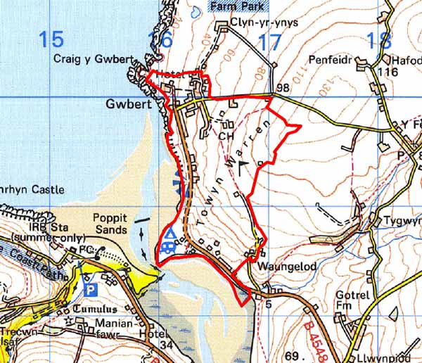
GRID REFERENCE: SN165491
AREA IN HECTARES: 143
Historic Background
This is a small area within modern Ceredigion, overlooking the scenic Teifi estuary. An Iron Age hillfort attests to early occupation of the area, but it is not a prominent feature within the landscape and no associated field systems have been recognised.
During the historic period, this character area lay within Ceredigion, in the medieval Cantref Iscoed, in the commote of Is-Hirwern. Ceredigion, including Cantref Iscoed, was briefly brought under Anglo-Norman control between 1110 and 1136, under the de Clare earls. Ceredigion remained in Welsh hands throughout the 12th and 13th centuries, until finally annexed by the English crown in 1283, when the county of Cardiganshire was created. However, Is-Hirwern commote was reliquished to the Norman King John in 1201 when it became a royal lordship, administered from Cardigan Castle. It remained - apart from a brief period of Welsh rule 1215-1223 - until the Act of Union of 1536 when it became part of the Hundred of Troedyraur. Generally the lordship remained subject to Welsh law and tenurial patterns throughout the medieval period, administered as a ‘Welshry’ This character area lies within a subdivision of the commote, Gwestfa Berwick/Ferwig, which may have pre-Norman origins. Medieval tenurial patterns - with neither vills nor knight’s fees - have been largely responsible for the dispersed settlement generally seen within the region.
Sand inundation, though probably occurring from an early date, was formerly less extensive than at present. A medieval rubbish pit was excavated in the eroding cliff-section, southwest of the present village of Gwbert, during the 1970s. A number of medieval leather shoes were recovered from the pit, as was pottery, which has given its name to ‘Gwbert Ware’. The pit appears to belong to a medieval settlement buried beneath the dunes. The place-name is thought to be a corruption of a ‘Celtic’ dedication, suggesting that a chapel may have been present. Although ‘Gwbert’ is not recorded, by name, as a settlement in medieval documentation, Towyn Farm - on the northern edge of the dunes - was recorded as a late medieval gentry house/settlement, owned by Gwilym ap Einon, constable of Cardigan Castle, in 1326. No associated landscape features can be recognised beneath the sand. Progressive besanding has meant that land use was probably always dominated by rough grazing on the burrows - the ‘Warren’ place-name clearly refers to the sand hills rather than to rabbit-farming. On the tithe map of 1839 this area is shown divided into several large enclosures in contrast with the surrounding smaller agricultural fields, but it is uncertain whether this was common land. However, a couple of isolated cottages indicates encroachment. This process does not seem to have progressed. The present village is an entirely de novo settlement of the 20th century, and it is only in the last 100 years that development - a hotel and housing at Gwbert, a caravan park and yacht club/park by the river and dispersed housing in the wind-blown sand - has had an impact on this area.
Description and essential historic landscape components
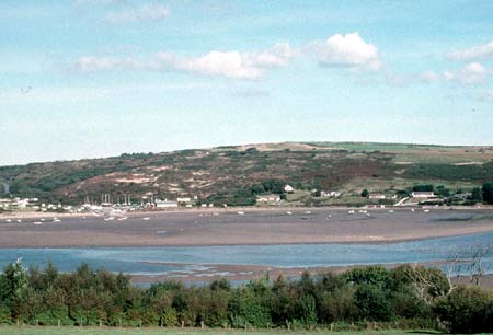
Towyn Burrows and Gwbert is a small historic landscape character area on the northern bank of the Teifi estuary, lying on exposed west-facing slopes up to 120m above sea level. Despite its size it is a complex area united by underlying wind-blown sand and/or 20th century and 21st century buildings. The wind-blown sand is most obvious on the very steep coastal slope where it is overlain by gorse scrub. A caravan park and yacht club/yard lies on the gravel and wind-blown sand spit at the mouth of the Afon Teifi, and dispersed late 20th century dwellings, mostly bungalows, lie in the wind-blown sand slopes at the southern end. At the northern end above hard-rock sea cliffs Gwbert village, which is mostly late 20th century houses but includes the large Cliff Hotel, has developed in a linear, more planned fashion. A golf course with modern clubhouse has been established on the highest point of this area. Recorded archaeology includes finds of Neolithic and medieval date as well as a possible Iron Age hillfort.
Towyn Burrows and Gwbert historic landscape character area has many different
historic landscape components from its agricultural neighbouring area.
It is, however, difficult to define its boundaries with precision.
Sources: Cadw – database of Building of Special
Architectural or Historic Interest; Dyfed Archaeological Trust, 1986,
Archaeology in Dyfed, Carmarthen; Jones, F, 2000, Historic Cardiganshire
Homes and their Families, Newport; Lewis, S, 1833, A Topographical Dictionary
of Wales 1 & 2, London; Ludlow, N, 2002, ‘The Cadw Early Medieval
Ecclesiastical Sites Project, Stage 1: Ceredigion’, unpublished
report by Dyfed Archaeological Trust; Meyrick, S R, 1810, The History and Antiquities
of Cardiganshire, London; Rees, W, 1932, ‘Map of South Wales and
the Border in the XIVth century’; Rees, W, 1951, An Historical Atlas
of Wales, London; Ferwig parish tithe map 1839; Regional Historic Environment Record housed with Dyfed Archaeological Trust
Base map reproduced from the OS map with the permission
of Ordnance Survey on behalf of The Controller of Her Majesty's Stationery
Office, © Crown Copyright 2001.
All rights reserved. Unauthorised reproduction infringes Crown Copyright
and may lead to prosecution or civil proceedings. Licence Number: GD272221