Home > Historic Landscape Characterisation > Lower Teifi Valley > |

 ST DOGMAELS
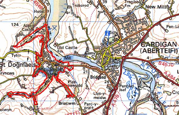
GRID REFERENCE: SN163462
AREA IN HECTARES: 71.6
Historic Background
This is a small historic landscape character area represented by the built-up area of the large village of St Dogmaels. During the historic period, the area lay within the medieval Cantref Cemaes, in Is-Nyfer commote. Cemaes had been brought under Anglo-Norman control in c.1100, under Robert FitzMartin, and reconstituted as the Barony of Cemais. Cemais remained a marcher lordship, administered from Nevern castle, and then from Newport Castle, until 1536, when the barony was incorporated into Pembrokeshire as the Hundred of Cemaes. However, most of Is-Nyfer commote represented the ‘Welshry’ of the barony and remained subject to Welsh law, custom and tenurial patterns throughout the medieval period, many of which persisted into the 20th century. The Welsh princes between 1191 and 1201, and again in 1215-1223, held this northeastern part of the Is-Nyfer.
St Dogmaels is dominated by an ecclesiastical presence, in the form of the Tironian (Benedictine) abbey of St Dogmaels. This was established by Robert FitzMartin as a priory in 1113; it was raised to abbey status in 1120. It occupies a much earlier monastic site. FitzMartin’s foundation charter described the house as the ‘old church’ of Llandudoch. The six Early Christian Monuments from the site suggest a continuous ecclesiastical presence from the 6th century onwards, which was wealthy enough to be attacked by Vikings in 988. A possible earlier monastic enclosure observed as a line of continuous property boundaries at St Dogmaels may or may not continue a curving bank recently recorded through geophysics south of the later abbey buildings. The abbey church was begun during the early 12th century. Although never completed to its original extensive plan, it had developed into a large church by the mid 13th century, central to an extensive range of masonry conventual buildings occupying a precinct that was at least 4ha in extent. The complex still forms the defining element of today’s landscape.
A settlement had developed outside the abbey by the later medieval period, directly held by the barony which may have been keen to exploit the economic potential provided by the abbey’s presence. The lords of Cemais are also recorded as having established a market here. The settlement was a manor, described as one of the ‘three corporate towns’ of Cemais in 1603 (along with Newport and Nevern), but it never appears to have been a borough. It may have remained fairly small through the medieval period. However, it was large enough to be served by a parish church dedicated to St Thomas (the abbey church being non-parochial), which stood opposite the abbey, but which has now gone. The abbey, and perhaps the settlement, were served by a mill immediately east of the abbey, and the monks had rights to an extensive fishery on the Teifi estuary. A devotional, or pilgimage chapel was established in the steep valley of Cwm Degwell to the south.
The abbey was dissolved in 1536 when the buildings were leased to John Bradshaw of Presteigne. He built a mansion for himself within the precinct, from stone robbed from the conventual buildings, but this was short-lived and the site was described as a ruin in 1603. It was bought by David Parry of Neuadd Trefawr in 1646, but does not appear to have been inhabited, and the ruins passed into the ownership of the Anglican Church, who may briefly have relocated the parish church into the abbey. However, a new parish church was established, on its present site, in the early 18th century (which was rebuilt in 1847) followed by the construction of the vicarage (and the coach-house) in 1866.
There are some early references to Seine net fishing at St Dogmaels. A medieval source mentions a salmon fishery in association with the abbey, and there is also a later record of a complaint in the reign of Elizabeth I for fishing with nets called “sayney.” Whereas seine net fishing was practiced along the shores of the estuary, the 18th century saw St Dogmaels develop into an important herring fishery. During the second half of the 19th century, St Dogmaels grew rapidly. This undoubtedly owed much to the busy trade along the Teifi, with the Port of Cardigan burgeoning and associated activity spreading to St Dogmaels. The most obvious physical symbols of this upturn in economic activity within the parish of St Dogmaels are the fine 19th century warehouses seen along the river at both Bridgend and near the Pinog. There are also a number of 19th century lime kilns along the river. Otherwise there are few structural remains to indicate the former importance of the sea trade to the community.
The settlement had become fairly sizeable by 1838, when the tithe map shows a loose nucleation of about 100 buildings centred on the abbey, though there are many gaps between them. Much rebuilding and development occurred during the late 19th and early 20th centuries, with good-quality buildings, both terraced and detached. Analysis of 19th century maps graphically shows how the village grew. By the time of the 1891 Ordnance Survey map, gaps have been infilled. In addition, a coastal gun battery was built on the southern bank of the Teifi in the 1880s. This ruined fort is now almost unrecognisable on the shore below the Webley Hotel. A workhouse was established at Albro Castle, north of the village, later in the 19th century. Another interesting development during this period was the settlement of common land along Cwm Degwel and on high ground to the south of the village. This land was virtually unsettled in the 1840s, but by 1891 formed a significant part of the village. A few of these cottages were probably tai unnos, characterised by the single dwelling standing in an enclosed garden plot.
St Dogmaels is now a popular holiday destination. The abbey has been in the care of the state since 1934 and is now one of the visitor attractions of the region. The early 19th century mill is also preserved and open to the public. However, there has been little modern commercial development.
Description and essential historic landscape components
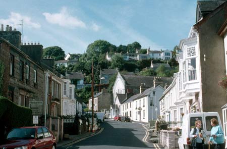
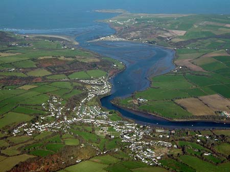
St Dogmaels is a small, built-up historic landscape character area located on the southern bank of the tidal Afon Teifi. Most of the settlement lies on relatively level ground between sea level and 30m, but on the southwestern periphery streets and houses are located on very steep slopes up to 80m above sea level. Also included are two wooded minor valleys, the larger of which, Cwm Degwell, has a minor road with dwellings along its floor. An open area containing the imposing ruins of a medieval abbey with the adjacent mid 19th century parish church lies at the centre of village. An early 19th century stone-built corn mill in working condition lies immediately to the east of the abbey ruins, on a medieval site. Streets meander from this centre in an organic fashion. There is no indication of planned settlement. Tightly-packed buildings, usually two-storey terraces, curving and straight, with some semi-detached and detached houses line these streets. Almost the whole pre 20th century housing stock dates to the 19th century, and most to the mid 19th century, with very little evidence of anything earlier. Terraces are generally multi-build, that is buildings have been fitted between existing buildings. However, there are a few examples of short single-build terraces. This pattern suggests buildings had to be fitted into existing building plots, plots that may have been established several centuries prior to the rebuilding during the 19th century. Teifi valley slate is the principal building material and north Wales slate the roofing material of these 19th century houses. Many houses are cement rendered (stucco). Occasional use is made of red brick – sometimes cement rendered. A very distinctive characteristic of some of the St Dogmaels houses is the use of pale blue/silver Teifi valley slate laid in strongly coursed bands which is separated by courses of rich brown squared stone (possibly Preseli dolerite). In some instances the slate banding has been emphasised by paint. This banding technique has been noted elsewhere, such as at Newport and Dinas in Pembrokeshire and at Cardigan, but no other location has the strong polychrome effect seen on the St Dogmaels houses, several of which are listed. Many of the 19th century houses have good period detail, such as door cases, bay windows, bargeboards and low street frontage walls with railings. Few of the terraces are single build. This mixture of narrow crowded streets rising up the steep valley side and small houses of great individual variety, but with an overall coherence of date and design, provides St Dogmaels with its strong historic landscape character.
Modern housing, individual dwellings and small estates lie at the periphery of the village and infill gaps in the historic core. Albro Castle, one of the best examples of a 19th century workhouse in Wales is located on the periphery of this area. There is a school, but few shops in the village and little in the way of modern commercial development. Concrete slipways and other facilities are provided for the launching of small boats along the river frontage, but apart from limekilns and 19th century warehouses in banded stone (now converted to other uses), there are few structural remains to indicate the former importance of the sea trade to the community. Recorded archaeology mainly consists of standing structures and buildings as described above, but also included are the early medieval inscribed stones in the abbey, church and chapel sites, burnt mounds and a Roman coin hoard.
St Dogmaels is a very distinctive historic landscape character area and contrasts strongly with the neighbouring areas of fields and farms.
Sources: Cadw – database of Building of Special
Architectural or Historic Interest; Hilling, J B, 1992, Cilgerran Castle/St
Dogmaels Abbey, Cardiff; Fenton, R., 1811 A Historical Tour through Pembrokeshire,
London; Howells, B E and K A (eds.), 1977, The Extent of Cemaes, 1594,
Haverfordwest; James, T, 1992, ‘Air photography of ecclesiastical
sites in south Wales’, in N Edwards and A Lane, The Early Church
in Wales & West, Oxford, 62-76; Jones, T, 1952, Brut y Tywysogyon,
Peniarth MS 20, Cardiff; Lewis, S, 1833, A Topographical Dictionary of
Wales 1 & 2, London; Ludlow, N, 2002, ‘The Cadw Early Medieval
Ecclesiastical Sites Project, Stage 1: Pembrokeshire’, unpublished
report by Dyfed Archaeological Trust; Maynard, D, 1993, ‘Burnt Mounds in
the St Dogmaels area of north Pembrokeshire’, Archaeology in Wales
33, 41-43; Owen, H (ed.), 1897, The Description of Pembrokeshire by George
Owen of Henllys, Lord of Kemes 2, London; Pritchard, E M, 1907, The History
of St Dogmael’s Abbey, London; Rees, W, 1932, ‘Map of South
Wales and the Border in the XIVth century’; Rees, W, 1951, An Historical
Atlas of Wales, London; Regional Historic Environment Record housed with
Dyfed Archaeological Trust; Sambrook, P, 2000, ‘St Dogmaels Historic Audit’,
unpublished report by Dyfed Archaeological Trust; St Dogmaels parish tithe map
1838; Weeks, R, 2002, The ‘Lost Market’ settlements of Pembrokeshire,
Medieval Settlement Research Group, Annual Report 17, 21-30
Base map reproduced from the OS map with the permission
of Ordnance Survey on behalf of The Controller of Her Majesty's Stationery
Office, © Crown Copyright 2001.
All rights reserved. Unauthorised reproduction infringes Crown Copyright
and may lead to prosecution or civil proceedings. Licence Number: GD272221