Home > Historic Landscape Characterisation > Lower Teifi Valley > |

 PLAS-Y-BERLLAN
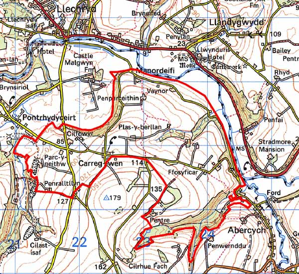
GRID REFERENCE: SN217416
AREA IN HECTARES: 473
Historic Background
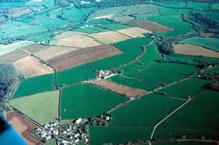
This is a medium-sized historic landscape character area within modern Pembrokeshire, represented by agricultural land comprising medium-sized, fairly regular pasture fields, with some arable and scattered woodland, on the scenic southern slopes of the Teifi valley.
This area lies within the medieval Cantref Emlyn, in Emlyn Is-Cych commote. Cantref Emlyn had been partly brought under Anglo-Norman control in c.1100 when Emlyn Is-Cych commote was reconstituted as the Lordship of Cilgerran. Cilgerran remained a marcher lordship, administered from Cilgerran Castle, which was established in c.1100. The lordship was regained by the Welsh in 1164 and remained under their rule until 1223. From 1339 it was held of the Earldom of Pembroke, which passed to the crown in the late 15th century. It was eventually abolished in 1536, when the lordship was incorporated into Pembrokeshire as the Hundred of Cilgerran. The medieval lordship, administered as a ‘Welshry’, remained subject to Welsh laws, customs and tenurial systems throughout the period. This - - with neither vills nor knight’s fees - has been largely responsible for the dispersed settlement within the region.
This character area lies within a division of the Cilgerran Lordship, Maenor Deifi, which may have pre-Norman origins. A vill was established under Welsh tenure at Cilfowyr, in the southwest part of the area, by the 14th century. Maenor Deifi was broadly coterminous with the parish of Manordeifi, which, along with its church, was established by 1291. The church, which lies close to the Teifi floodplain was, from 1339, in the gift of the Earls of Pembroke as Lords of Cilgerran. Its original dedication may have been to St Llawddog, the dominant cult in Cantref Emlyn, but it was later dedicated to St David. It ceased to be a parish church in 1899, when a new church was constructed at Carreg-wen. A chapel-of-ease to the parish had been established at Cilfowyr by the mid 16th century. It was ruinous by the early 19th century and is now defined by an earthwork.
Settlement is still dominated by Cilfowyr, which had become a gentry house by 1543. Little further settlement appears to have occurred within this character area until relatively late in the post-medieval period, although the system of medium-sized, fairly regular fields may have been established before the 18th century. In addition, the farmhouse and small estate at Pentre was first recorded in 1610. The Saunders family owned it from the earlier 18th century, passing by marriage to David Davies in the early 19th century, the family assuming the name Saunders-Davies. The mansion was rebuilt in 1820s - and marked on the 1843 tithe map - and enlarged in 1867 but the main range was demolished in the 1980s. An 1803 map of the Pentre Demesne shows enclosures, including gardens, around the house, but otherwise the landscape is very similar to that of today. Its overwhelmingly agricultural character is relieved along its western edge by the Whitland - Cardigan railway line, which was constructed in 1869. The line - which gained a place in local affections and was nicknamed the ‘Cardi Bach’ - was operational until the 1960s, mainly conveying milk and holiday traffic to Cardigan and St Dogmaels.
Description and essential historic landscape components
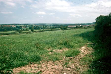
Plas-y-Berllan is an agricultural historic landscape character area lying on north- and northeast-facing valley sides of the Afon Teifi. In some sections the land rises steeply from the floodplain at 10m above sea level, but most slopes are fairly gentle. The maximum height achieved is over 170m above sea level. Land-use is improved pasture with a little arable and deciduous woodland, intermixed with a little coniferous plantation on the steeper slopes. Hedges on earth banks separate the medium-sized irregular fields. Whilst most hedges are well maintained, some are becoming overgrown and supporting large bushes and trees. These, in conjunction with the woodland on steep slopes, lend a wooded appearance to parts of the landscape. The settlement pattern is one of dispersed farms and houses. Teifi valley slate is the principal building material (cut and coursed or rubble, sometimes cement rendered) on the older buildings, nearly all of which date to the second half of the 19th century, with north Wales slate used on roofs. The majority of the farmhouses and houses are two-storeyed and three-bayed with a central front door and five symmetrically arranged windows –a style that owes more to the ‘polite’ Georgian tradition than the vernacular, and common in southwest Wales. Other houses in this area comprise a one-and-a-half storey farmhouse with strong vernacular traits, the formal early 19th century two-storey six-bay Pentre farmhouse and attached cottage, representing the home farm of the mansion demolished in the 1980s, a small mid 19th century estate cottage, and the Regency style mid 19th century Old Rectory, next to the medieval parish church. Older farm buildings are relatively small, clearly related to the size of the farm holding, and generally consist of one or two ranges with barns, cow houses, stables etc. contained within them. Some are in poor condition and others have been converted to non-agricultural uses. Larger farms have large ranges of modern concrete, steel and asbestos agricultural buildings. There is a loose cluster of mainly modern houses at Carreg-wen centred on the listed, 19th century parish church and rectory, and there are a few other modern houses scattered across the area. The other important building is the medieval parish church of Manordeifi, with a full suite of unaltered, late 17th - early 19th century fittings. The only roads in this area are narrow lanes and tracks for local traffic. Apart from standing buildings, the site of Cilfowyr Chapel and the course of the Whitland - Cardigan railway line, there is very little recorded archaeology in this area.
This area is well-defined to the west where it borders the parkland of Castell Malgwyn and to the north against the Teifi floodplain. Elsewhere there is no hard edged boundary, rather a broad zone of change exists between this area and its neighbours.
Sources: Cadw – database of Building of Special
Architectural or Historic Interest; Craster, O E, 1957, Cilgerran Castle,
London; Fenton, R., 1811 A Historical Tour through Pembrokeshire, London;
Jones, F, 1996, Historic Houses of Pembrokeshire and their Families, Newport;
Lewis, S, 1833, A Topographical Dictionary of Wales 1 & 2, London;
Ludlow, N, 2000, ‘The Cadw Welsh Historic Churches Project: Pembrokeshire
churches’, unpublished report by Dyfed Archaeological Trust; Ludlow, N,
2002, ‘The Cadw Early Medieval Ecclesiastical Sites Project, Stage
1: Pembrokeshire’, unpublished report by Dyfed Archaeological Trust; Manordeifi
parish tithe map 1842; National Library of Wales Rev J C Davies Deposit
Map Book 1803, p1; Owen, H (ed.), 1914, Calendar of Pembrokeshire Records,
2, London; Price, M R C, 1984, The Whitland and Cardigan Railway, Oxford;
Rees, W, 1932, ‘Map of South Wales and the Border in the XIVth century’;
Rees, W, 1951, An Historical Atlas of Wales, London; Regional Historic Environment Record housed with Dyfed Archaeological Trust
Base map reproduced from the OS map with the permission
of Ordnance Survey on behalf of The Controller of Her Majesty's Stationery
Office, © Crown Copyright 2001.
All rights reserved. Unauthorised reproduction infringes Crown Copyright
and may lead to prosecution or civil proceedings. Licence Number: GD272221