Home > Historic Landscape Characterisation > Lower Teifi Valley > |

 LLECHRYD
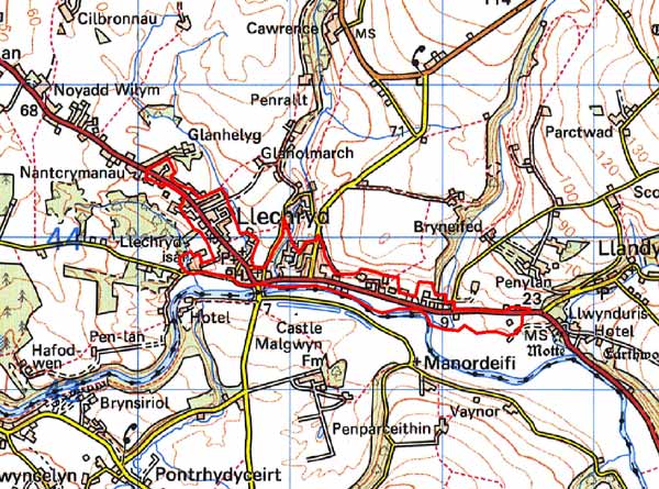
GRID REFERENCE: SN221439
AREA IN HECTARES: 56
Historic Background
A small area within modern Ceredigion, comprising the built-up area of Llechryd village and its environs, on the north bank of the Afon Teifi During the historic period, this character area lay within Ceredigion, in Cantref Iscoed, in the commote of Is-Hirwern. Ceredigion, including Cantref Iscoed, was briefly brought under Anglo-Norman control between 1110 and 1136, under the de Clare earls. It is probably during this period that most of the numerous castles within this this part of Ceredigion were established, some of them possibly having been built during the Welsh reconquest of 1135-6. Ceredigion remained in Welsh hands throughout the 12th and 13th centuries, until finally annexed by the English crown in 1283, when the county of Cardiganshire was created. However, Is-Hirwern commote was reliquished to the Norman King John in 1201 when it became a royal lordship, administered from Cardigan Castle. It remained - apart from a brief period of Welsh rule 1215-1223 - until the Act of Union of 1536 when it became part of the Hundred of Troedyraur. Generally the lordship remained subject to Welsh law and tenurial patterns throughout the medieval period, administered as a ‘Welshry’
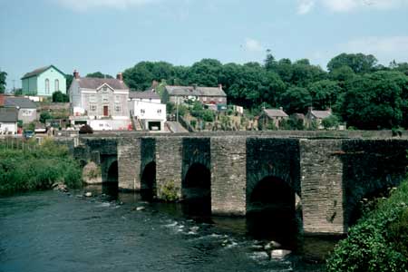
As a toponome if not a settlement, Llechryd may have earlier origins - it has been tentatively identified with the ‘Llech-y-crau’, recorded in 1088 as a battle-site and which was clearly a recognised location, and this area lies within a division of Is-Hirwern commote, Gwestfa Camros, which may have pre-Norman origins. Nevertheless Llechryd, and its history, are dominated by the bridge over the Teifi. The present structure is 17th century, but the crossing point has documented medieval origins, probably as a ford. The crossing was clearly the impetus for the development of a medieval settlement in the form of a vill which, unusually for the region, appears to have developed into a nucleation at an early date. This development may have been encouraged by the crown, or by the Bishops of St Davids to whom the parish of Llangoedmor, within which Llechryd lay, was appropriated from the late 13th century onwards. A chapelry to Llangoedmor, dedicated to the Holy Cross, was built to serve this emerging community, probably during the 14th century after the establishment of the parish. Its remains lie on the bank of the Afon Teifi, at the centre of the village.
The (re)building of the bridge in the 17th century was a further spur to this development, which may have continued uninterrupted from the medieval period. Holy Cross became a parish church in its own right, remaining parochial throughout most of the post-medieval period. Between 1764 and 1770 an extensive iron- and tinplate works was established at Castell Malgwyn, on the banks of the Teifi, just south of this area at Penygored. The works were successful, passing through several hands until purchased by Sir Benjamin Hammet, who also bought the Castell Malgwyn estate. It ceased operating in 1806. There is no evidence of worker housing in the vicinity of the tinworks site and so it is likely that the workers settled in Llechryd. Further impetus for growth occurred when the A484 through the village was turnpiked in the late 18th century, the section leading eastwards out of the village along the north side of the Teifi having been newly built new for the purpose. The section leading northwest from the village may have medieval origins and most later development has occurred along this road. The tithe map of 1839 shows c.12 buildings in a cluster north of the bridge, all of which were rebuilt during the 19th century expansion of the village. This expansion meant that Holy Cross Church fell into disused and was superseded by a new church, alongside the A484, in the later 19th century. The village continues to expand.
Description and essential historic landscape components
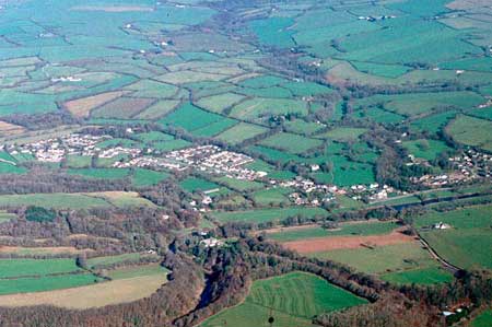
Llechryd is a small, built up historic landscape character area lying on the gently sloping north bank of the Afon Teifi between 10m and 50m above sea level. The core of the settlement consists of a cluster of 19th century buildings to the north of the 17th century Llechryd Bridge. From this core dispersed linear settlement spreads eastward along the edge of the valley floor on the north side of the A484 and northwards along the same road. Older buildings date to the 19th century and are constructed from Teifi valley slate. This is roughly squared into blocks or slabs and roughly coursed. Included in the village core are substantial mid to late 19th century middle class detached houses in the Georgian tradition (including one listed example), but most of the mid- to late-19th century domestic buildings in Llechryd are more modest worker houses, short terraces, semi-detached and detached. Having said that, there is a very strong estate character to some of the buildings in the village, with a 19th century Tudor-gothic villa, a cottage with gothic detailing, a lodge to Pencraig Farm and a gated entrance to Glanarberth alongside the main road. Listed outbuildings to the Glanarberth estate are included in this area, although the house has been demolished. Other assumed estate influence is a series of houses, usually with small agricultural outbuildings, evenly spaced along the A484 north of the village. The line of these house extends beyond the village limits into Croes-y-Llan historic landscape area, and are dealt with in more detail there, but they are included here as 20th century housing has subsumed them into Llechryd. As mentioned above there is modern housing. This has mainly developed along the main A484 northwest of the village, both linearly and in small housing estates. As well as secular buildings the village has a strong ecclesiastical element with a listed 19th century chapel and church, and the ruined medieval church of Holy Cross at the heart of the village. A modern water treatment plant lies on the outskirts.
Sources: Brooke, E H, 1932, Monograph of Tinplate
Works in Great Britain, Swansea; Cadw – database of Building of
Special Architectural or Historic Interest; Cadw 2002, Register of Landscapes,
Parks and Gardens of Special Historic Interest in Wales, Part 1 Parks
and Gardens, Carmarthenshire, Ceredigion & Pembrokeshire; Jones, T,
1952, Brut y Tywysogyon, Peniarth MS 20, Cardiff; Lewis, S, 1833, A Topographical
Dictionary of Wales 1 & 2, London; Llangoedmor parish tithe map 1839;
Llechryd parish tithe map 1842; Ludlow, N, 2002, ‘The Cadw Early
Medieval Ecclesiastical Sites Project, Stage 1: Ceredigion’, unpublished
report by Dyfed Archaeological Trust; Meyrick, S R, 1810, The History and Antiquities
of Cardiganshire, London; Rees, W, 1932, ‘Map of South Wales and
the Border in the XIVth century’; Rees, W, 1951, An Historical Atlas
of Wales, London; Regional Historic Environment Record housed with Dyfed Archaeological Trust; Willis-Bund, J W (ed.), 1902, The Black Book of St Davids,
London
Base map reproduced from the OS map with the permission
of Ordnance Survey on behalf of The Controller of Her Majesty's Stationery
Office, © Crown Copyright 2001.
All rights reserved. Unauthorised reproduction infringes Crown Copyright
and may lead to prosecution or civil proceedings. Licence Number: GD272221