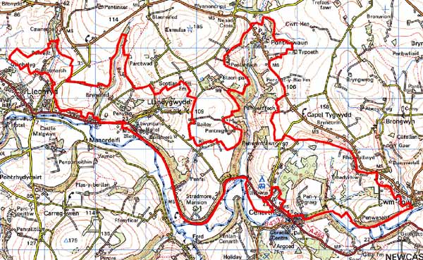
Home > Historic Landscape Characterisation > Lower Teifi Valley > |

 LLANDYGWYDD
GRID REFERENCE: SN233435
AREA IN HECTARES: 1052
Historic Background
During the historic period, this character area lay within Ceredigion, in the medieval Cantref Iscoed, divided between the commotes of Uwch-Hirwern and Is-Hirwern, which were separated by the steep, north-south valley of the Afon Hirwaun. Ceredigion, including Cantref Iscoed, was briefly brought under Anglo-Norman control between 1110 and 1136, under the de Clare earls. It is probably during this period that most of the numerous castles within this this part of Ceredigion were established, some of them possibly having been built during the Welsh reconquest of 1135-6. Ceredigion remained in Welsh hands throughout the 12th and 13th centuries, until finally annexed by the English crown in 1283, when the county of Cardiganshire was created. However, Is-Hirwern commote was reliquished to the Norman King John in 1201 when it became a royal lordship, administered from Cardigan Castle. It remained - apart from a brief period of Welsh rule 1215-1223 - until the Act of Union of 1536 when it became part of the Hundred of Troedyraur. Generally the lordship remained subject to Welsh law and tenurial patterns throughout the medieval period, administered as a ‘Welshry’. A motte-castle, established near Llwynduris, overlooking the northern edge of the Teifi floodplain, may have become the centre of a small vill. A vill had certainly been established by the late 13th century, which was formally constituted as the Manor of Llandygwydd, probably under the patronage of the Bishops of St Davids who had acquired the parish of Llandygwydd, and who established a fair in the manor.
Llandygwydd parish church (which was rebuilt in the 19th century immediately to the east of its predecessor) may have been established at the same time as the motte, but it is more likely to be contemporary with its grant to St Davids as it lies 0.5km northeast of the motte. The motte appears to have been abandoned at an early date and was replaced by the late medieval manor house (or gentry-house) probably represented by the square earthwork to the west. This is probably the Llwynduris referred to in 1507, when it was the property of the Bishops, under lease to Gtuffudd Willam Madog. Otherwise, the area in general remained subject to Welsh tenurial patterns - with neither vills nor knight’s fees - which were largely responsible for the dispersed settlement pattern within the region.
No medieval nucleation occurred, the present settlement at Llandygwydd, whilst focused on the church and, presumably, the site of the medieval vill, is entirely from the later post-medieval period, represented by a straggling row of cottages leading up a small valley from the church. The loose cluster at Ponthirwaun is also late post-medieval and, like Capel Tygwydd just beyond this character area, developed during the early 19th century along the B4570 and around an independent chapel that was established in 1840. A nearby quarry may have encouraged its growth. Settlement has continued to develop, with 20th century infilling. The area throughout is characterised by scattered farmsteads most of which are contemporary with the present landscape of large, regular fields, although some may have earlier origins This landscape appears to be late post-medieval and had assumed its present form by the late 18th century when estate maps depict it as it is today. Some of the farms developed into fairly substantial gentry-houses, exploiting the fine southerly aspect, and the area developed a ‘polite’ veneer. These include the 17th century Stradmore Mansion, recorded in 1610 but later resited, Blaenpant, recorded in 1621, and Penylan. Manor Eifed was established before 1766. The road that now flanks the southern edge of the area - the A484 - was newly constructed in the late 18th century as a turnpike.
Description and essential historic landscape components
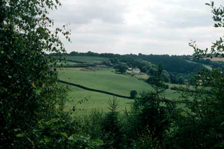
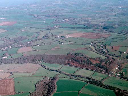
Llandygwydd is a large historic landscape character area over 9km from east to west lying on the south-facing valley side of the Afon Teifi. From the floodplain at approximately 10m above sea level the land rises very steeply to over 80m before levelling out to more undulating ground that continues to rise to over 100m. South-flowing tributary streams in steep-sided valleys dissect the area. Semi-natural deciduous woodland and coniferous plantations cloak the steep slopes, lending a wooded appearance to much of the landscape, especially that part in the Teifi valley. Agricultural land-use is predominantly improved pasture with a little arable. Hedges on earth banks bound the medium-sized irregular fields. These hedges are generally well maintained but to the west, and on some higher ground, they are more commonly overgrown, and in some instances reduced to straggling lines of bushes. The settlement pattern is one of dispersed farms and houses with clusterings at Ponthirwaun and Llandygwydd. Almost the whole pre-modern building stock in this area belongs to the 19th century, with Teifi valley slate (both bare and cement-rendered), and north Wales slate being the principal building materials. House types represent a large socio-economic range. Penylan is a large listed formal house with a walled garden, coach house and stables. This with Manor Elfed, an early 19th century listed Georgian style gentry house, and Stradmore Mansion with its home farm, it lies at the upper end of the scale. Most farmhouses are more modest and comprise a two storey and three-window façade, with symmetrical layout, a type of structure that is derived from the Georgian style, even though most date to the latter 19th century, rather than the vernacular tradition. Contemporary farm buildings are more substantial than in neighbouring areas, presumably reflecting the size of 19th century land holding, and often comprise two or three ranges of building, with barn, cow house, stables etc usually present. Occasional smaller farmhouses with more vernacular traits and smaller ranges of outbuildings are present. Some of the older outbuildings are beginning to fall into disuse. Working farms have substantial sets of modern concrete, steel and asbestos agricultural buildings. At Rhyd, a single storey clom (earth), listed farmhouse (now used as an agricultural outbuilding) with thatched roof under corrugated iron represents an older building tradition, one that was replaced by stone and slate during the 19th century. Ponthirwaun is a loose cluster of 19th century two storey workers’ houses in cut and coursed Teifi valley slate, a stone-built listed chapel and a few modern houses. An old, large quarry indicates one possible reason for the development of this hamlet. Llandygwydd hamlet is centred on a grouping of 19th century buildings including the parish church, a coach house and stables on the edge of the churchyard, a Tudor-Gothic vicarage and a gothick cottage, with a few one and two storey 19th century worker cottages. Loosely clustered modern housing, in a variety of styles and materials, has infilled gaps between older buildings and spreads up a minor road to the east of the church. There is a scatter of other modern houses across this area. Apart from the A484 which winds sinuously along the edge of the Teifi floodplain on the edge of this area, the only other roads are lanes and tracks for local traffic. Most of the 54 recorded archaeological sites consist of buildings, some of which are described above. However, there are several significant sites, and although these do not strongly characterise the area they indicate long human activity in this landscape. These include Llwynduris medieval earthwork castle, anIron Age hillfort, a medieval holy well, and other possible medieval sites known only through documentation.
This area is well defined to the south where it borders the Teifi floodplain and the built-up areas of Cenarth and Llechryd. To the north definition is less satisfactory. Here the medium-sized fields and large number of farms merge with higher land of larger fields and fewer farms.
Sources: Cadw – database of Building of Special
Architectural or Historic Interest; Jones, F, 2000, Historic Cardiganshire
Homes and their Families, Newport; King, D J C, 1988, Castellarium Anglicanum,
New York; Lewis, S, 1833, A Topographical Dictionary of Wales 1 &
2, London; Llandygwydd parish tithe map 1842; Llangoedmor parish tithe
map 1839; Ludlow, N, 2000, ‘The Cadw Welsh Historic Churches Project:
Ceredigion churches’, unpublished report by Dyfed Archaeological Trust;
Meyrick, S R, 1810, The History and Antiquities of Cardiganshire, London;
National Library of Wales 7616 134/1/19, 1758; Rawlins, B J, 1987, The
Parish Churches and Nonconformist Chapels of Wales: Their Records and
Where to Find Them, Salt Lake City; Rees, W, 1932, ‘Map of South
Wales and the Border in the XIVth century’; Rees, W, 1951, An Historical
Atlas of Wales, London; Regional Historic Environment Record housed with
Dyfed Archaeological Trust; Willis-Bund, J W (ed.), 1902, The Black Book of St
Davids, London
Base map reproduced from the OS map with the permission
of Ordnance Survey on behalf of The Controller of Her Majesty's Stationery
Office, © Crown Copyright 2001.
All rights reserved. Unauthorised reproduction infringes Crown Copyright
and may lead to prosecution or civil proceedings. Licence Number: GD272221