Home > Historic Landscape Characterisation > Lower Teifi Valley > |

 CROES Y LLAN
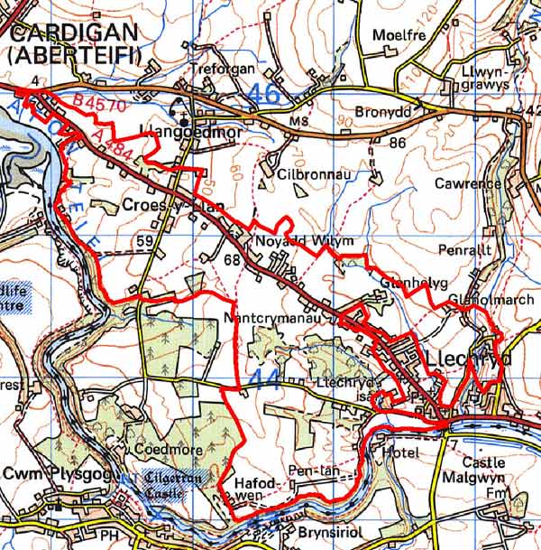
GRID REFERENCE: SN204444
AREA IN HECTARES: 345
Historic Background
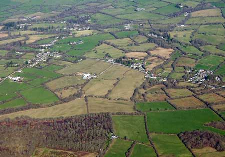
An area within modern Ceredigion, comprising a system of small irregular fields and numerous small agricultural holdings, on the undulating plateau north of the Afon Teifi.
During the historic period, this character area lay within Ceredigion, in the medieval Cantref Iscoed, divided between the commotes of Uwch-Hirwern and Is-Hirwern, which were separated by the steep, north-south valley of the Afon Hirwaun. Ceredigion, including Cantref Iscoed, was briefly brought under Anglo-Norman control between 1110 and 1136, under the de Clare earls. It is probably during this period that most of the numerous castles within this this part of Ceredigion were established, some of them possibly having been built during the Welsh reconquest of 1135-6. Ceredigion remained in Welsh hands throughout the 12th and 13th centuries, until finally annexed by the English crown in 1283, when the county of Cardiganshire was created. However, Is-Hirwern commote was reliquished to the Norman King John in 1201 when it became a royal lordship, administered from Cardigan Castle. It remained - apart from a brief period of Welsh rule 1215-1223 - until the Act of Union of 1536 when it became part of the Hundred of Troedyraur. Generally the lordship remained subject to Welsh law and tenurial patterns throughout the medieval period, administered as a ‘Welshry’ This character area lies within a subdivision of the commote, Gwestfa Camros, which may have pre-Norman origins. Medieval tenurial patterns - with neither vills nor knight’s fees - have been largely responsible for the dispersed settlement generally seen within the region.
There is little documented settlement within this character area prior to the 19th century, although Rosehill House is said to contain 17th century elements. The distinctive landscape of many small, evenly distributed farms of this character area appears to represent estate planning or the break-up of a large estate either sold, or rented, as lots, and is likely to be later post-medieval in origin rather than earlier. Whatever its origins, the process was complete by c.1840 when the tithe maps show a landscape similar to today’s. The later 19th century and 20th century have seen much infilling, particularly along the A484 into Cardigan, and either side of its junction at Croes y llan. This road was turnpiked in the late 18th century but has origins as a medieval route to the ford/bridge at Llechryd. Part of the area is now a nature reserve.
Description and essential historic landscape components
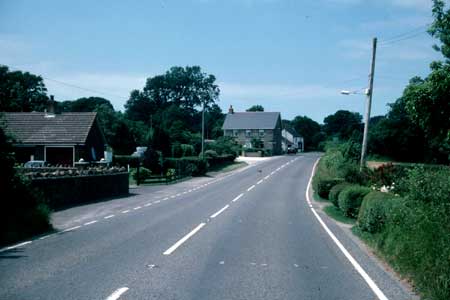
Croes y Llan is an agricultural historic landscape character area lying on the gently undulating southwest-facing valley side of the Afon Teifi between 10m and 60m above sea level. It is characterised by its system of small irregular fields and the settlement pattern of numerous small agricultural holdings. Land-use is a mixture of improved pasture and poorer quality unimproved grazing with rushes. Hedges on earth banks bound the fields. These hedges are frequently overgrown, often reduced to straggling lines of bushes sometimes with trees. These trees in combination with small stands of deciduous woodland and small coniferous plantations lend a wooded aspect to parts of the landscape. Older buildings are almost entirely 19th century in date, and built of Teifi valley slate with north Wales slate roofs. There is a fairly tight distribution of agricultural smallholdings alongside the A484. Some of these houses are early to mid 19th century, cement rendered, and have strong vernacular traits such as small windows and asymmetrical, low elevations. Most, however, are later 19th century in date, of bare stone and owe more to the polite Georgian tradition than the vernacular –the typical southwest Wales style of two storeys and three-bays with a central front door and five symmetrically arranged windows. These houses are evenly spaced along the road and unusually have their gable ends to the road, not fronting the road, as is the norm. A single stone built agricultural outbuilding, sometimes attached in line to the dwelling, is usually associated with these houses. Many of these outbuildings are not now used for agricultural purposes. Llechryd village has expanded to include some of these agricultural holdings within its boundary. Other farms are in a similar style to those on the main road, and include the listed early 19th century example of Derwenlas. An exception is the listed Rosehill which is believed to include 17th century elements, and the use of brick in a few late 19th century – early 20th century houses and outbuildings. There is a fairly dense distribution of modern houses in a variety of styles, with a noticeable cluster and linear development down side roads at Croes y Llan. Along the main road these modern dwellings have infilled some of the gaps between the smallholdings. Some have maintained the gable end to road tradition. There are no archaeological sites other than those associated with the buildings described above.
This is a distinct area with both its field system and settlement pattern contrasting with that of its neighbours.
Sources: Cadw – database of Building of Special
Architectural or Historic Interest; Jones, F, 2000, Historic Cardiganshire
Homes and their Families, Newport; Lewis, S, 1833, A Topographical Dictionary
of Wales 1 & 2, London; Llechryd parish tithe map 1842; Llangoedmor
parish tithe map 1839; Meyrick, S R, 1810, The History and Antiquities
of Cardiganshire, London; Rees, W, 1932, ‘Map of South Wales and
the Border in the XIVth century’; Rees, W, 1951, An Historical Atlas
of Wales, London; Regional Historic Environment Record housed with Dyfed Archaeological Trust
Base map reproduced from the OS map with the permission
of Ordnance Survey on behalf of The Controller of Her Majesty's Stationery
Office, © Crown Copyright 2001.
All rights reserved. Unauthorised reproduction infringes Crown Copyright
and may lead to prosecution or civil proceedings. Licence Number: GD272221