Home > Historic Landscape Characterisation > Lower Teifi Valley > |

 COASTAL STRIP - POPPIT TO NEWPORT

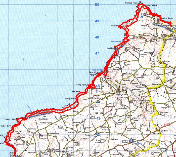
GRID REFERENCE: SN102453
AREA IN HECTARES: 212
Historic Background
This is a long, narrow area within modern Pembrokeshire,
represented by the steep coastal cliffs between Poppit Sands, at the mouth
of the Teifi estuary, and Newport to the west.
During the historic period, the area lay within the medieval Cantref Cemaes,
in Is-Nyfer commote. Cemaes had been brought under Anglo-Norman control
by Robert FitzMartin in c.1100 and reconstituted as the Barony of Cemais.
Cemais remained a marcher lordship, administered from Nevern castle, and
then from Newport Castle, until 1536, when the barony was incorporated
into Pembrokeshire as the Hundred of Cemaes. However, most of Is-Nyfer
represented the ‘Welshry’ of the barony and remained subject
to Welsh law, custom and tenurial patterns throughout the medieval period,
many of which persisted into the 20th century. The Welsh princes between
1191 and 1201, and again in 1215-1223 moreover, held this northeastern
part of Is-Nyfer. These Welsh tenurial patterns have been largely responsible
for the dispersed settlement within the region. This coastal strip, which
is very narrow, has always been marginal land and was presumably used
for rough grazing from an early period. It is shown as today on the tithe
maps from the 1840s. No settlement sites from the historic period have
been recognised within this strip, but evidence of post-medieval use of
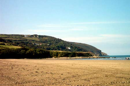
the area is provided by a number of quarries. Poppit Sands occupies a
scenic estuary setting with extensive sands, which are very popular with
visitors. A caravan park and its services - though just outside this character
area - are the dominant feature of the landscape here. Meanwhile, the
Pembrokeshire Coast Path, designated in 1952, starts at Poppit and gives
unrivalled access to coastal scenery.
Description and essential historic landscape components
This historic landscape character area consists of the narrow coastal strip from Poppit sands on the Teifi estuary to Newport sands, a distance of approximately 19km. It is very narrow, rarely achieving a width of over 150m. It consists of vertical hard-rock sea cliffs rising to over 150m in places but generally lower, and a narrow band of rough ground sandwiched between the cliff top and farmland. The Pembrokeshire Coast Path runs along the cliff top. There are no inhabited buildings. Recorded archaeology consists of two Iron Age hillforts, burnt mounds and scatters of prehistoric finds and several post medieval sites including quarries.
The coastal strip is a distinct historic character area and contrasts with the fields and farms of neighbouring character areas.
Sources: Charles, B G, 1948, ‘The Second Book
of George Owen’s Description of Penbrokeshire’, National Library
of Wales Journal 5, 265-285; Fenton, R., 1811 A Historical Tour through
Pembrokeshire, London; Howells, B E and K A (eds.), 1977, The Extent of
Cemaes, 1594, Haverfordwest; Lewis, S, 1833, A Topographical Dictionary
of Wales 1 & 2, London; Maynard, D, 1993, ‘Burnt Mounds in the
St Dogmaels area of north Pembrokeshire’, Archaeology in Wales 33,
41-43; Moylgrove parish tithe map 1847; Owen, H (ed.), 1897, The Description
of Pembrokeshire by George Owen of Henllys, Lord of Kemes 2, London; Nevern
parish tithe map 1843; Rees, W, 1932, ‘Map of South Wales and the
Border in the XIVth century’; Rees, W, 1951, An Historical Atlas
of Wales, London; Regional Historic Environment Record housed with Dyfed Archaeological Trust; Sambrook, P, 2000, ‘St Dogmaels Historic Audit’,
unpublished report by Dyfed Archaeological Trust; St Dogmaels parish tithe map
1838
Base map reproduced from the OS map with the permission
of Ordnance Survey on behalf of The Controller of Her Majesty's Stationery
Office, © Crown Copyright 2001.
All rights reserved. Unauthorised reproduction infringes Crown Copyright
and may lead to prosecution or civil proceedings. Licence Number: GD272221