Home > Historic Landscape Characterisation > Lower Teifi Valley > |

 CENARTH
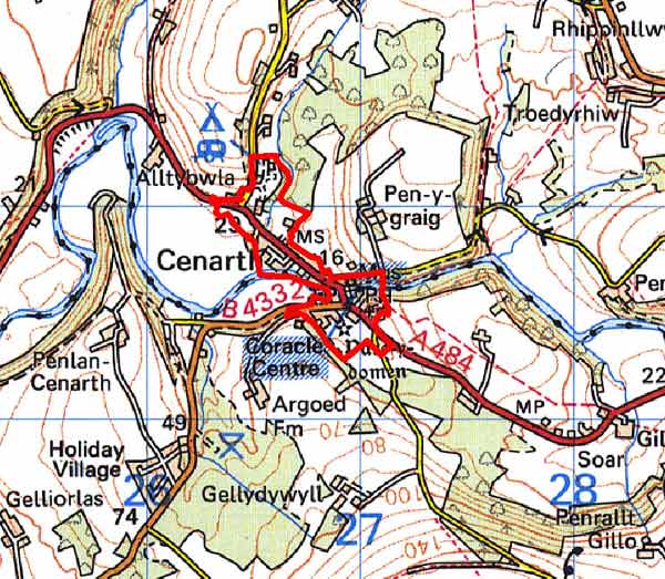
GRID REFERENCE: SN267417
AREA IN HECTARES: 25
Historic Background
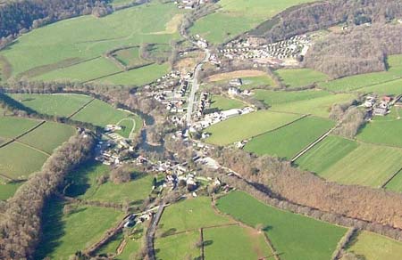
Cenarth is small area within modern Carmarthenshire and Ceredigion comprising the built-up area of the village of Cenarth. It lies either side of Afon Teifi and Cenarth Falls, a renowned beauty-spot which attracts many visitors and is one of the main raisons d’être for the development of the village. The bulk of this character area lies to the south of the Teifi, within the medieval Cantref Emlyn, in Emlyn Uwch-Cych commote. Emlyn had been partly brought under Anglo-Norman control in c.1100 when Emlyn Is-Cych commote was reconstituted as the Lordship of Cilgerran. Numerous castles were established in Uwch-Cych - none of which has any recorded history. Cenarth (or ‘Cenarth Mawr’ as it was then called) was the commotal centre of Emlyn Uwch-Cych, and a motte-castle (now ‘Parc-y-domen’) was established here. However, the commote was back under Welsh control by the 1130s, and remained such throughout the 12th -and early 13th centuries. It is possible that the pre-Norman administrative centre may have occupied the site of Parc y domen castle, which lay immediately south of Cenarth parish church.
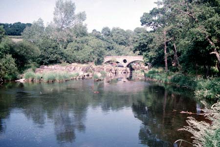
The church was an important early medieval ecclesiastical foundation, mentioned in a text of the Llandaff Charters from the 6th century. It was rebuilt in the 19th century and still dominates the village from its circular churchyard high on a prominent knoll south of the Teifi. We have an important - and unique - eye-witness description of Cenarth during the 1180s, when Gerald of Wales described it as ‘a flourishing (salmon) fishing-station. The waters of the Teifi run ceaselessly over (the falls), falling with a mighty roar into the abyss below. Now it is from these depths that the salmon ascend to the.. rock above.... The church dedicated to St Llawddog, his mill, the bridge with its fishing-station and a most attractive garden all stand together on a small plot of ground.’ It is interesting to note that a bridge and mill, presumably on the same site as the present structures, were already present, but it would seem that the castle had become disused. Neither the castle nor the church became a focus for settlement.
The commote of Uwch-Cych was appropriated by the Anglo-Norman Marshal Earls of Pembroke in 1223, but was granted to Maredudd ap Rhys, with whose family it remained until finally annexed by the English crown in 1283. It eventually formed part of the Hundred of Elvet in Carmarthenshire, in 1536. Uwch-Cych was granted to royal favourite Sir Rhys ap Thomas in the late 15th century, reverted to the crown in 1525 and was to be granted in 1546 to Sir Thomas Jones of Haroldston, Pembrokeshire. It remained in this family for several generations, eventually passing by marriage to the Vaughans’ Golden Grove Estate, which in the 19th century still owned almost all the land on the southern side of the Teifi from Pentre-cwrt in the east to Cenarth in the west. The medieval Welsh tenurial pattern - with neither vills nor knight’s fees - has been largely responsible for the dispersed settlement within the region.
Little domestic settlement appears to have occurred at Cenarth until the later 18th century. An estate map of 1768 records most of Cenarth village as part of the Gelly Dowill demesne. The village was then very small, just the church and 8 or so loosely clustered dwellings and small farms. However, the small amounts of land attached to the farms, either as small, enclosed fields or enclosed strips, appear to indicates the earlier existence of an open field system or, more likely, shared grazing strips within unenclosed land as seen elsewhere in Uwch Cych. Cenarth Mill, recorded in the 1180s, was a crown possession in 1298 when it was held by the Prince of Wales. It remained part of the royal estate until the early 17th century, and from c.1630 onwards was part of the estate of the Vaughans of Golden Grove, passing to the Earls of Cawdor who held it until 1970. It probably provided the economic mainstay of the small settlement, and its 19th entury growth, along with the salmon-fishing mentioned by Gerald of Wales, which was traditionally undertaken in coracles. Tourism and leisure account for the 20th century development of Cenarth village, with the addition of a number of small housing estates.
Description and essential historic landscape components
Cenarth is a very small built-up historic landscape character area that includes the old village core, the bridge over the Teifi, Cenarth Falls and a narrow section of river valley, and modern development at the village fringe. It lies between 20m and 30m above sea level at a point where the constrained valley of the Teifi opens out into a floodplain. The old core of the village consists of a loose cluster of houses, cottages, shops, pubs and the church immediately south of Cenarth Bridge at the junction of the A484 and the B4332. The stone-built three-arch bridge dating to 1785-87 (on a 12th century site) is the oldest structure in the village. The parish church, although an ancient foundation, dates to the later 19th century, and stands to the southeast of the bridge on a slight prominence, with the earthworks of ‘Parc-y-domen’, the medieval motte-castle, to its south. Cenarth Mill is first recorded in the 1180s, but the present rubble-stone building on the banks of the river dates to the late 18th century and most of its machinery dates to the 19th century. Teifi valley slate, rubble or finely cut and coursed, is the building material of the older buildings. A listed cottage, now restored but formerly the old brewhouse of the Three Horseshoes, may date to the late 18th century, as does the White Hart. Most of the older domestic buildings in the village, however, date to the mid to late 19th century, with a strong estate or formal aspect to several of them, for example: Mill Cottage, Yet farmhouse with its semi-formal ranges of outbuildings, Teifi View house a dwelling in the Georgian style, and the former school and smithy. Most of these stone-built 18th and 19th century buildings are listed. Modern development in the form of small housing estates, a car park for visitors to the falls, a school and caravan park lie to the north of the bridge. Recorded archaeology consists of buildings or those sites mentioned above.
This is a distinctive area and contrasts with the surrounding landscape of fields and farms.
Sources: Cadw – database of Building of Special
Architectural or Historic Interest; Carmarthen Record Office Cawdor 227
(1768) p11; Cenarth parish tithe map 1840; Craster, O E, 1957, Cilgerran
Castle, London; Davies, W. (ed.), 1979 The Llandaff Charters, Aberystwyth;
King, D J C, 1988, Castellarium Anglicanum, New York; Lewis, S, 1833,
A Topographical Dictionary of Wales 1 & 2, London; Llandygwydd parish
tithe map 1842; Lloyd, J E, 1935, A History of Carmarthenshire, Volume
I, Cardiff; Ludlow, N, 2002, ‘The Cadw Early Medieval Ecclesiastical
Sites Project, Stage 1: Carmarthenshire’, unpublished report by
Dyfed Archaeological Trust; Parry, C, 1987, ‘Survey and Excavation at Newcastle
Emlyn Castle’, Carmarthenshire Antiquary 23, 11-28; Rees, W, 1932,
‘Map of South Wales and the Border in the XIVth century’;
Rees, W, 1951, An Historical Atlas of Wales, London; Regional Historic Environment Record housed with Dyfed Archaeological Trust; Thorpe, L (ed.), 1978,
Gerald of Wales: The Journey through Wales and the Description of Wales,
Harmansworth
Base map reproduced from the OS map with the permission
of Ordnance Survey on behalf of The Controller of Her Majesty's Stationery
Office, © Crown Copyright 2001.
All rights reserved. Unauthorised reproduction infringes Crown Copyright
and may lead to prosecution or civil proceedings. Licence Number: GD272221