Home > Historic Landscape Characterisation > Lower Teifi Valley > |

 CASTELL MALGWYN
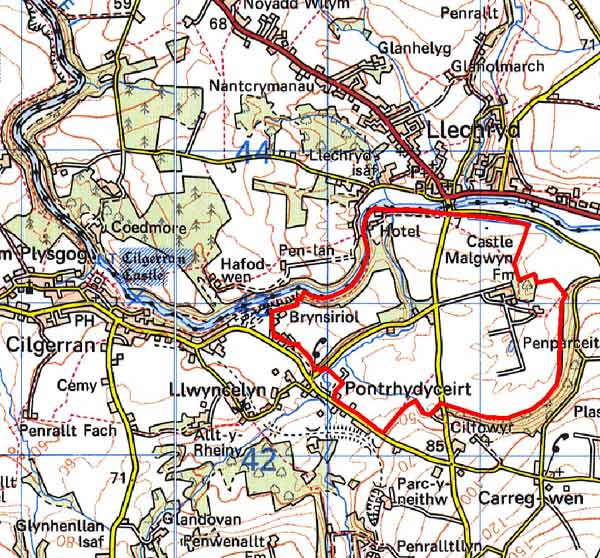
GRID REFERENCE: SN215428
AREA IN HECTARES: 173
Historic Background
A small area within modern Pembrokeshire corresponding to the late 18th - 19th century Castell Malgwyn Park and its environs, an estate landscape on the gently sloping ground south of the Afon Teifi.
This area lies within the medieval Cantref Emlyn, in Emlyn Is-Cych commote. Cantref Emlyn had been partly brought under Anglo-Norman control in c.1100 when Emlyn Is-Cych commote was reconstituted as the Lordship of Cilgerran. Cilgerran remained a marcher lordship, administered from Cilgerran Castle, which was established in c.1100. The lordship was regained by the Welsh in 1164 and remained under their rule until 1223. From 1339 it was held of the Earldom of Pembroke, which passed to the crown in the late 15th century. It was eventually abolished in 1536, when the lordship was incorporated into Pembrokeshire as the Hundred of Cilgerran. The medieval lordship, administered as a ‘Welshry’, remained subject to Welsh laws, customs and tenurial systems throughout the period. This - - with neither vills nor knight’s fees - has been largely responsible for the dispersed settlement within the region.
Although Castell Malgwyn has been regarded as the site of a medieval castle, this is unlikely. However, there is a strong tradition that it was a high-status house of the Welsh princes during the medieval period, and it was first recorded in c.1400 when it was held by a descendent of the legendary Cadifor Fawr of Blaen Cych. Earlier records refer to the original house, which is now a farmhouse on a high wooded bluff. The an extensive iron- and tinplate works was established at Penygored, on the banks of the Teifi, between 1764 and 1770. A canal (or leat) supplied water to the works, materials were brought up the navigable river and there was ample woodland on the valley sides for fuel. The works were successful, passing through several hands until they closed in 1806. Sir Benjamin Hammet, who had acquired the estate in 1792 when he purchased the Penygored Company, began the present Castell Malgwyn House, parks and gardens in 1798. This area is now characteristed by the park and gardens. Castell Malgwyn House is now a hotel.
Description and essential historic landscape components
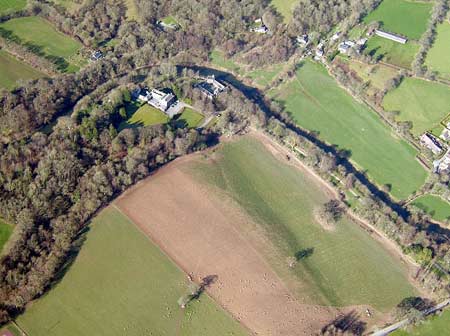
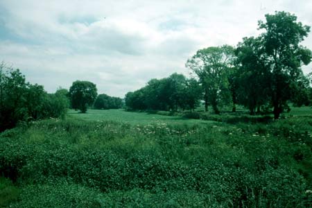
Castell Malgwyn is an estate dominated historic landscape character area lying on north-facing gently sloping ground rising from the Afon Teifi at less than 10m above sea level to 70m at its southern edge. It consists of the Castell Malgwyn mansion, parkland and associated land and buildings. The core of the estate consists of the three storey Georgian style house built in about 1795 of Teifi valley rubble slate and the nearby mid 19th century stable block and service wing of cut and coursed Teifi valley slate. The mansion is a hotel and the stable buildings and service buildings converted to tourist accommodation. A small park, entered through mid 19th century gates with flanking lodges of similar date, lies immediately to the east of the house, and wooded pleasure grounds flank the Afon Teifi to the north and west. Further out tree clumps indicate the former extent of the surrounding parkland, which is now subdivided by well-maintained hedges on earth banks into large regular fields. The home farm, consisting of a substantial late 18th century house with a very formal set of stone-built outbuildings, kitchen garden, other gardens and extensive modern agricultural outbuildings, lies in the parkland. The estate constructed other buildings, such as the mid 19th century Elizabethan timber frame style Mount Pleasant house. Nearly all the estate-constructed buildings are listed. An old stone built mill is located in this area. The only substantial modern building is a bungalow constructed in the former parkland close to the Castell Malgwyn entrance. Recorded archaeology is mostly related to the mansion and park; although two place-names possibly suggest Bronze Age round barrows which may indicate an extended human presence in the area. Two limekilns on the banks of the Teifi and a section of the canal/leat are the only surviving remains of an old tinplate and iron works.
This is a distinct historic landscape character area. The parkland and estate buildings distinguish it from the surrounding areas of farms and fields.
Sources: Brooke, E H, 1932, Monograph of Tinplate
Works in Great Britain, Swansea; Cadw – database of Building of
Special Architectural or Historic Interest; Cadw 2002, Register of Landscapes,
Parks and Gardens of Special Historic Interest in Wales, Part 1 Parks
and Gardens, Carmarthenshire, Ceredigion & Pembrokeshire; Cilgerran
parish tithe map 1844; Craster, O E, 1957, Cilgerran Castle, London; Fenton,
R., 1811 A Historical Tour through Pembrokeshire, London; Howell, D, 1987,
‘The Economy 1660-1793’, in D Howell Pembrokeshire County
History Volume III: Early Modern Pembrokeshire, 1536-1815, 299-332, Haverfordwest;
Jones, F, 1996, Historic Houses of Pembrokeshire and their Families, Newport;
Lewis, S, 1833, A Topographical Dictionary of Wales 1 & 2, London;
Manordeifi parish tithe map 1842; Owen, H (ed.), 1914, Calendar of Pembrokeshire
Records, 2, London; Rees, W, 1932, ‘Map of South Wales and the Border
in the XIVth century’; Rees, W, 1951, An Historical Atlas of Wales,
London; Regional Historic Environment Record housed with Dyfed Archaeological Trust
Base map reproduced from the OS map with the permission
of Ordnance Survey on behalf of The Controller of Her Majesty's Stationery
Office, © Crown Copyright 2001.
All rights reserved. Unauthorised reproduction infringes Crown Copyright
and may lead to prosecution or civil proceedings. Licence Number: GD272221