Home > Historic Landscapes > Black Mountain and Mynydd Myddfai > |

240 THE BLACK MOUNTAIN - Y MYNYDD
DDU 
GRID REFERENCE: SN 820228
AREA IN HECTARES: 14720.00
Historic Background
A character area which comprises the entire Black Mountain/Mynydd Myddfai/Mynydd
Bach massif. The majority of the area lay within Cwmwd Perfedd, of Cantref
Bychan, which retained native tenurial customs until the end of the Medieval
period when it was incorporated within modern Carmarthenshire, while the
easternmost section lay within the Lordship of Brycheiniog. It is now
unenclosed moorland and mountain which generally exhibits a hard boundary
with enclosed areas to the north, suggesting a long period of stability
- since the 16th century in parts (Leighton 1997, 29). However, both ad
hoc encroachment and parliamentary enclosure have occurred along its far
western edge. Much of the area comprises mountain which has never been
subject to intense human usage, but those areas of moorland which have
been exploited exhibit five main themes of land-use. Dominated by the
continuous upland pasturing of sheep, they include the removal of natural
woodland, which reached altitudes of 800 m, from the Mesolithic period
onwards; the occupation and partial enclosure of the landscape in the
prehistoric period, and contemporary ritual activity; some informal occupation
of the area, with longhuts, and its partial enclosure during the Post-Medieval
period; and 19th- and 20th-century leisure activities including field
sport (Leighton 1997). The northern part of the area exhibits a more complex
history. Here, Mynydd Myddfai is crossed by the Roman road from Llandovery
(Alabum) to Brecon (Cicutio), with the establishment of two successive,
superimposed marching camps at Y Pigwn. The road was later abandoned in
favour of the line of the present A40(T). A second marching camp site
lies on the moorland plateau at Arosfa Garreg to the south. Much of Mynydd
Myddfai once lay within Dôl Hywel grange, which had been granted to Talley
Abbey by 1324 (Ludlow 1998). It was an upland grange, probably operated
by tenant farmers primarily concerned with the mountain pasturing of animals,
and appears to have been largely unenclosed during the historic period,
as it is today. It was later exploited for tilestone and the line of quarries
following the outcrop were mainly operational in the 18th- and 19th-century.
Running from east-west alongside Arosfa Garreg is a drovers road from
Llangadog to Trecastle, beside which is a large turbary (peat-cutting)
from the Post-Medieval period. Further south, the existing mountain road
from Brynamman to Llangadog, which was a major Post-Medieval droving route,
was turnpiked from 1779. It was superseded by the present A4069 but still
survives as a track, the 'Bryn Road' (DAT & CPAT, 1997, 5). The eastern
edge of the area is characterised by a number of pillow-mounds which may
have early Post-Medieval origins, although rabbit farming was practised
in neighbouring areas to the east until the end of the 19th century.
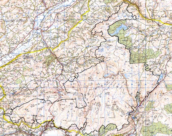
Base map reproduced from the OS map with
the permission of Ordnance Survey on behalf of The Controller of Her Majesty's
Stationery Office, © Crown Copyright 2001.
All rights reserved. Unauthorised reproduction infringes
Crown Copyright and may lead to prosecution or civil proceedings. Licence
Number: GD272221
Description and essential historic
landscape components
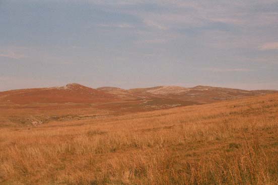
This extremely large character area comprises all of the Black Mountain/Mynydd
Myddfai/Mynydd Bach which lies outside Area 239. The whole area is unenclosed
moorland. It includes the high escarpment above Llyn y Fan Fach/Llyn y
Fan Fawr known as Bannau Sir Gar/Fan Brycheiniog which peaks at over 800
m. However, generally this area lies between 250 m and 600 m. The remains
of past human exploitation are slight but nevertheless distinctive. Bronze
Age burial mounds which cap the summits of most hills are the most obvious
ancient elements of the landscape, but there are numerous abandoned settlements
scattered across the mountain, mostly in valleys and at lower levels.
Most are probably Post-Medieval, but some may be earlier. They are sometimes
associated with old field systems and sheepfolds. Industrial remains are
also present: quarries and tramways. The A4069 road, and old turnpike,
crosses the mountain from north to south and links the industrial Amman
valley with limestone workings and the Tywi valley. Despite all these
remains, the landscape is one of open uninhabited moorland with rough
grazing at lower levels and blanket peats at higher elevations. An unusual
characteristic of this area is its very well-defined boundary with enclosed
farmland to the north. This seems to be old established boundary and is
marked on the ground for much of its course by a broken-down dry-stone
wall or a stony bank. To the west and east the boundary between the open
moorland of this area and enclosed farmland is not as hard-edged - former
encroachments have blurred the border.
Recorded archaeology is extensive and relates to the land-use outlined above, including Bronze Age hut platforms, stone circles, summit cairns and field systems, the Roman road and camps, early Post-Medieval longhuts and informal enclosures, contemporary turbaries, pillow-mounds, the tilestone quarries, and 19th- and 20th-century sporting and survey features.
There are no standing buildings.
This is a very distinctive area as it is bordered by enclosed farmland and forestry. Only to the north where it merges with a zone of industrial workings on the mountain are its boundaries indistinct.