Home > Historic Landscapes > Black Mountain and Mynydd Myddfai > |

239 BANC WERNWGAN - FOEL FRAITH QUARRIES

GRID REFERENCE: SN 721187
AREA IN HECTARES: 1378.00
Historic Background
An extremely large landscape area forming an east-west 'belt' on the northern
flank of the Black Mountain. It once lay within Maenor Gwynfe, Cwmwd Perfedd,
of Cantref Bychan which was invaded by the Anglo-Normans under Richard
Fitz Pons who established a caput at Llandovery in 1110-16 (Rees n.d.).
It was acquired soon after by the Clifford lords of Brecon as the Lordship
of Llandovery but later reverted to Welsh rule. From 1282 onwards the
lordship remained under English rule but retained native tenurial customs
until the end of the Medieval period when it was incorporated within modern
Carmarthenshire. During the Post-Medieval period was held by the Vaughans
of Golden Grove and the Earls of Cawdor (James n.d., 87). It is now unenclosed
moorland and mountain. The boundary between this area and the enclosed
Areas 233 and 255 to the north is long-established and defined by a masonry
wall and/or bank, suggesting a long period of stability - since the 16th
century in parts (Leighton 1997, 29) - with no evidence for ad hoc encroachments
or later parliamentary enclosure. The main themes in the history of land-use
within the area, dominated by former limestone quarrying and the continuous
upland pasturing of sheep, are the removal of natural woodland - which
reached altitudes of 800 m - from the Mesolithic period onwards; occupation
and partial enclosure of the landscape in the prehistoric period with
contemporary ritual activity; the informal occupation of the area, with
longhuts, and its partial enclosure during the Post-Medieval period; and
19th- and 20th-century leisure activities including field sport (Leighton
1997). Limeworking, which had been undertaken since at least the Medieval
period, intensified during the 18th- and early 19th-century and was joined
by quarrying for silica sand. These activities received impetus when an
existing mountain road and major Post-Medieval droving route was turnpiked
from 1779. This was superseded by the present A4069 but still survives
as a track, the 'Bryn Road' (DAT & CPAT, 1997, 5).
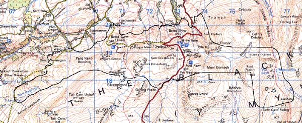
Base map reproduced from the OS map with
the permission of Ordnance Survey on behalf of The Controller of Her Majesty's
Stationery Office, © Crown Copyright 2001.
All rights reserved. Unauthorised reproduction infringes
Crown Copyright and may lead to prosecution or civil proceedings. Licence
Number: GD272221
Description and essential historic
landscape components
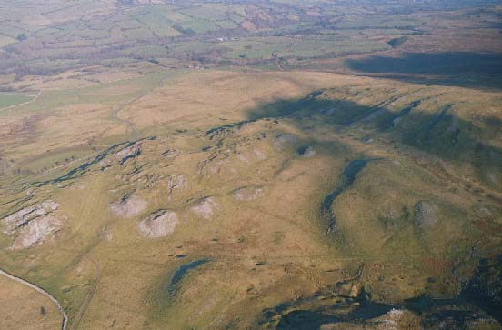
This area consists of that part of the Black Mountain which has Carboniferous
limestone geology and has been subjected to quarrying. It comprises north-facing
slopes on the northern fringes of the mountain between 300 m and 600 m.
The area is entirely unenclosed and given over to rough pasture and open
moorland, with blanket peats on higher ground and in hollows. The remains
of the limestone quarrying industry are ubiquitous and are the most obvious
elements of the historic landscape. Quarries and spoil heaps are the clearest
remains, but there are also numerous limekilns scattered across the landscape.
Also connected with the quarrying are the A4069 road and the 'Bryn Road',
originally constructed to serve the limestone industry.
Recorded archaeology is extensive and relates to the land-use outlined above, including Bronze Age hut platforms, summit cairns and field systems, early Post-Medieval longhuts and informal enclosures, limeworking features such as quarries, kilns and an extensive network of trackways, and 19th- and 20th-century sporting and survey features.
There are no standing buildings.
To the north this area is very well defined as it borders an area of stone-walled enclosures, and enclosed farmland. On other sides it merges with the larger portion of the Black Mountain.