Home > Historic Landscapes > Black Mountain and Mynydd Myddfai > |

236 PENTREGRONW 
GRID REFERENCE: SN 790279
AREA IN HECTARES: 36.42
Historic Background
A very small character area on the southwest slope of Mynydd Myddfai,
lying within the former Maenor Myddfai, Cwmwd Perfedd, of Cantref Bychan,
which was invaded by the Anglo-Normans under Richard Fitz Pons who established
a caput at Llandovery in 1110-16 (Rees n.d.). It later reverted to Welsh
rule, but from 1282 onwards the Lordship of Llandovery remained in English
hands, although it retained native tenurial customs until the end of the
Medieval period when it was incorporated within modern Carmarthenshire.
During the Post-Medieval period it was held by the Vaughans of Golden
Grove and the Earls of Cawdor (James n.d., 87). This character area is
a small area of enclosed land which forms a pocket projecting into the
otherwise unenclosed moorland of Mynydd Myddfai, and comprises 28 small,
irregular fields around the small homestead of Pentregronw, which is marked
and labelled on early 19th-century maps. The form of the enclosures suggests
late Medieval or Post-Medieval encroachment onto the unenclosed moorland.
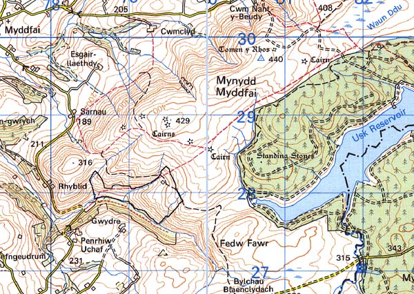
Base map reproduced from the OS map with
the permission of Ordnance Survey on behalf of The Controller of Her Majesty's
Stationery Office, © Crown Copyright 2001.
All rights reserved. Unauthorised reproduction infringes
Crown Copyright and may lead to prosecution or civil proceedings. Licence
Number: GD272221
Description and essential historic
landscape components
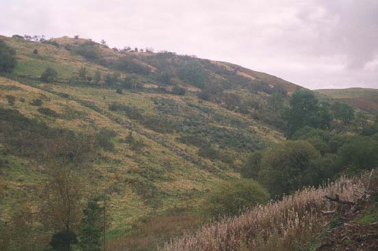
This small character area lies on a very steep southwest-facing slope
between 220 m and 340 m on the edge of Mynydd Myddfai. The area has been
enclosed into fairly regular small fields by a combination of dry-stone
walls, earth banks and stony banks. The banks were formerly topped with
hedges, but these are now either derelict or overgrown. The dry-stone
walls are in a decayed state. On lower, less steep slopes at the northwest
end improved pasture is present, which has been made stock-proof with
wire fences. Elsewhere boundaries have broken down and the land is reverting
to moorland. A single, deserted farmstead, Pentregronw, lies on the lower
slopes.
Recorded archaeology is confined to the small, stone-built farmstead, Pentregronw, which is of probable 19th century date, and a former adjacent cottage, neither of which are distinctive buildings.
This area is very well defined as it is bounded on three sides by unenclosed moorland of the Black Mountain, and on the fourth side by old established farms and fields.