Home > Historic Landscapes > Black Mountain and Mynydd Myddfai > |

233 LLANDDEUSANT - CAPEL-GWYNFE 
GRID REFERENCE: SN 761261
AREA IN HECTARES: 4778.00
Historic Background
A very large character area on the northwest fringes of the Black Mountain/Mynydd
Myddfai, lying within the former Cwmwd Perfedd of Cantref Bychan which
was invaded by the Anglo-Normans under Richard Fitz Pons who established
a caput at Llandovery in 1110-16 (Rees n.d.). It was acquired soon after
by the Clifford lords of Brecon as the Lordship of Llandovery but later
reverted to Welsh rule. In 1282 the Lordship was acquired by John Giffard
and thereafter remained under English rule (James n.d., 87) but retained
native tenurial customs until the end of the Medieval period when it was
incorporated within modern Carmarthenshire. The area has strong 'Celtic'
traditions - hagiographies suggest that St Paulinus, the reputed teacher
of St David established a monastic college in the general area, dedicated
to two saints (Sambrook and Page 1995, 4); the present dedication of Llanddeusant
parish church is to SS Simon & Jude but may reflect an earlier joint dedication
(Ludlow 1998). Capel Gwynfe has historically been a chapel-of-ease to
Llangadog parish, but a system of boundaries adjacent to the church may
perpetuate the line of a llan (Sambrook and Page 1995, 5). By the post-Conquest
period Area 233 was divided between the Medieval Maenor Llanddeusant,
coterminous with the ecclesiastical parish, and Maenor Gwynfe. The present
pattern of small, irregular fields may well be early in date, and represent
a system of small dispersed holdings that were well-established by the
time of the tithe surveys of the early 19th-century. Indeed, the physical
boundary between this area and the unenclosed moorland of Areas 239 and
240 to the south is well-defined as a masonry wall, suggesting a long
period of stability without evidence for ad hoc encroachments. During
the later Middle Ages the Lordship of Llandovery was held by the Audleys,
and in the Post-Medieval period by the Vaughans of Golden Grove and the
Earls of Cawdor (James n.d., 87). Both Coed Mawr and Llwynfron were recorded
as dwellings of the Aubrey family in the 16th century (Jones 1987, 40,
121), Pant Hywel, Penrhiw and Penycrug were residences of the Lewis family
(Jones 1987, 142) while the Lewis family of Gwynfe styled themselves 'Lords
of Gwynfe' (Jones 1987, 89-90). Nevertheless, the effects of gentrification
have been less extensive within this character area than is general within
the region and there is little parkland or 'polite' architecture. The
area includes a network of Post-Medieval drovers routes, the most important
of which followed the Sawdde Valley down from the Black Mountain to Llangadog;
the current A4069 partly follows a drovers road, the 'Bryn Road', turnpiked
from 1779 (DAT & CPAT, 1997, 5). The present nucleations are all late;
the development of Capel Gwynfe, for example, was concomitant on the establishment
of the turnpike running past the church which was rebuilt in c.1800 and
again in 1898 (Ludlow 1998). Llanddeusant Church never became a focus
for settlement, which instead developed around routeways, particularly
the crossroads at Twyn-llanan and at Cross Inn (the latter with an inn).
However, in all cases settlement is slight, and dispersed.
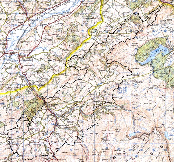
Base map reproduced from the OS map with
the permission of Ordnance Survey on behalf of The Controller of Her Majesty's
Stationery Office, © Crown Copyright 2001.
All rights reserved. Unauthorised reproduction infringes
Crown Copyright and may lead to prosecution or civil proceedings. Licence
Number: GD272221
Description and essential historic
landscape components
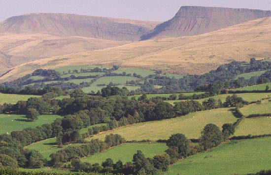
This is an extremely large character area. It runs for some 17 km southwest
to northeast along the northern side of the Black Mountain, and is up
to 5 km wide, southeast to northwest. It consists of rolling hills and
deeply incised narrow valleys, ranging in height from 120 m in the valley
bottoms to over 300 m on the summits of the higher hills and along the
fringes of the Black Mountain. The historic landscape comprises small
irregular fields, dispersed small farms and scattered woodland. The whole
area has been enclosed into a patchwork of small fields by earth banks
and hedges. Over such an extensive area there are clear differences of
hedge management, but generally hedges are in good condition and well
maintained, with derelict and overgrown examples usually occurring only
at higher altitudes and along the fringes of the Black Mountain. A striking
characteristic of this area is the very sharp boundary between it and
the unenclosed land of the Black Mountain. On the ground this boundary
is marked for at least part of its course by a dry-stone wall/stony bank.
Other stony banks rather than earth banks were also noted close to the
boundary of the Black Mountain, especially at the northeastern end of
the area. Land-use varies across the area, but is predominantly improved
pasture with pockets of rough grazing and rushy ground. Most of the steep
valley sides are cloaked with deciduous woodland. This together with distinctive
hedgerow trees in areas of overgrown hedges lends a wooded aspect to parts
of the landscape. A couple of small conifer plantations are present. Apart
from the A4069, the old turnpike road which runs south to north across
the area linking the south side of the Black Mountain with the Tywi valley,
transport links are confined to numerous local minor roads, lanes and
tracks. Settlement in the area comprises predominantly dispersed farms
and other dwellings. Farmhouses are mostly 19th century, stone-built,
two-storey, three-bays in the vernacular tradition. Traditional outbuildings
associated with the farms are also 19th century and stone-built, and tend
to be relatively small, often limited to just one range. Most farms have
a collection of modern agricultural buildings. Early 19th-century buildings,
including an old inn, in the polite 'Georgian' tradition are dispersed
close to New Inn on the A4069 old turnpike road. Capel Gwynfe and Twynllanan
are the only aggregate settlements in the area. Both are essentially hamlets,
comprising a loose cluster of 19th century houses focused on chapels,
with late 20th-century residential development in a variety of materials
and styles. Other 19th century chapels in the area stand in isolated locations,
as does the Medieval parish church of Llanddeusant. Outside the two hamlets,
other late 20th-century development is limited to occasional isolated
houses or bungalows.
Recorded archaeology from such a large landscape area takes in a range of sites from all periods. However, all features relate primarily to agricultural land-use.
There are a few distinctive buildings, but the older houses have mostly been rebuilt, and none are listed. Llwynfron, however, is a small gentry farmhouse with 17th century origins, Bedw-hirion is a similar house of 1796 and Ty Brych is a small farmhouse of the early 19th-century, all subject to consideration for relisting (Judith Alfrey, pers. comm.). SS Simon & Jude, Llanddeusant is a Grade B listed landmark Medieval church with a turret, while the unlisted Capel Gwynfe is from 1898-9, with a tower (Ludlow 1998) and an earlier 19th century church hall (formerly the church building).
The boundary wall between this area and Area 240 is distinctive but now derelict. The boundary of this area is very well defined against the Black Mountain to the south, and against a forestry plantation to the north. Elsewhere to the north between this area and its neighbours there tends to be a zone of change rather than a hard-edged border.