Home > Historic Landscapes > Black Mountain and Mynydd Myddfai > |

231 TRICHRUG 
GRID REFERENCE: SN 679222
AREA IN HECTARES: 786.10
Historic Background
A southwest - northeast ridge on the southeast side of the Tywi Valley.
During the historic period the area lay within Cantref Bychan, divided
between two commotes. The western half of the area lay within Iscennen
commote, specifically within Maenor Llys. Iscennen remained nominally
independent of Anglo-Norman rule until 1284 when it was acquired by John
Giffard, and in 1340 it became a member of the Duchy of Lancaster (Rees
1953, xv-xvi). The remainder of Cantref Bychan, including Cwmwd Perfedd
within which the remainder of this area lay, was invaded by the Anglo-Normans
under Richard Fitz Pons who established a caput at Llandovery in 1110-16
(Rees n.d.), and was acquired soon after by the Clifford lords of Brecon
as the Lordship of Llandovery. However, there were many episodes of Welsh
rule and the area retained native tenurial customs until the end of the
Medieval period when it was incorporated into modern Carmarthenshire.
The boundary between the two areas is still represented by a 'T'-junction
on the trackway that follows the spine of the ridge in the western half,
which is shown as a trackway on Rees' map of South Wales in the 14th century
(Rees 1932). Rees' map also labels this area 'Brenaye Forest', and indeed
it appears that the area was probably unenclosed land during the Medieval
period and later. The pattern of large, regular enclosures with straight
boundaries was in place by 1839 (Llangadog tithe map) but it had probably
been recently established; its morphology suggests late enclosure of former
moorland. Some subdivision had taken place by 1891 (Ordnance Survey 6"
First Edition). The area is dominated by its surviving prehistoric archaeology
which provides great time-depth. Sites include a group of Bronze Age round
barrows and a possible Iron Age hillfort. The higher ground within the
area is pitted with former quarries, presumably Post-Medieval. There has
been little recent development.
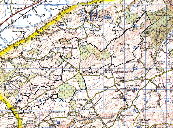
Base map reproduced from the OS map with
the permission of Ordnance Survey on behalf of The Controller of Her Majesty's
Stationery Office, © Crown Copyright 2001.
All rights reserved. Unauthorised reproduction infringes
Crown Copyright and may lead to prosecution or civil proceedings. Licence
Number: GD272221
Description and essential historic
landscape components
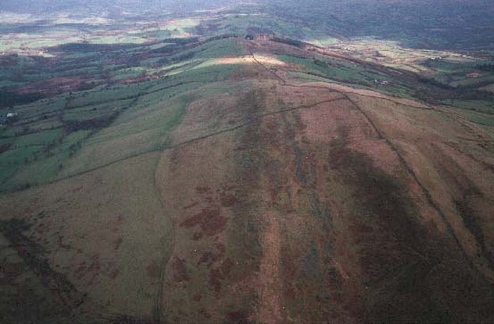
Trichrug character area lies across a southwest to northeast ridge. On
the flanks of the ridge this area runs down to about 200 m, the highest
summit achieved is over 400 m. The crest of the ridge rises from just
over 200 m in the southwest to the high point at the northeast end. The
whole ridge has been enclosed by medium- and large-sized regular enclosures,
but over much of the ridge crest, certainly at the highest point, these
have broken down, but on the flanks they survive though in a much degraded
form. Boundaries to the fields take a variety of forms, earth banks with
hedges, stony banks sometimes with hedges, and dry-stone walls. On the
ridge crest hedges are either gone or derelict, but elsewhere they are
in better condition, but generally overgrown. Nearly all the dry-stone
walls have collapsed. Wire fences provide stock-proof boundaries. At the
highest point the ridge essentially consists of a small area of unenclosed
moorland. Elsewhere rough pasture and improved grazing constitute the
main land-use, though several medium-sized conifer plantations are also
present. The remains of numerous small quarries along the ridge comprise
important landscape elements. Bronze Age burial mounds are also prominent
features of the landscape. There is little present settlement in this
character area. Recorded archaeology is rich and important, comprising
a Neolithic or Bronze Age findspot, a group of Bronze Age round barrows
and, on the edge of the area, a Bronze Age standing stone. There is also
an Iron Age or Roman findspot, a possible Iron Age hillfort, Post-Medieval
quarries and unknown enclosures .
There are few buildings and none are distinctive.
This is a very distinct area on account of its relative high altitude. Its boundaries, however, are not hard-edged, as the large enclosures of the ridge merge with the smaller fields of neighbouring richer farmland. To the east there is a clear boundary where this area borders forestry.