Home > Historic Landscapes > Black Mountain and Mynydd Myddfai > |

200 DAFADFA 
GRID REFERENCE: SN 690209
AREA IN HECTARES: 339.00
Historic Background
A discrete character area lying on the northwest
facing lower slopes of the Black Mountain, once part of Perfedd commote
of Cantref Bychan, which was invaded by the Anglo-Normans advancing from
the east under Richard Fitz Pons who established a caput at Llandovery
in 1110-16 (Rees n.d.). It was acquired soon after by the Clifford lords
of Brecon but was subject to episodes of Welsh rule until 1276 when it
was granted to the Gloucestershire knight John Giffard (Rees 1953, xv).
It retained native tenurial customs until the end of the Medieval period
by which time, at least, Perfedd was divided into two maenorau, this character
area lying within Maenor Gwynfe. The area appears to have comprised unenclosed
moorland, probably held as common or 'waste', until the Post-Medieval
period when the present pattern of relatively large, regular enclosures
was established. A sheepfold, in the north of the area, has given the
two farms Dafadfa Uchaf and Dafadfa Isaf their names and can therefore
be assumed to pre-date them; the farms were present by the early 19th-century
and are marked on the Ordnance Survey 1" Old Series. The landscape had
assumed its present form by 1839 (Llangadog tithe map) and there has been
little subsequent change.
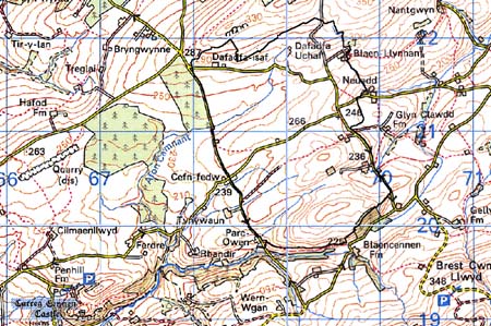
Base map reproduced from the OS map with
the permission of Ordnance Survey on behalf of The Controller of Her Majesty's
Stationery Office, © Crown Copyright 2001.
All rights reserved. Unauthorised reproduction infringes
Crown Copyright and may lead to prosecution or civil proceedings. Licence
Number: GD272221
Description and essential historic
landscape components
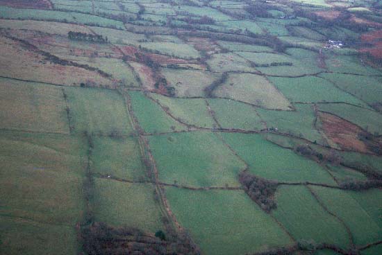
Dafadfa is a roughly rectangular character area which lies on a hilly
and undulating south-facing slope between the heights of 250m and 320m.
The land is entirely enclosed in a system of medium-sized fairly regular
enclosures. On lower slopes fields are small and tend to the irregular
rather than the regular; at higher levels they are larger and more regular.
Fields are divided by earth banks topped with hedges. At higher levels
hedges are becoming overgrown and neglected, with gaps opening in them,
but at lower levels they are generally well managed. Wire fences supplement
all hedges. Distinctive hedgerow trees are rare, and woodland is confined
to a couple of small secondary copses and plantations on the lower slopes.
Land-use is almost entirely improved pasture, with a little rougher, rushy
ground. The settlement pattern is of widely dispersed farms and, overall,
the enclosure- and settlement pattern indicates a landscape that has only
been colonised in relatively recent times, perhaps the 18th century.
Recorded archaeology is limited to the sheepfold and a Bronze Age burnt mound.
Farmhouses are stone-built with slate roofs, date to the 19th century and are in the vernacular tradition. Stone outbuildings are also 19th century and are relatively small. Most farms have large modern agricultural buildings associated with them. There is also a 19th century chapel.
This is a distinct character area. It contrasts with the areas to the south, west and east which contain smaller irregular fields, woodland and a denser but nevertheless dispersed settlement pattern, and with the areas to the north, northeast and northwest which have a looser enclosure and settlement pattern.