Home > Historic Landscapes > Black Mountain and Mynydd Myddfai > |

199 BEDDAU Y DERWYDDON 
GRID REFERENCE: SN 677182
AREA IN HECTARES: 37.60
Historic Background
A small character area represented by a limestone,
dry-stone walled enclosure measuring 400 m north-south by 1000 m east-west,
occupying the junction of enclosed farmland and unenclosed moorland of
the Black Mountain. The area was once part of Maenor Llys which occupied
the eastern part of Iscennen commote. Iscennen, unlike the rest of Cantref
Bychan within which it lay, remained nominally independent of Anglo-Norman
rule and held under native tenurial systems until 1284 when it was acquired
by John Giffard. In 1340 it became a member of the Duchy of Lancaster
(Rees 1953, xv-xvi). The enclosure is probably later Medieval/early Post-Medieval
in origin and enclosing moorland that had probably been former common
grazing. Within the enclosure are a large number of pillow-mounds, probably
contemporary with the enclosure and representing a rabbit-warren associated
with either Cwrtbrynbeirdd or Carreg Cennen grange (Area 197), Iscennen
maerdref (Area 198) or Carreg Cennen Castle (Area 256) - the name Pâl-y-cwrt
occurring within the area suggests the former. The wall and pillow-mounds
are disused, but survive. Subsequent activity has mainly comprised limestone
extraction and processing.
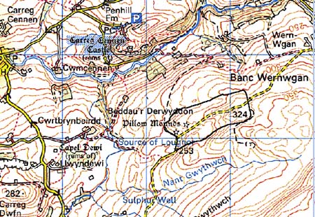
Base map reproduced from the OS map with
the permission of Ordnance Survey on behalf of The Controller of Her Majesty's
Stationery Office, © Crown Copyright 2001.
All rights reserved. Unauthorised reproduction infringes
Crown Copyright and may lead to prosecution or civil proceedings. Licence
Number: GD272221
Description and essential historic
landscape components
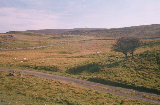
Beddau y Derwyddon character area lies on the northern slopes of the Black
Mountain at a height of approximately 320 m, comprising enclosed moorland
and rocky limestone outcrops. The dry-stone enclosure wall is in a fair
state of repair for most of its course. Most of the land is under rough
grazing, but in recent years sub-division of the lower, northern parts
by wire fences has been accompanied by pasture improvement. A single-track
road crosses the area alongside which are the remains of earth-and-stone
built lime kilns. There are no buildings, but concrete platform foundations
indicate that some form of structure recently stood by the road.
Recorded archaeology includes the wall, lime-kilns and building sites mentioned above, and the pillow-mounds which are a Scheduled Ancient Monument. In addition are several possible Bronze Age round barrows/clearance cairns, and a subsidiary enclosure of unknown nature.
There are no further buildings.
The area is well defined by the stone wall which surrounds it, and stands in sharp contrast with the open moorland to the south, and farmland enclosed by earth banks and hedges to the north.