Home > Historic Landscapes > Black Mountain and Mynydd Myddfai > |

198 UPPER CENNEN 
GRID REFERENCE: SN 683193
AREA IN HECTARES: 246.20
Historic Background
A small character area occupying the upper valley of the Afon Cennen within
the foothills of the Black Mountain, once part of Maenor Llys which occupied
the eastern part of Iscennen commote. Iscennen, unlike the rest of Cantref
Bychan within which it lay, remained nominally independent of Anglo-Norman
rule and held under native tenurial systems until 1284 when it was acquired
by John Giffard. In 1340 it became a member of the Duchy of Lancaster
(Rees 1953, xv-xvi). Area 198 lies at the political centre of the commote,
represented by the farm-names Ferdre Fawr and Fach, which represent the
former maerdref estates of Carreg Cennen Castle and llys (Area 256). Here,
by 1284 at least, a small estate was worked by 13 bond tenants who were
in the charge of a reeve, subject to its own legal court and responsible
for the maintenance of the lord's mill, labour and the carriage of produce.
They held their land by inheritance, with perpetual right to their holdings
(Rees, 1924, 200), while they also paid rent on Pedol (Area 240) and other
holdings within the Black Mountains which may indicate that they were
responsible for the summer pasturing of the lord's livestock (Sambrook
and Page 1995, 14). The adjacent farm-name 'Rhandir' records the shareland
process. After 1284, the bondmen petitioned the crown for maintenance
of their rights to farm their hereditary lands. The estate may, nevertheless,
have contracted into the present pair of farms at an early date. The pattern
of enclosures presumably belongs to a post-shareland transitional phase;
the irregular nature of the fields and their small size suggests, however,
that they are not late creations. The present landscape was in place by
at least 1839, when the tithe map for Llangadog parish was drawn up.
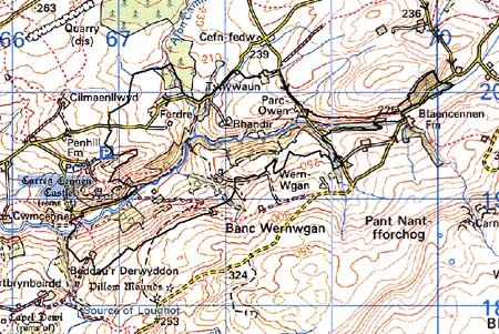
Base map reproduced from the OS map with
the permission of Ordnance Survey on behalf of The Controller of Her Majesty's
Stationery Office, © Crown Copyright 2001.
All rights reserved. Unauthorised reproduction infringes
Crown Copyright and may lead to prosecution or civil proceedings. Licence
Number: GD272221
Description and essential historic
landscape components
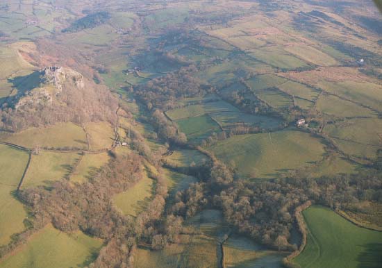
The Upper Cennen character area consists of the deeply incised Cennen
valley and its tributaries. The valley bottom lies at approximately 150
m, the sides rise to over 200 m. On the south side the valley sides are
steep, parts of those on the northern side are precipitous. The valley
sides are heavily cloaked in deciduous woodland. The land lies under improved
pasture which has been divided into small irregular fields by earth banks
and hedges. Hedges are generally in good condition, and well maintained,
though there is some neglect and dereliction; wire fences supplement all
hedged boundaries. Farmsteads dispersed across the landscape provide the
settlement pattern and are generally 19th century in date, vernacular
and informal.
There is very little recorded archaeology in what is a small character area, being restricted to two earthworks of unknown nature, a Bronze Age findspot and a possible well site.
There are no distinctive buildings. Farmhouses are generally 19th century in date, stone-built with slate roofs, of two-storeys and three bays, and in the vernacular tradition. Associated old farm buildings are stone-built and again of 19th century date, relatively small and usually in an informal arrangement with the farmhouse.
Though this is geographically a distinct area, its historic components are shared with neighbouring areas and therefore its boundaries tend to be a zone of transition, rather than a hard-edged border. Carreg Cennen Castle character area is an exception as a clear boundary exists here.