Home > Historic Landscape Characterisation > Upland Ceredigion > |

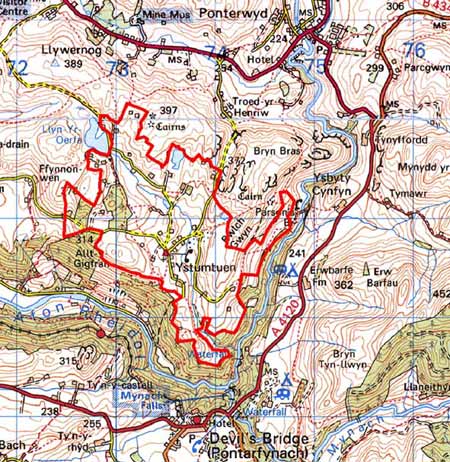
 YSTUMTUEN
GRID REFERENCE: SN 736788
AREA IN HECTARES: 241.2
Historic Background
The early history of this area is not clear. In the
Medieval Period it lay between Strata Florida Abbey’s grange of
Cmwystwyth and Cwm-hir’s Nantyarian grange. In more recent times
it became a possession of the Nanteos estate. In 1690 a document lists
the farms of Pantgwyn Issa, Pantgwyn Ycha, Penygareg, Plwcca Bydr, Penrhiwgam,
Tir y Castell and Nantgoredyn as all belonging to Nanteos in Ystumtuen
(Griffiths 1988, 5). Lewis Morris’s 1744 map of the area shows about
a dozen small farms. Interestingly he shows the enclosed land separated
from unenclosed by a ‘Mountain Hedge’. Late 18th and early
19th century estate maps (NLW Vol 45, 21-23 & 35; Vol 37, 37, 62)
show the area in greater detail than the Lewis Morris map. Farms are small
and consist of one or two small paddocks or fields around a farmstead,
set in a large enclosure or unenclosed land - it is not clear which from
the maps - on the fringes of sheep-walk. Some farms such as Lluestwen
have no enclosed land and simply lie within moorland. Lewis Morris also
noted lead mines in this area; some of these are shown on the estate maps.
This was an important mining area, working from at least the early 18th
century, including the mines of Ystumtuen, Tynyfron, Penrhiw, Bwlch-gwyn
and Llwynteifi (Bick 1983, 21-26). By the tithe survey further settlements
had developed; some of these were on the fringes of marginal land and
were undoubtedly squatter settlements. Throughout the first half of the
19th century the population continued to grow in conjunction with an increase
in lead mining. A loosely nucleated hamlet - Ystumtuen - developed with
a chapel, school and a number of dispersed cottages. Although the population
declined towards the end of the 19th century, there were 60 houses occupied
in 1907. The demise of the lead mining industry in the early decades of
the 20th century hastened migration from Ystumtuen. By 1988
36 houses were in occupation, of which 12 were holiday homes (Griffiths
1988, 79).
Description and essential historic landscape components
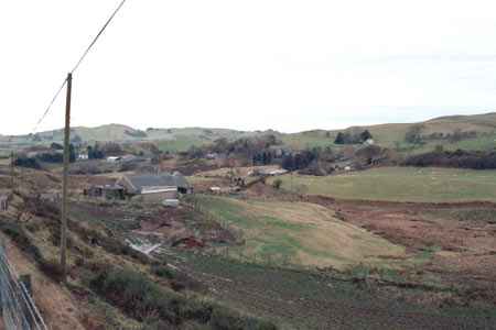
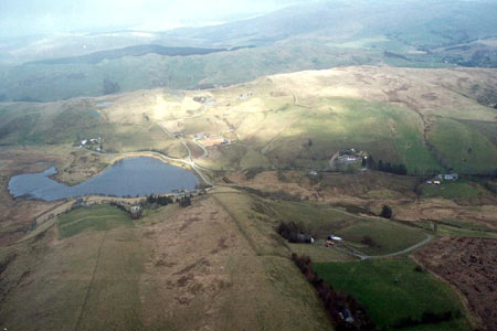
This area consists of an undulating and craggy block of land sandwiched between the steep-sided valley of the Rheidol to the south and east, and high, open moorland to the north. Heights vary considerably from 270m at the areas southern limits to almost 400m in the north. Access to the area is only possibly via single-track roads over the high moorland to the north. No road leads down into the Rheidol valley. The historic landscape consists of dispersed farms, houses and cottages with a loose cluster of buildings at Ystumtuen hamlet, set within a patchwork of small, irregular enclosures (some of which are of improved pasture), unenclosed craggy slopes and summits, peaty hollows, spoil heaps and old buildings of the lead mining industry, and small reservoirs built to serve the mines. Earth and stone banks divide the enclosures. Hedges are now rare apart from those on the lower slopes to the south and east, but even here they are becoming overgrown and derelict and are supplemented by wire. Elsewhere wire fences are the main stock proof barriers.
Local stone is the traditional building material with slate (north Wales slate) used for roofs. Walls are either cement rendered or left bare on houses, and always bare on traditional farm buildings. There is a mixture of agricultural holding and industrial housing. Older farmhouses/houses almost entirely date to the mid-to-late 19th century, are relatively small, of two storeys and in the typical Georgian vernacular style. On farms this consists of gable end chimneys, a central front door, and two windows either side of the door and one above. Industrial houses are smaller. Vernacular traits such as low eaves, small windows and one chimney larger than the other are present on most houses. Stone-built outbuildings are generally confined to one or two small ranges, with some attached and in-line to the house. Working farms have small ranges of modern steel and concrete agricultural buildings. There are several modern houses/bungalows in the area, and some of the older houses have been extensively modernised and extended.
The remains of the lead mining industry are ever-present. Spoil heaps are the most obvious reminder of the industry, but old stone buildings comprise a distinct and important component of the historic landscape. The mine buildings are beginning to deteriorate; some spoil heaps have been quarried to provide hard-core.
Recorded archaeology in this area consists almost entirely of remains of the metal mining industry or of post-Medieval deserted settlements.
This is distinct landscape area with a clear boundary between it and its neighbours. To the south and east is the heavily wooded valley of the Rheidol. Unenclosed moorland lies to the north, and more fertile, less undulating and craggy land to the west.
Base map reproduced from the OS map with the permission
of Ordnance Survey on behalf of The Controller of Her Majesty's Stationery
Office, © Crown Copyright 2001.
All rights reserved. Unauthorised reproduction infringes Crown Copyright
and may lead to prosecution or civil proceedings. Licence Number: GD272221