Home > Historic Landscape Characterisation > Upland Ceredigion > |

 YSTRAD CARON
GRID REFERENCE: SN 674603
AREA IN HECTARES: 273.4
Historic Background
This area of river terrace to the west of Tregaron probably comprised lands granted to the town of Tregaron and functioned either as a sub-divided field or common, although no research has been undertaken to substantiate this. By the late 18th century the land had been divided between several large estates: Nanteos, Crosswood and Thomas Johnes’s Llanfair Clydogau estate. For the sake of clarity it is easier to break down the description of this area into smaller areas based broadly on farm boundaries.
An 1819 estate map (NLW Vol 45; 54) shows the farmhouse of Ystrad Caron with one small field, set in unenclosed land labelled ‘Ystrad’. Within this unenclosed land a few small enclosures are shown close to the river to the south of Ystrad Caron. They belong to several different holdings.
East of Tregaron the land in 1819 is shown parcelled up into the system of regular enclosures that now exist. A further map of 1819 (NLW Vol 45; 56) demonstrates that the system of regular fields to the north of the town had been laid out by this date, and that further subdivision of these large enclosures took place in the 19th century.
To the north on the fringes of Cors Caron a pattern of enclosure had been firmly established by 1808 (NLW Nanteos 216). An estate map of 1791 (NLW Vol 36; 147) indicates that a boundary on the fringes of Cors Caron had been newly laid out. However, it is difficult to reconcile this boundary with the modern landscape.
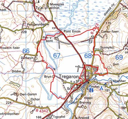
The same map (NLW Vol 36; 147) shows Pen-y-bont farm surrounded by small, irregular enclosures with the current pattern of regular, larger fields further out.
By 1845 (Caron Tithe Map and Apportionment) the field system now in existence across the whole of this landscape area had been finalised.
Estate map evidence and the pattern of regular medium-sized fields suggest that this area was largely unenclosed until the 18th century, and was only fully enclosed during the early to mid 19th century. The presence of a relatively large block of unenclosed, rich, level farmland on the outskirts of Tregaron, at least until 1819, is not easy to explain. It may have been common that had been acquired by the Nanteos estate and subsequently enclosed, or possibly a former sub-divided field system that had been engrossed into a few holdings, but not enclosed until the 18th century. Pen-y-bont farm is clearly of greater antiquity, the present building dates to the first half of the 17th century (Lloyd-Johnes 1952-55, 170), but whether it originated in the 16th century or is older is not known. It is a substantial farm that was originally part of the Herbert estate (the Herberts of Powis Castle rapaciously acquired properties in Ceredigion in the 16th century). It passed into the hands of Thomas Johnes and was the home of John Jones, Thomas Johnes’s Hafod agent in the 18th century (Rees 1936, 54).
Description and essential historic landscape components
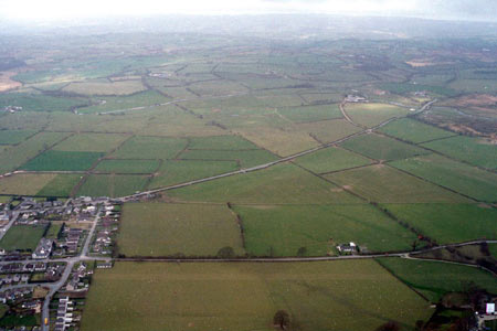
This is a block of regular, medium-sized enclosures on a trrace of the Afon Caron and Afon Teifi, to the east and north of Tregaron , between 160 to 170m. Improved pasture dominates, with virtually no unimproved land or rough grazing. Earth banks topped by hedges divide the fields. On the western side of the area the hedges are in good condition and well maintained, but towards the north eastern side the hedges are in poorer condition and are even derelict, and wire fences have replaced them. Here the earth banks are also less substantial than to the west. The farmhouse of Pen-y-bont is a three storey, stone-built, stucco Georgian building probably dating to the late 18th and early 19th century, but perhaps incorporating earlier elements. It is one of the largest farmhouses in upland Ceredigion. It has a wide range of traditional stone-built outbuildings and large modern agricultural buildings. The other major farm in this area also has extensive farm buildings. An old railway line - the Milford Manchester Railway of 1866 - runs across the western side of this area from north to south.
The recorded archaeology comprises standing buildings.
This landscape area is delineated by clear boundaries except to the northwest. To the north is Cors Caron/Tregaron Bog, Tregaron town lies to the southwest, and the Afon Teifi to the west. On its northwestern side this area gradually merges with its neighbouring area.
Base map reproduced from the OS map with the permission
of Ordnance Survey on behalf of The Controller of Her Majesty's Stationery
Office, © Crown Copyright 2001.
All rights reserved. Unauthorised reproduction infringes Crown Copyright
and may lead to prosecution or civil proceedings. Licence Number: GD272221