Home > Historic Landscape Characterisation > Upland Ceredigion > |

 WENALLT
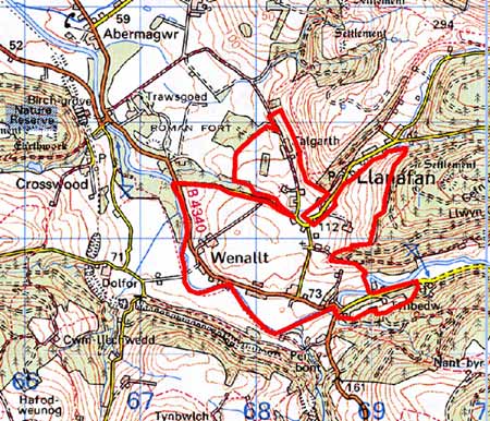
GRID REFERENCE: SN 683721
AREA IN HECTARES: 204.6
Historic Background
The history of this area is not entirely clear. It is likely that the settlement pattern is quite ancient and was in existence in the 16th century, when Morris ap Richard was busily acquiring farms and land to add to the embryonic Trawscoed (Crosswood) estate. Certainly by 1756 part of this area was firmly under the control of Crosswood as it formed part of its demesne lands (NLW Map 7188). Other holdings are recorded as part of the estate by the late 18th century, but were probably purchased much earlier. Estate maps of 1781 (NLW Crosswood Vol 1, 42, 43, 53, 55; NLW Gogerddan 54, 55) show a landscape that is clearly recognisable today, with dispersed farms set in a landscape of small irregular enclosures, although there have been some minor changes. For instance, in 1781, land to the east of Plas y Wenallt was unenclosed and named ‘Bank’. It was divided into medium-sized, regular fields by the tithe survey (Llanafan tithe map and apportionment 1845). It is not clear whether the enclosed field system evolved from a sub-divided system or represents an ancient enclosure pattern.
In the 1760s the Crosswood estate closed down its smaller mills and concentrated production at a new mill at Wenallt (Macve 1998, 62). A chapel was built in 1787, and a school in the early years of the 20th century (Percival 1998, 514).
Description and essential historic landscape components
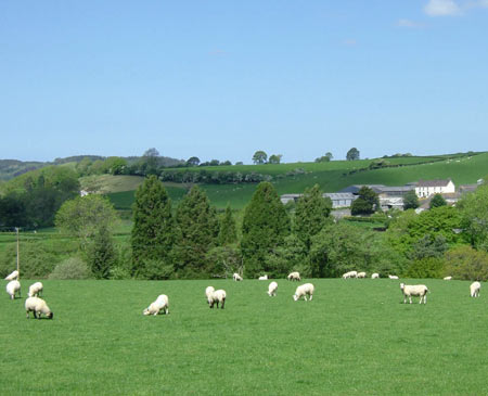
This area comprises a river terrace on the north bank of the Ystwyth between 70m and 120m, with land climbing at its eastern end to 200m. The field pattern consists of small- to medium-sized fields. There is no unenclosed land, and almost all farmland consists of improved grazing. Earth banks topped with hedges comprise the boundaries. Hedges have occasional distinctive trees. Most hedges are in good condition and are well maintained, though some are starting to be neglected. All are supplemented with wire. Occasional planted trees and shrubs give a parkland feel to parts of this landscape.
The settlement pattern is one of dispersed farms and houses, with dispersed, linear development along the main road through this area. This latter settlement type is probably an estate creation. Indeed, most buildings are probably of estate origin or estate influenced. Stone is the principal traditional building material – either left bare or cement rendered – with slate for roofs. Most buildings date to the mid or late 19th century. However, an exception is the listed Georgian style gentry house of Plas y Wenallt, built for the Trawscoed estate in the late 18th century, but possibly with earlier origins. A lodge and a cottage are later, but clearly estate built. Farmhouses and other houses are less obviously estate influenced and generally date to the mid –to-late 19th century and are in the regional Georgian vernacular tradition. Traditional farm buildings are relatively large, with examples of several ranges set formally around a yard in a typical estate layout. Modern agricultural buildings on working farms are also large. There is a small group of mid 20th century estate houses and a few late 20th century houses and bungalows. Other buildings include the listed single arch Pont Llanafan and a 19th century chapel.
The recorded archaeology of this area is not diverse, and consists of post-Medieval sites: a chapel, bridges and mills.
To the east, forestry provides a clear border to this
area. Elsewhere it has not been possible to provide a clear demarcation
between this area and Llanafan village to the north, and between the altered
parkland landscape of Crosswood to the northeast.
Base map reproduced from the OS map with the permission
of Ordnance Survey on behalf of The Controller of Her Majesty's Stationery
Office, © Crown Copyright 2001.
All rights reserved. Unauthorised reproduction infringes Crown Copyright
and may lead to prosecution or civil proceedings. Licence Number: GD272221