Home > Historic Landscape Characterisation > Upland Ceredigion > |

 WAUN WYDDYL
GRID REFERENCE: SN 669874
AREA IN HECTARES: 385.4
Historic Background
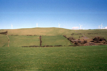
The history of this small upland area has not been researched. On the tithe map (Llanfihangel Geneu’r glyn, 1847) it is shown unenclosed, and was probably considered Crown land, a situation that is likely to have prevailed for several centuries prior to 1847. In the second half of the 19th century the area was divided into very large fields. A wind farm has now been established here.
Description and essential historic landscape components
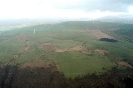
This area consists of a rounded hill, which achieves heights of over 340m. Generally the hillsides run down to 250m, but some of the steeper lower slopes descend to less than 150m. Formerly it was divided into large fields by earth banks - there are no hedges present now, though gorse bushes grow on some banks - but these are now largely redundant and wire fences now provide stock-proof boundaries. Improved grazing dominates, but rushy and peaty hollows are present as well as rough grazing and bracken on the steeper slopes. There are no inhabited settlements. A short-lived (opened 1897) railway/tramway traverses the lower northern slopes. A wind farm has recently been constructed on the crest of the hill.
The recorded archaeology is dominated by the remains
of minor metal mines on the northern flanks and summit of the area. An
impressive Iron Age fort, Pen Dinas, two possible Bronze Age round barrows
and two possible Bronze Age standing stones provide time-depth to this
landscape.
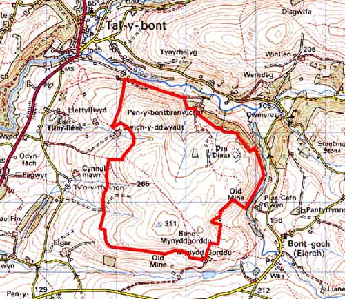
Base map reproduced from the OS map with the permission
of Ordnance Survey on behalf of The Controller of Her Majesty's Stationery
Office, © Crown Copyright 2001.
All rights reserved. Unauthorised reproduction infringes Crown Copyright
and may lead to prosecution or civil proceedings. Licence Number: GD272221