Home > Historic Landscape Characterisation > Upland Ceredigion > |

 TY’N-Y-CASTELL
GRID REFERENCE: SN 725773
AREA IN HECTARES: 26.6
Historic Background
As with surrounding landscape areas the early history of this area has not been researched, but by the 18th century it was in the possession of the Nanteos estate. An estate map of 1819 (NLW Vol 45, 31), showing Tn’n-y-castell and Faen Grach, depicts a landscape of small fields with some intermixing of land. This latter piece of evidence is of interest and suggests that the landscape may have evolved from a sub-divided, or open, field system; a system that was in the final stages of consolidation and enclosure in the early 19th century. Apart from the consolidation of intermixed lands, this landscape has not changed dramatically since the survey for the estate map.
Description and essential historic landscape components
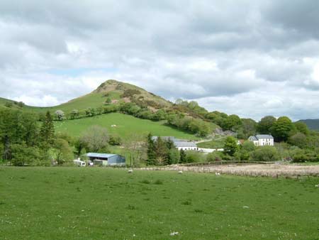
This small landscape area lies in a sheltered hollow on the edge of a plateau at c. 250m above the valley of the Afon Rheidol. It is characterised by a system of small irregular fields of improved pasture that are divided by earth banks and hedges. Unlike neighbouring landscape areas the hedges in this area are intact, and though overgrown they are still stock-proof when augmented by wire fences. The hedges, together with occasional hedgerow trees and small stands of deciduous woodland, lend a wooded appearance to the landscape that contrasts with areas to the south.
A fairly dense grouping of farms and other houses characterise the settlement pattern. Cement rendered stone with slate roofs are the traditional building materials. Most houses date to the mid-to-late 19th century, are relatively small, of two storeys and in the typical Georgian vernacular style – gable end chimneys, central front door, and two windows either side of the door and one above. Some houses have been extensively modernised and extended or rebuilt. There is also at least one modern house and an early 20th century corrugated iron (tin) cottage. Farms have two to three ranges of stone-built outbuildings and small modern agricultural buildings.
A disused stone quarry lies in this area.
This is a distinct historic landscape area, and is in
sharp contrast with areas to the south, which are generally treeless and
bereft of hedges. To the north lies the steep and heavily wooded valley
side of the Rheidol.
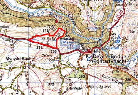
Base map reproduced from the OS map with the permission
of Ordnance Survey on behalf of The Controller of Her Majesty's Stationery
Office, © Crown Copyright 2001.
All rights reserved. Unauthorised reproduction infringes Crown Copyright
and may lead to prosecution or civil proceedings. Licence Number: GD272221