Home > Historic Landscape Characterisation > Upland Ceredigion > |

 TYNGRAIG
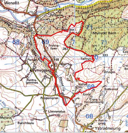
GRID REFERENCE: SN 697697
AREA IN HECTARES: 257.5
Historic Background
In the Medieval Period this area lay within Strata Florida Abbey’s Mefenydd Grange. At the Dissolution the abbey’s granges were granted to the Earl of Essex who subsequently sold them to the Crosswood (Trawscoed) estate in 1630. Most of the land in this area seems to have remained in the Crosswood estate through to the 20th century. In common with other granges, it is likely that by the end of the Medieval Period, if not earlier, Mefenydd had been divided into farms which were leased out and farmed on a commercial basis. Hafod place-names - Hafod-y-gofiant - suggest that these farms may have originated out of a system of transhumance. By the mid 19th century, at the time of the tithe survey (Gwnnws Tithe Map and Apportionment, 1847) the landscape had achieved much of its present-day appearance; the field system had been laid out and the settlement pattern established. Earlier maps of the late 18th century (NLW Crosswood Vol 1, 55, 58) show a landscape in the process of developing, with Nant-byr isaf and Nant-byr uchaf farms shown encroaching onto unenclosed land to the north. It is possible that both these farms were squatter settlements. On lower ground, Trgfriw-fawr farm’s enclosure pattern was established by the late 18th century, though further subdivision of larger fields occurred in the 19th century. The hamlet of Tyngraig developed in the 19th century, given impetus no-doubt by the opening of the Milford-Manchester railway through this area in 1866. A chapel was built here in 1869.
Description and essential historic landscape components
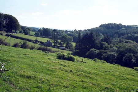
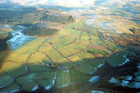
Centred on the upper, open valley of the north-flowing Sychnant, this area rises from 150m in the valley bottom to 350m on the eastern valley sides. Valley sides are mostly gently sloping, but some steeper slopes are present in the north. Included in this area is the hamlet of Tyngraig, but generally the settlement pattern is of scattered farms set in field systems of small, irregular enclosures. Boundaries comprise dry-stone walls, stony banks topped with hedges or stone-faced banks with hedges. On the lower levels hedges are generally in fair to good condition and are stock-proof. The higher up the valley side they are, the more derelict the hedges become. Wire fences have replaced hedges at the highest levels, and even at low levels wire fences are present along some of the hedges and walls. Land-use is predominantly improved grazing, though a few fields of arable are present. There are some moderately large stands of broadleaf trees and some small coniferous plantations. An unenclosed peat bog lies in the valley bottom towards the upper reaches of the Sychnant.
A few modern houses form a loose linear cluster along the main road through this area. Apart from these the building stock is almost entirely 19th century in date, stone-built with slate roofs. The walls on many of the buildings are left bare, indicating a readily available supply of good quality stone, but some houses are cement rendered. Houses, including farmhouses, are in the typical mid-to-late 19th century Georgian vernacular style, with two storeys, gable end chimneys, a central front door, and two windows either side of the door and one above. A strong Georgian tradition is evident in several; particularly the larger farmhouses, but many smaller houses and cottages have vernacular traits, such as the listed example of Rhydgaled. Stone-built farm outbuildings are generally relatively large for the region, with some farms having several ranges set semi-formally around a yard. Some of these old buildings are no longer in use. Working farms have small- to medium-sized modern agricultural outbuildings.
The recorded archaeology in this area mostly comprises post-Medieval sites. These include a small metal mine, extant buildings such as a chapel and cottages, deserted cottages on higher ground and a smithy. An earthwork that may be an Iron Age enclosure, and a possible Bronze Age standing stone provide a time-depth element to the landscape.
To the north this area is defined by a 20th century forestry plantation and to the east by unenclosed and semi-enclosed higher ground. Small but characteristically distinct areas of enclosures lie to the south. Landscape character areas have yet to be defined to the west.
Base map reproduced from the OS map with the permission
of Ordnance Survey on behalf of The Controller of Her Majesty's Stationery
Office, © Crown Copyright 2001.
All rights reserved. Unauthorised reproduction infringes Crown Copyright
and may lead to prosecution or civil proceedings. Licence Number: GD272221