Home > Historic Landscape Characterisation > Upland Ceredigion > |

 TYNDDOL
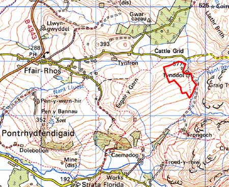
GRID REFERENCE: SN 765676
AREA IN HECTARES: 19.2
Historic Background
In the Medieval Period this area formed part of Strata Florida Abbey’s Mefenydd Grange. At the Dissolution the Earl of Essex was granted numerous abbey lands, the greater portion of which was purchased by the Crosswood estate in 1630, including land close to this area. The history of this small block of land is uncertain, though its upland nature may have ensured that it was considered unenclosed Crown land. It came to the interest of the Crosswood estate in the early 19th century when a large area, including this unit, was earmarked for Parliamentary Enclosure, and surveyed in 1815 (NLW Crosswood 347) for that purpose. The enclosure act was never awarded. By the tithe survey (Gwnnws Tithe Map and Apportionment, 1847) the area of Tynddol farm is shown as small enclosures set amongst larger enclosures.
Description and essential historic landscape components
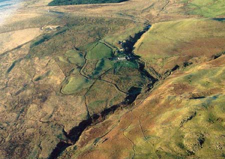
This is a small area of upland enclosure centred on the farm of Tynddol, between 300m and 370m. It is sandwiched between large enclosures of rough grazing to the west and unenclosed upland to the east. Enclosures are small and irregular and divided by earth banks topped with wire fences. There are no hedges. The farm is stone-built with a slate roof, and surrounded by very extensive modern farm buildings. Most of the enclosures consist of improved pasture, with patches of rougher grazing.
There are no recorded archaeological sites in the area.
The border of this area is well defined with unenclosed upland to the east, and large enclosures of rough grazing to the west, north and south.
Base map reproduced from the OS map with the permission
of Ordnance Survey on behalf of The Controller of Her Majesty's Stationery
Office, © Crown Copyright 2001.
All rights reserved. Unauthorised reproduction infringes Crown Copyright
and may lead to prosecution or civil proceedings. Licence Number: GD272221