Home > Historic Landscape Characterisation > Upland Ceredigion > |

 TREGARON
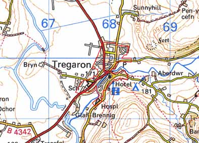
GRID REFERENCE: SN 679597
AREA IN HECTARES: 37.1
Historic Background
The dedication of the church to Caron, the presence of three early Christian monuments and a circular churchyard indicate an early foundation for Tregaron Church (Ludlow 1998). The church may have encouraged the development of a small settlement in the pre Anglo-Norman period. In 1290, Edward I granted to Geoffrey Clement the privileges of holding a weekly market and two annual fairs at Tregaron (Soulsby, 1983, 255). The town developed from this. A considerable boost was given to the town by the drovers’ trade; Soulsby (1983, 256) records the period 1820-40 as one of considerable growth. Further growth was promoted by the opening of the Milford and Manchester Railway in 1866. The town did not develop greatly outside the historic core until the late 20th century when new housing and light industrial/commercial buildings sprung up on the edge of the town.
Description and essential historic landscape components
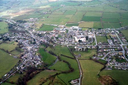
The small town of Tregaron is the only substantial settlement within the Ceredigion upland landscape. The historic core is centred on a market square and the medieval St Caron’s Church, with secondary development found on the west bank of the Brennig towards the former railway station. It is not a planned settlement, and most buildings front directly onto narrow, winding streets.
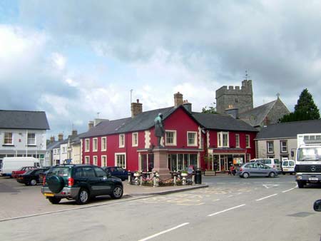
Stone is the principal traditional building material with slate for roofs. A variety of wall treatments are used including stucco, painted stone and bare stone. Apart from the parish church and a couple of small cottages (one listed), almost all the older buildings in Tregaron date to the 19th century. The Georgian Talbot Hotel and other, smaller commercial buildings are positioned on the market square. However, all these are relatively small and like the houses rarely rise above two storeys. Single build terraces and earlier cottages have strong vernacular traits, but larger and later houses have more Georgian elements. However, few have any architectural detailing apart from a few late 19th century detached villas. Some 19th century stone built farm outbuildings lend an agricultural feel to the centre of the town. The use of materials other than stone such as red- and yellow-brick for detailing and blue brick (in a terrace of houses) is evident on some late 19th and early 20th century houses. A 20th century hospital and secondary school lie on the fringes of the town along with a few early to mid 20th century houses, and many late 20th and 21st century houses.
Apart from buildings and monuments the only other recorded archaeology in this area comprises finds of Bronze Age date.
The urban development of Tregaron is very well defined - there is very little over-spill into the surrounding agricultural historic landscape areas.
Base map reproduced from the OS map with the permission
of Ordnance Survey on behalf of The Controller of Her Majesty's Stationery
Office, © Crown Copyright 2001.
All rights reserved. Unauthorised reproduction infringes Crown Copyright
and may lead to prosecution or civil proceedings. Licence Number: GD272221