Home > Historic Landscape Characterisation > Upland Ceredigion > |

 TRAWSCOED
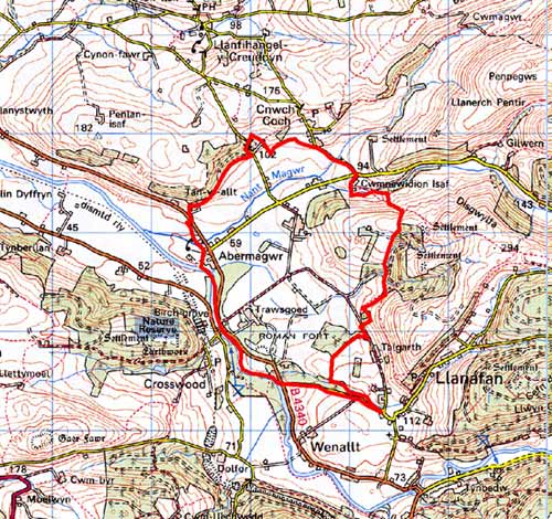
GRID REFERENCE: SN674735
AREA IN HECTARES: 363.6
Historic Background
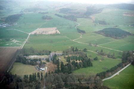
This area includes Crosswood (Trawscoed) mansion and most of what was Crosswood demesne. The story of the Vaughans of Crosswood begins in the 14th century when the daughter of Ieuan Coch married Adda Fychan, the direct ancestor of the present Lord Lisburne (Morgan 1997, 21). Throughout the latter Middle Ages the Vaughans served as minor officials and Crown agents, accumulating land and wealth. During the 16th and early 17th century judicious marriage and careful exchange and purchase resulted in the formation of a respectable-sized estate. This estate was dramatically expanded in 1630 with the purchase of many of the former granges of Strata Florida Abbey from the Earl of Essex. A fine mansion and gardens had been established at Crosswood by at least 1684 (Morgan 1997, 162). The house seems to have been entirely rebuilt by 1756. Remains of formal gardens depicted on estate maps (NLW Crosswood Vol 1, 4; NLW Map 7188, NLW Map 10127) have been examined and delineated from aerial photographs and described by Morgan (1997). The gardens are included on the Register of Landscapes, Parks and Gardens of Special Historic Interest in Wales. Part 1: Parks and Gardens; which contains a full description. In addition to the formal gardens, parkland was laid out and a deer park or paled park established. As with all parks of this scale considerable transformation occurred over the centuries. Former farms, such as Maesdwyffrwdd (NLW Crosswood Vol 1, 40), were demolished to make way for the park and land was subject to landscaping. A photograph of 1888 published by Morgan (1987, 21) shows the typical rolling grassland and scattered trees of a park created during the 18th century. Included in this area to the west of the park are dispersed farms. Estate maps show these in a landscape not dissimilar to that of today. In 1947, Crosswood was sold to the government, and the mansion converted to offices for the Ministry of Agriculture and Fisheries, and until 1995 was the Welsh headquarters of the Agricultural Advisory Service, and also part of the Institute for Grassland and Environmental Research (Morgan 1997, 172). Laboratory blocks and farm buildings of these institutions have been constructed in the former park, and a small housing estate built at Abermagwr.
Description and essential historic landscape components
This area lies on a terrace of the Afon Ystwyth at between 50 and 80m, and includes a rounded hill at its northeast limit, which achieves a height of 150m. The core of the area consists of Crosswood mansion and its associated gardens. The gardens are now much smaller than they once were, and a very large proportion of the parkland has been converted to improved pasture. All farmland is improved pasture. Several stands of trees, both broadleaf woodland and coniferous plantation, lend a wooded aspect to the landscape. Mature trees of the park and garden are also present. Government research institutions have transformed the area from that of parkland to one of intensive agricultural use. Older boundaries of earth banks with hedges - hedges are generally in good condition, but many require management - are now supplemented by wire fences, and these divide the area into large fields.
Settlement consists of estate buildings – the mansion, lodges etc – a loose cluster of dwellings at Abermagwr, and dispersed farms. Listed buildings – Trawscoed Mansion, model farm buildings, an Arts and Crafts lodge, gate pillars, a saw mill etc – reflect the strong estate influence across this landscape. Stone is the traditional building material, which is often left bare, with slate for roofs. Apart from the listed structures, buildings are either mid-to-late 19th century houses, including farmhouses, in the typical regional Georgian vernacular tradition, or modern. Farms have several ranges of stone outbuildings and modern agricultural buildings. Some modern outbuildings are, unusually for the region, in timber. Modern buildings are a prominent component of the landscape, and include mid to late 20th century houses, government offices and very large government agricultural buildings.
The major archaeological sites in this area consist of Trawscoed Roman fort and associated vicus, and the listed buildings and gardens of Crosswood mansion. The fort close to the mansion has been heavily ploughed and only below ground archaeological remains survives. Small areas have been investigated by archaeological excavation (Davies 1994, 300-302). Other archaeological sites include three cropmarks of unknown date and finds of Roman and Medieval date.
This historic landscape area is not particularly well defined. The overall character of areas to the north, south and east are not dissimilar, but they do not possess the estate components of this area. To the southeast definition is rather better as here land rises sharply up to unenclosed land.
Base map reproduced from the OS map with the permission
of Ordnance Survey on behalf of The Controller of Her Majesty's Stationery
Office, © Crown Copyright 2001.
All rights reserved. Unauthorised reproduction infringes Crown Copyright
and may lead to prosecution or civil proceedings. Licence Number: GD272221