Home > Historic Landscape Characterisation > Upland Ceredigion > |

 SUNNYHILL
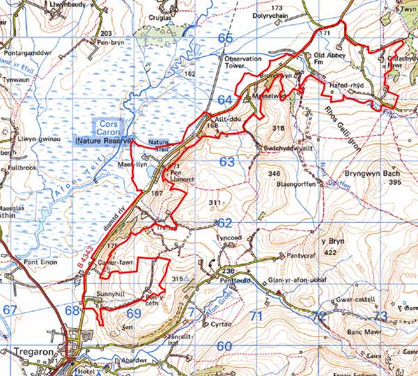
GRID REFERENCE: SN 692628
AREA IN HECTARES: 425.4
Historic Background
In the Medieval Period, a large part of this area lay within Strata Florida Abbey’s Pennardd Grange (Williams 1990, 56). There is a tradition that the original abbey site lay within this area at Yr Hen Fynachlog Farm (Radford 1971), and substantial foundations were uncovered here in the 19th century (Williams 1889). As with most of Strata Florida’s other granges it is likely that by the end of the Medieval Period, if not earlier, Pennardd was divided into many farms that were leased out and farmed on a commercial basis. Therefore, the settlement pattern of this area may by quite ancient. At the Dissolution, Strata Florida’s lands were granted to the Earl of Essex, while John Stedman acquired the demesne land. In 1630, the Vaughan family of Crosswood purchased much of the former grange land. In 1746, Stedman lands were passed to the Nanteos estate. Sunnyhill in the 18th century was the residence of the Powell family of Nanteos for several decades (Rees 1936, 61), and a former garden here is included on the Welsh Historic Gardens Database for Cardiganshire (RCAHMW, Welsh Historic Gardens Database). The layout of the garden is shown on an 1819 estate map. A water mill was recorded at Maes-llyn in 1682 (Rees 1936, 60). Historic map evidence (Caron Tithe Map and Apportionment, 1845; NLW Crosswood Vol, 1 8, 12, 14, 16, 20; NLW Crosswood Vol 2, 3; NLW Vol 45, 54; NLW Vol 36, 147) of the late 18th and early 19th centuries demonstrate that the modern landscape of this area had already been established by then. The settlement pattern, field systems and woodland areas have hardly changed since the compilation of these maps.
Description and essential historic landscape components
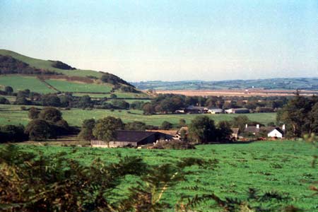
This area comprises a strip of flat ground on the east side of Cors Caron and the lower, northwest-facing valley sides. It lies between 165m and 200m. Agricultural land is now mostly improved pasture; though there are patches of rougher grazing and rushy ground in hollows close to Cors Caron. The overall characteristic is of small, irregular fields and dispersed farms with deciduous woodland on the steeper valley sides. Boundaries consist of earth banks with hedges. Hedges are generally in good condition and are stock-proof, though in the southern part of the area and on the higher slopes they are becoming derelict and have been replaced with wire fences.
The settlement pattern is of dispersed farms, which are relatively large for the region. Stone, left bare, cement rendered or painted is the traditional building material with slate for roofs. Two or three houses date to the late 18th or early 19th century and are firmly in the Georgian style. Others are smaller, but still two storey and in the typical later 19th century regional Georgian vernacular style - gable end chimneys, central front door, and two windows either side of the door and one above. Traditional 19th century farm buildings are also of stone. They are often substantial, indicating a large farm size, and include examples of several ranges of building, including barns, cow-houses, stables, cart houses etc, set formally or semi formally around a yard. Working farms have large ranges of modern agricultural buildings.
This area is within a route corridor. A disused railway line runs through the area from south to north. The present B4363 follows the eastern side of Cors Caron linking the medieval settlements and fairs of Pontryhdfendigaid, Ffair Rhos, Ystbyty Ystwyth and Machynlleth to the north with those of Tregaron, Llanddewi Breifi and Lampeter to the south.
The recorded archaeology mostly comprises sites of post-Medieval date and includes a chapel and Sunday school, as well as several dwellings and two minor metal mines. The possible former site of Strata Florida Abbey is included on the record as well as a documentary source to a Medieval settlement at Treflyn.
This area is well defined. Cors Caron lies to the west
and larger enclosures on higher ground to the east, with unenclosed land
in the northeast corner. Regular enclosures lie to the north. Only to
the south is there uncertainty where the exact boundary should be drawn
between this area and its neighbour.
Base map reproduced from the OS map with the permission
of Ordnance Survey on behalf of The Controller of Her Majesty's Stationery
Office, © Crown Copyright 2001.
All rights reserved. Unauthorised reproduction infringes Crown Copyright
and may lead to prosecution or civil proceedings. Licence Number: GD272221