Home > Historic Landscape Characterisation > Upland Ceredigion > |

 RHOS-Y-GELL
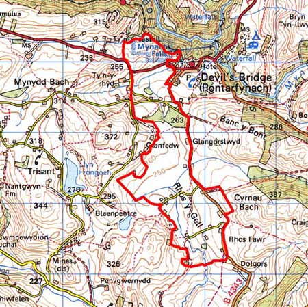
GRID REFERENCE: SN 735757
AREA IN HECTARES: 221.6
Historic Background
Historically, at least the eastern part of this area, if not all of it, lay within Strata Florida Abbey’s Cwmystwyth grange. The Crosswood estate purchased the granges of Strata Florida in 1630. Through a process of exchange, the former grange lands in this area became part of the Hafod estate in the late 18th century. The very poor quality of the land in this area ensured that it remained unenclosed until the relatively modern period. The tithe survey of 1847 (Llanfihangel-y-creuddyn) shows the area settled with a scatter of cottages and small enclosures. A Hafod estate map of 1834 shows cottages along the eastern limits of this area. Morgan (1997, 213) states these were squatter cottages and there is no reason to doubt this. They were probably built and the land enclosed in the late 18th and early 19th century. A schoolroom was built here in 1852 and a chapel was constructed 1872.
Description and essential historic landscape components
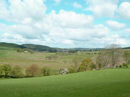
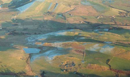
This wide, open valley - a wind gap between the deeply incised Ystwyth and Rheidol valleys - lying between 230 and 270m is characterised by a dispersed settlement pattern and poor quality grazing land. It is an area distinct from the surrounding areas of improved grazing, and consists of a field system of small, irregular enclosures containing rough grazing, peaty hollows and rushy ground with a few scattered patches of improved pasture. The field system is now becoming redundant; old-field boundaries of low banks are now almost entirely derelict. Hedges are overgrown and derelict. Wire fences now form the main stock proof barriers, which usually follow historic boundaries. Beech tree windbreaks have been planted, and small conifer plantations are present.
The settlement pattern is of dispersed cottages, smallholdings and small farms - 100-200m apart. Stone is the traditional building material. This is left bare on some of the farmhouses and some farm outbuildings and is generally cement rendered on smaller dwellings. Slate is the universal roofing material. The farmhouses are small and date to the mid to late 19th century and are in the typical Georgian vernacular style – two storey, gable end chimneys, central front door, and two windows either side of the door and one above. Most have strong Georgian traits rather than vernacular elements. The outbuildings of these farms are very small and often consist of just one range attached and in line to the house. Modern agricultural buildings where present are also small. The numerous cottages of this area are traditionally small, late 19th century and one, one-and-a-half or two storeys. Many have been extended and modernised, or recently rebuilt. There are numerous deserted cottages and farms scattered across the landscape.
The recorded archaeology mostly comprises abandoned cottages and smallholdings, but a metal mine and mill are also present, with time-depth to the landscape provided by a possible Bronze Age round barrow.
The limits of this area are well defined. To the west
and south lie areas of dispersed farms set in improved grazing with the
remains of lead mining. Unenclosed land lies to the east and Devil’s
Bridge (Pontarfynach) to the northeast. The steep-sided, wooded valley
of the Rheidol is situated to the north.
Base map reproduced from the OS map with the permission
of Ordnance Survey on behalf of The Controller of Her Majesty's Stationery
Office, © Crown Copyright 2001.
All rights reserved. Unauthorised reproduction infringes Crown Copyright
and may lead to prosecution or civil proceedings. Licence Number: GD272221