Home > Historic Landscape Characterisation > Upland Ceredigion > |

 PWLLPEIRAN
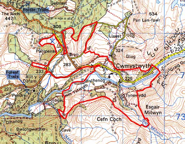
GRID REFERENCE: SN 783740
AREA IN HECTARES: 277.1
Historic Background
In the Medieval Period this area formed part of Strata Florida Abbey’s Cwmystwyth Grange (Williams 1990). By at least the later Middle Ages the grange had been divided into farms that were leased out and farmed on a commercial basis. A document of 1545-50 (Morgan 1991) records within this area the farms of Pwllpeiran and Milwyn. By 1590, the Herbert family had acquired most of the land in the area, and this land passed to the Johnes family in 1704. Thomas Johnes expanded his holdings in the late 18th century by exchange, in particular with land held by Crosswood, to build an estate that would compose most of the land in the area. Johnes was an enthusiastic land improver and developer of new farming techniques; undoubtedly some field boundaries and buildings are the result of his efforts. However, late 18th and early 19th century maps (NLW Crosswood Deeds No 5, Ser IV, Vol 1, 33, 35, 36, 73, 75; NLW R.M. A64) indicate that field and settlement patterns were very similar to that of today, allowing for the disappearance of some farms, the creation of others and the sub-division of some enclosures. When the settlement pattern and field system originated is uncertain, but they may be of Medieval date or earlier. Experiments in increasing the productivity of upland grazing were undertaken here in the 1930s (Colyer 1982, 100-3), and in the mid 1950s several farms were purchased by MAFF and the Forestry Commission with the aim of improving the hill economy; this resulted in 1955 in the establishment of the Pwllpeiran Experimental Husbandry Farm (Wildig 1994). The core of this farm lies in this area, though much of its upland grazing lies in neighbouring landscape areas. The farm has been responsible for much land improvement and the development of new techniques of planting and maintaining hedges. Peiran mill, belonging to the Medieval Grange of Cwmystwyth lies in this area. The mill continued in use until the late 18th century (Macve 1998). Trial levels for lead were dug in the mid 19th century, but these were unsuccessful (Bick 1974, 23). The natural route-way of the Ystwyth valley in which this area lies was emphasised in 1770 when a turnpike road was constructed. This road, the present B4574, provided the main connection between north Ceredigion and eastern Wales and England, until the completion of a new turnpike road through Ponterwyd in 1812 (Lewis 1955, 42-45). Included in this area is Cwmystwyth village, with its chapels and school. The history of the village is uncertain, but it is probably of 18th and 19th century origin, and was reliant on the metal mining industry.
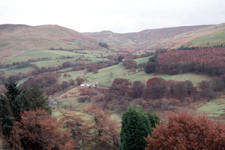
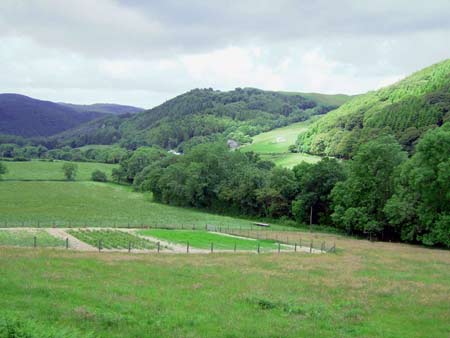
Description and essential historic landscape components
This large and complex area lies across the valley of the Ystwyth. It ranges in height from 180m on the valley floor to a maximum of 380m on the valley sides. Improved grazing land covers the majority of the farmed land, though rougher pasture is present at higher levels and on steep slopes. Fields are small and irregular. A variety of boundary types divide the fields. The most common type is the earth bank topped by hedges. Hedges on Pwllpeiran farm are generally well maintained, elsewhere their condition is variable; many are neglected and becoming overgrown - in some cases almost grown into tress - and on higher ground they have disappeared. Wire fences supplement most hedges. Dry-stone walls with capstones set at 45 degrees are also present - these are the work of Thomas Johnes - as are mortared walls alongside some roads. The dry-stone walls are in poor condition, but the mortared walls are in better condition. Small stands of broadleaf trees and small conifer plantations lie on valley sides. These together with the overgrown hedges lend a wooded appearance to parts of the area.
The settlement pattern is of dispersed farms and cottages, which includes Pwllpeiran Experimental Husbandry Farm with its complex of modern farm buildings and offices, plus a loose nucleation of industrial dwellings at Cwmystwyth. Older buildings probably date to the mid-to- late 19th century and are built of stone, which is cement rendered, left bare or painted on houses, and left bare on farm outbuildings. Houses are of two storeys in the regional Georgian vernacular style – gable end chimneys, central front door, and two windows either side of the door and one above. Some houses have strong vernacular traits whilst others are firmly in the Georgian tradition. An estate influence is detectable on some houses. Nineteenth century farm outbuildings are generally of two or three small ranges, but there are a couple or larger examples on some farms. Most working farms have small modern steel and concrete agricultural buildings, but there are a couple of examples of very large modern buildings. A lodge to the Hafod estate as well as other estate influenced buildings lie at Cwmystwyth. However, the main building type here is the worker house. These are either mid-to-late 19th century terraced vernacular cottages or are later 19th century houses in the Georgian vernacular style. There are several deserted cottages and houses in this landscape. Apart from Pwllpeiran farm, there is very little modern development.
Recorded archaeology is confined to metal mining remains and deserted cottages and farmsteads.
The boundaries of this area to the north where it edges forestry, and to the south and west against unenclosed land are well defined, but less so to the east where it merges with a squatter settlement. The core area of the Hafod estate to the southwest historically merged with this area, but its now heavily forested character provides a clear boundary line.
Base map reproduced from the OS map with the permission
of Ordnance Survey on behalf of The Controller of Her Majesty's Stationery
Office, © Crown Copyright 2001.
All rights reserved. Unauthorised reproduction infringes Crown Copyright
and may lead to prosecution or civil proceedings. Licence Number: GD272221