Home > Historic Landscape Characterisation > Upland Ceredigion > |

 PONTRHYDFENDIGAID
GRID REFERENCE: SN 730665
AREA IN HECTARES: 13.5
Historic Background
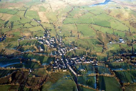
The history of this village has not been researched. In the Medieval Period, Pontrhydfendigaid lay within Strata Florida Abbey’s Mefenydd Grange. Williams (1990, 57) records a water mill and fulling mill. It is possible that these industries formed the focus of a small settlement. Upon the Dissolution the grange was granted to the Earl of Essex, and in 1630 the Vaughan family of Crosswood purchased it. The earliest large-scale map of the area is from the Crosswood collection of 1781 (NLW Crosswood Vol 2, 1), and shows linear development on both sides of a road, with some buildings added by a later hand. The impression from the map is of a developing settlement, which is supported by limited documentary sources - a chapel was constructed in 1794 (Percival 1998, 523). In the 19th century the village provided housing for workers in the local lead mining industry, and for those engaged in rural crafts: wool collecting, drying and preparation, hatting, basketry and candle manufacturing (Jones 1974, 72-80). Twentieth century development has included the construction of exhibition and sports facilities, and new housing.
Description and essential historic landscape components
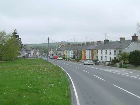
The village of Pontrhydfendigaid consists of 19th and 20th century linear development along either side of the B4343 and for a short distance on side roads. The bridge itself dates to the 18th century and is listed. A good example of a Georgian style chapel is also listed. Most older houses date to the mid–to-late 19th century. They are stone built - cement rendered, painted stone or left bare – with slate roofs. At least one early 19th century two storey vernacular cottage is present, but most houses are later and were probably built for various classes of workers in the lead mining industry. A variety of housing is represented, including terraces of two storey cottages in the vernacular tradition, late 19th century worker houses in the Georgian tradition, larger Georgian style terraced houses (some with architectural details such as porticos and door cases), and late 19th century villas. Two mid 19th century villas in the Georgian tradition detached from the village (but now connected by modern linear development) on the Strata Florida road were probably built for mine owners. Modern housing in small estates and individual houses or bungalows lie within and on the outskirts of the village. Sports facilities, steel frame agricultural buildings and exhibition halls have been constructed on the northern fringe of the village.
Apart from artefacts of prehistoric date, all recorded archaeology consists of buildings, rural craft and small industrial sites of post-Medieval date.
This is a well-defined area as it is surrounded by enclosed, agricultural land.
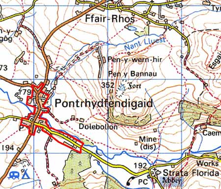
Base map reproduced from the OS map with the permission
of Ordnance Survey on behalf of The Controller of Her Majesty's Stationery
Office, © Crown Copyright 2001.
All rights reserved. Unauthorised reproduction infringes Crown Copyright
and may lead to prosecution or civil proceedings. Licence Number: GD272221