Home > Historic Landscape Characterisation > Upland Ceredigion > |

 PONTERWYD
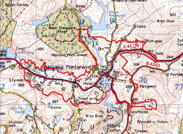
GRID REFERENCE: SN 750810
AREA IN HECTARES: 360.4
Historic Background
The western part of this area formed part of the Nantyrarian Grange belonging to Cwm-hir Abbey. The early history of the remainder has not been researched. By the 18th century, and probably earlier, the Nanteos and Gogerddan estates owned extensive tracts of land in and around Ponterwyd. Estate maps of the late 18th and early 19th (NLW Vol 45, 35; Vol 37, 51, 53) centuries demonstrate that this area has experienced considerable change over the last two centuries. Two hundred years ago, Ponterwyd itself consisted of a bridge and two dwellings, with one or two paddocks, within a large tract of unenclosed land. A similar pattern of settlement lay to the east of Ponterwyd - only a couple of dwellings, possibly squatter settlements, are shown on the maps. Bryn Bras and Troed-yr-Henriw are, however, possibly long established settlements, as these two farms are shown and named on the estate maps, each having small fields close to the dwellings with larger enclosures further out. To the north of the village and south of the present Dinas Reservoir lay a field system of small enclosures across the floor of the Rheidol valley. Although the area lay at the junction of an ancient east - west route corridor and a north – south route corridor and was the location of a fair (Lewis 1955, 45-47), it was the construction of a turnpike through Ponterwyd in 1812 (Colyer 1984, 176-82) that spurred the development of Ponterwyd village. A hotel was established - now named the George Borrow - a chapel constructed and houses built. Lead mining developed in the area. Works at Llywernog had been established by 1756 (Bick 1983, 12-18), but it was in the 19th century that the industry was fully developed, with the mines of Ponterwyd, Clara and Llywernog all working. These mines were amalgamated into the Llywernog United Silver-Lead Mining Co. in 1858, but production never seems to have been great, and working finally ceased in 1907. Llywernog is now a mining museum. The construction of the turnpike and the development of the mining industry promoted the growth of Ponterwyd and its surrounding area. Cottages, some still inhabited and some deserted, testify to the expansion of population in the 19th century. Coupled with this was an increase in the area of cultivated land, with much moorland subject to enclosure, and large fields sub-divided into smaller units. In the 1950s and early 1960s the construction of the Rheidol hydroelectric scheme led to a dramatic increase in population, resulting in much new housing in and around Ponterwyd.
Description and essential historic landscape components
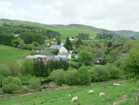
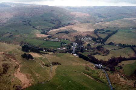
This complex area is centred on the village of Ponterwyd in the Rheidol valley. The river here flows in a narrow valley at approximately 200m, with the village and other settlements situated on a terrace at 230m. On slopes up to 310m lie higher farms and cottages. Scattered around the loosely nucleated village are dispersed farms and cottages set in a field system of medium-sized enclosures. These enclosures are formed from earth banks, and in a few instances, broken down dry-stone walls. The few hedges that are present are very overgrown, and are almost tree-size. Apart from these and small 20th century conifer plantations, this is generally a treeless landscape. Most earth banks have no hedges, and wire fences provide stock-proof barriers. Improved grazing dominates the area, but there is a large proportion of rough pasture, rushy ground and peaty hollows.
A late Georgian chapel and the Hen Bont, a late 18th
century bridge (both listed) lie at the heart of Ponterwyd village. Older
houses in the village consist of detached, semi-detached and terraced
19th century structures. The majority of these houses date to the mid-to-
late 19th century and are built of stone which is typically cement rendered
or painted on houses, and left bare on other buildings. Slate is the universal
roofing material, although an early photograph of an unidentified cottage
(Smith 1986, 286) near Ponterwyd shows that thatch was used as roofing
material up to the late 19th century. Houses are of two storeys in the
regional Georgian vernacular style – gable end chimneys, central
front door, and two windows either side of the door and one above. There
are two or three houses that date to the earlier 19th century and have
strong vernacular traits such as low eaves, an asymmetrical floor plan,
small windows and one chimney larger than the other. Later, larger detached
houses, probably of late 19th and early 20th century date were probably
built for mine supervisors or managers. There is a scattering of late
20th century houses and other buildings at Ponterwyd, as well as a small
20th century housing estate.
Rural buildings consist of dispersed farms, with farmhouses in the typical
regional Georgian style of the mid-to-late 19th century. Most farms have
two or three ranges of stone-built outbuildings; with working farms having
small to medium sized modern agricultural buildings. Other dispersed rural
buildings include the Georgian style George Borrow Hotel, 19th century
worker houses and a small chapel. There are numerous deserted cottages
and farms scattered across the landscape.
Remains of the lead mining industry are obvious and important components of the historic landscape. Spoil tips, reservoirs, leats and a collection of restored and reconstructed buildings at Llywernog mining museum are amongst some of the more important remains. Several of these buildings – gunpowder magazine, offices, ore dressing shed and rock crusher – are listed.
The recorded archaeology in this area is dominated by remains of the metal mining industry and by extant buildings such as chapels, a school and dwellings. Finds of Bronze Age date and a possible burnt mound of similar date provide the only time-depth to the landscape.
This is a well-defined area, with high moorland adjoining it on most sides, and to the north the reservoirs and dispersed farms of the upper Rheidol valley. Only to the south is there uncertainty as to where the boundary should be drawn.
Base map reproduced from the OS map with the permission
of Ordnance Survey on behalf of The Controller of Her Majesty's Stationery
Office, © Crown Copyright 2001.
All rights reserved. Unauthorised reproduction infringes Crown Copyright
and may lead to prosecution or civil proceedings. Licence Number: GD272221