Home > Historic Landscape Characterisation > Upland Ceredigion > |

 PONTARFYNACH
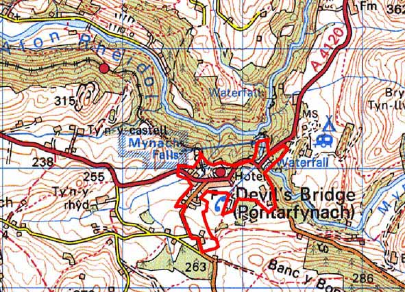
GRID REFERENCE: SN 739767
AREA IN HECTARES: 33.25
Historic Background
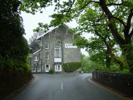
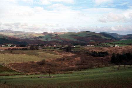
This small but complex landscape area lay within Strata Florida Abbey’s Cwmystwyth Grange in the Medieval Period. The grange, by at least the end of the Medieval Period, was divided into farms that were leased out. One such farm - Rhos-tyddyn - lay in this area (Morgan 1991). Upon the Dissolution of the abbey the farm along with others in the grange probably passed into the hands of the Herbert family, and eventually became part of Thomas Johnes’s Hafod estate. Though settlements such as Rhos-tyddyn Farm existed, it is likely that in the Medieval Period, and for centuries after, this area would have consisted of marginal land with woodland on the steeper slopes. It does, however, lie on an important north - south route-way, and includes the crossing point of the Mynach - Devil’s Bridge. The earliest phase of the surviving bridge may be of Medieval date. The importance of the route-way was emphasised in 1770 when Devil’s Bridge became the junction of two turnpike roads. From the west a turnpike ran up from Aberystwyth, over into Cwmystwyth and eventually to London. From Devil’s Bridge a second turnpike ran northwards to Shrewsbury (Lewis 1955, 41-45; Colyer, 1984, 176-182). A visit to the Mynach waterfalls and the Devil’s Bridge was a vital part of any tourist’s itinerary in the late 18th and 19th centuries; the presence of the turnpike roads ensured that these attractions were difficult to miss. Thomas Johnes constructed an inn to serve the tourist trade, and the extant building - the Hafod Arms Hotel - was later rebuilt in ‘Swiss Cottage’ style by the Duke of Newcastle (Walker 1998, 304), a subsequent owner of the Hafod estate. The garden of the Hafod Arms is recorded on the Welsh Historic Gardens Database. The vast numbers of paintings, drawings and engravings, published or unpublished, attest to the popularity of the falls in this period. A few houses and cottages developed close to the hotel, some perhaps for workers in the lead mining industry, but as the tithe map testifies the settlement in the 1840s was still very small. The Vale of Rheidol Railway, which opened in 1902, with its eastern terminus at Devil’s Bridge, was built to serve the leading mining industry, but rapidly became a tourist route. The railway and the continuing growth in the tourist industry has allowed Devil’s Bridge to develop into a small village with shops, a school and small-scale housing estates. Apart from the railway, industry in the area comprised a lead smelting works, which closed in 1834 (Bick 1983, 30), and a small hydroelectric scheme of the first half of the 20th century.
Description and essential historic landscape components
This area includes a sloping terrace at 200m - 250m on the south side of the Rheidol and that part of the Rheidol and Mynach valley sides which include the Mynach falls. Devil’s Bridge (Pontarfynach) village, located on the sloping terrace, is a straggling settlement centred on the imposing listed Hafod Arms Hotel and the listed ‘Devil’s Bridge’ itself. Most of the older houses in the village date to the mid-to-late 19th century and are built of stone, which is cement rendered or left bare. They are of two storeys in the regional Georgian vernacular style – gable end chimneys, central front door, and two windows either side of the door and one above. Some have strong Georgian elements rather than vernacular traits. Other older buildings include 19th century chapels, the single storey corrugated-iron station building of the Devil’s Bridge railway and several ‘temporary’ buildings such as ticket offices and cafes built to serve the mid 20th century tourist industry. These are distinctive and unusual elements of the landscape. Modern houses and bungalows have been constructed within and on the fringes of the village.
The village has been built over former enclosed, though poor quality land. Boundary banks of some of these enclosures are visible in non-developed areas. Some roadside boundaries, particularly close to the Hafod Arms Hotel, consist of mortared or dry-stone walls. Below the listed bridge is a complex series of paths and tracks leading to various viewing points for the falls. Though not examined in detail, it is possible that some of these paths date to the late 18th or early 19th century.
Apart from the celebrated bridge, the surviving structure of which may date back to the Medieval Period, the recorded archaeology comprises standing buildings or industrial remains.
To the south this area meets unenclosed land and to the
east the squatter settlement of Rhos-y-gell. To the north and east lie
the steep wooded slopes of the Rheidol and Mynach valleys.
Base map reproduced from the OS map with the permission
of Ordnance Survey on behalf of The Controller of Her Majesty's Stationery
Office, © Crown Copyright 2001.
All rights reserved. Unauthorised reproduction infringes Crown Copyright
and may lead to prosecution or civil proceedings. Licence Number: GD272221