Home > Historic Landscape Characterisation > Upland Ceredigion > |

 PEN-RHIW-NEWYDD
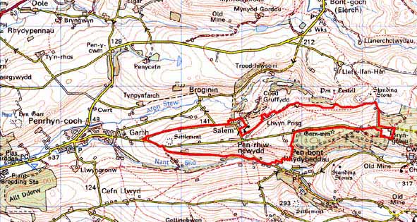
GRID REFERENCE: SN 674874
AREA IN HECTARES: 184.4
Historic Background
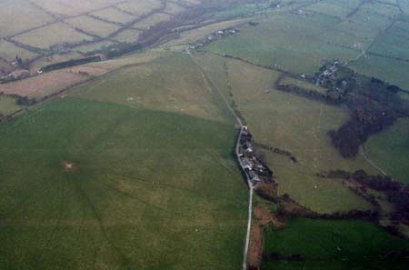
The early history of this area has not been researched. It may have been considered unenclosed Crown land for much of the early post-Medieval Period. By the late 18th century at least part of it had come into the possession of the Gogerddan estate. An estate map of 1788 (NLW R.M. 108) shows the ridge to the northeast of Tyn Gelli as enclosed into two large fields, with most of the remainder unenclosed apart from three ‘slangs’ alongside a public road. By the mid 19th century the whole area had been sub-divided into fields. Further sub-division took place in the second half of the 19th century. A chapel was established at Salem in 1824 (Percival 1998, 517), but no settlement developed here until after the tithe survey of 1845 (Llanbadarn tithe map and apportionment). Indeed, apart from Pantyffynnon Farm, all settlements in this area, including linear development at Salem and Pen-rhiw-newydd and isolated cottages, were established in the second half of the 19th century. The mechanism of these foundations is not certain. They may be squatter settlements, but a date in the second half of the 19th century is rather late, and they may have been, therefore, established as worker houses under the aegis of an estate or other landowner.
Description and essential historic landscape components
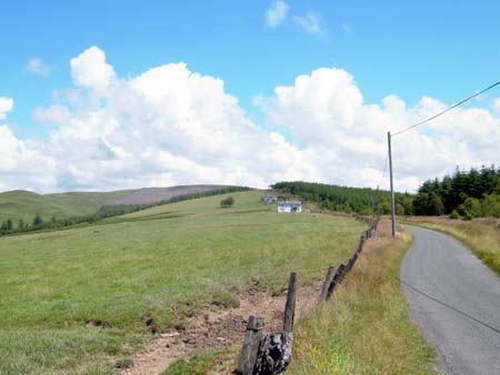
This area is an east - west rounded ridge, the crest of which descends from 320m in the east to less than 150m at its western end. The lower slopes of the ridge run down to below 120m. Low earth banks and occasional dry-stone walls divide the ridge into a field system of regular enclosures. No hedges survive on the ridge crest, and wire fences running along the old banks and walls provide stock-proof boundaries. On the lower slopes occasional semi-derelict hedges are present, and the earth banks are somewhat more substantial. It is essentially a treeless landscape. Improved grazing dominates, with some rougher ground on the steeper flanks of the ridge. A straight road runs along the ridge crest. The settlement pattern consists of dispersed cottages and houses, with 19th century loosely clustered linear development at Salem and Pen-rhiw-newydd. There is a particularly large mid 19th century rural chapel at Salem. Houses were probably originally built for industrial workers – there is little evidence that they have agricultural origins. Older houses are built of local stone (cement rendered or left bare), with slate (north Wales slate) used for roofs, and almost entirely date to the mid-to-late 19th century. They are relatively small, of two storeys, one-and-a-half storeys or one storey and in the typical Georgian vernacular style, with gable end chimneys, central front door, and two windows either side of the door and one above. They also display more dominant vernacular traits such as low eaves, small windows and one chimney larger than the other. Spaces between the older dwellings have been infilled by modern houses and bungalows.
The recorded archaeology comprises metal mining remains and a small Iron Age Fort. Ridge and furrow on the ridge crest is not dated, though may indicate agricultural use of the area prior to enclosure in the late 18th and early 19th centuries.
This is a well-defined area. To the north, south and west lies lower, enclosed land with extant hedges and stands of woodland. To the east is modern forestry.
Base map reproduced from the OS map with the permission
of Ordnance Survey on behalf of The Controller of Her Majesty's Stationery
Office, © Crown Copyright 2001.
All rights reserved. Unauthorised reproduction infringes Crown Copyright
and may lead to prosecution or civil proceedings. Licence Number: GD272221