Home > Historic Landscape Characterisation > Upland Ceredigion > |

 NANT COU AND NANT OCHRGARREG
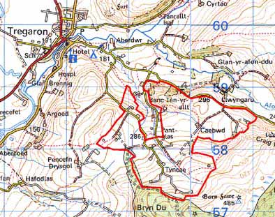
GRID REFERENCE: SN 697581
AREA IN HECTARES: 233.3
Historic background
The history of this area has not been researched. It is likely that in the early post-Medieval Period much of this area was unenclosed and therefore claimed by the Crown. It has only been colonised and enclosed over the past few centuries. The tithe map of 1845 (Caron Tithe Map and Apportionment) shows a landscape very different from that of today. Ochrgarreg, Caebwd, Troed-y-Rhiw and Cefn-y-Esgair Fawr and Fach farms were then in existence, each surrounded by a few small fields set within unenclosed ground. Glangors seems to have been a squatter settlement. Other farmsteads - Pant-Glas, Bryn-wernen, Tyncae - had not been founded. By 1887 when the Ordnance Survey (Ordnance Survey, 1891, 6” to 1 mile, Cardiganshire XXVII.NW) carried out their large-scale survey, the present settlement pattern and field system, apart from further subdivision of large enclosures, had been established. Thus, in common with many other similar areas of upland Ceredigion, the physical effects of population growth during the early 19th century are reflected in the landscape. Since then settlement has retreated.
Description and essential historic landscape components
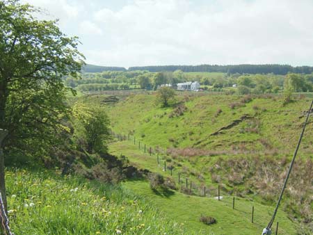
An area centred on the upper Nant Cou and Nant Ochrgarreg valleys between 290m and 400m. The topography is of undulating uplands with steep valley sides. Settlements are dispersed and set in a system of small, irregular fields. On the higher margins of the area these small fields give way to larger, more regular-shaped fields. Deciduous woodland is present on the steeper valley sides. Boundaries are of stone-faced banks topped with hedges, and occasional dry-stone walls. At lower levels hedges are in fair condition; at higher levels they are derelict. Most boundaries are now reinforced with wire fences. Boundaries on lower levels contain distinctive hedgerow trees. Agricultural land consists of improved pasture, with rough grazing and bracken on steep slopes and rushy ground with peaty deposits in hollows. There are considerable stands of deciduous woodland on the valley sides, and these, together with the hedgerow trees, give a moderately wooded aspect to the landscape.
Small farms characterise the settlement type. Local stone is the traditional building material with slate (north Wales slate) used for roofs. Walls are either cement rendered or left bare on houses, and bare on traditional farm buildings. Houses almost entirely date to the mid-to-late 19th century, are relatively small, of two storeys and in the typical Georgian vernacular style – gable end chimneys, central front door, and two windows either side of the door and one above. They also have strong vernacular traits such as low eaves, small windows and one chimney larger than the other. Many of the houses are modernised, and at least three modern houses or rebuilt houses are present. Stone-built farm outbuildings are generally confined to one or two small ranges, with several examples attached and in-line to the house. Several farms are not now working and their outbuildings are falling into disuse. Working farms have small ranges of modern steel and concrete agricultural buildings – these are not prominent landscape features.
The only recorded archaeological site in this area - finds of Bronze Age date - provides a limited time-depth element to the landscape.
To the north this area merges with its neighbouring area
and there is no distinct boundary. To the west the landscape area has
yet to be defined, though it is unenclosed land. Forestry plantation forms
a clear boundary to the south, and the eastern edge is clearly demarcated
where it meets unenclosed land.
Base map reproduced from the OS map with the permission
of Ordnance Survey on behalf of The Controller of Her Majesty's Stationery
Office, © Crown Copyright 2001.
All rights reserved. Unauthorised reproduction infringes Crown Copyright
and may lead to prosecution or civil proceedings. Licence Number: GD272221