Home > Historic Landscape Characterisation > Upland Ceredigion > |

 MYNYDD BACH - YSTWYTH VALLEY
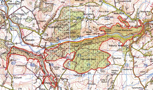
GRID REFERENCE: SN 696712
AREA IN HECTARES: 656.9
Historic Background
In the Medieval Period most of this area lay within Strata Florida Abbey’s Mefenydd Grange (Williams 1990, 57). In 1630 the Crosswood estate purchased most of the former granges of Strata Florida (Morgan 1987, 41), including, it would seem, part of this area, from Robert Devereux, Earl of Essex. From at least the late 18th century the steep valley sides of this area are heavily wooded (see estate maps NLW Crosswood Vol 1, 49, 55, 60 and the 1847 tithe map of Gwnnws parish), although the area known as Mynydd Bach was unenclosed sheep-walk or moorland up to the tithe survey, and therefore probably historically Crown land. Mynydd Bach was divided into a series of large enclosures in the second half of the 19th century. The whole area has now been subjected to afforestation. Planting began on the steep valley sides on land purchased from the Crosswood estate in the 1930s (Edlin 1959, 13), and later on the higher ground of Mynydd Bach. The Milford Manchester railway, opened in 1866 and closed in the 1960s, passed through this area.
Description and essential historic landscape components
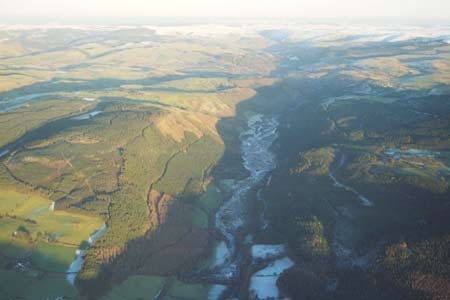
This landscape area encompasses the craggy hills of Mynydd Bach, which achieve a height of 370m, and the steep valley sides of the Ystwyth that fall to the river at 80m. The whole area is under woodland. At the extreme eastern end of the area close to Pontrhydygroes, and in the southwest near Tynygraig, small stands of deciduous trees survive, but elsewhere coniferous forests have either replaced the hardwoods or have been planted on former open land. Prior to afforestation, the steep slopes were cloaked with deciduous woods, and the high ground was rough grazing. Field boundaries from late 19th century enclosure lie within the forestry on Mynydd Bach, but were not examined for this survey. Remains of the lead mining industry lie on the northern fringes of this area, but the main components of the industry lie outside, and are therefore described elsewhere. Old railway embankments and cuttings are also industrial components of the landscape. Plantations, tracks, roads and other forestry features are the most common and prominent historic landscape components.
In addition to the industrial components of the landscape mentioned above, the recorded archaeology in the form of two Bronze Age round barrows provides time-depth to the landscape.
This is a very well-defined landscape area with the forestry bounded by semi-open moorland and improved grazing, or valley bottom, or settled and enclosed farmland.
Base map reproduced from the OS map with the permission
of Ordnance Survey on behalf of The Controller of Her Majesty's Stationery
Office, © Crown Copyright 2001.
All rights reserved. Unauthorised reproduction infringes Crown Copyright
and may lead to prosecution or civil proceedings. Licence Number: GD272221