Home > Historic Landscape Characterisation > Upland Ceredigion > |

 LLANFIHANGEL-Y-CREUDDYN
GRID REFERENCE: SN 668759
AREA IN HECTARES: 588.2
Historic Background
The history of this area has not been researched. Llanfihangel-y-Creuddyn was probably the administrative centre for Cwmwd Creuddyn in the Medieval Period. Rees (1932) records it as a trading centre, but not a borough. It is uncertain when a church was established here, but the dedication hints at a pre Anglo-Norman foundation. The current imposing cruciform church dates from mainly the Middle Ages - the 14th to 15th centuries (Ludlow 1998). Morgan (1997, 192) considers that Llanfihangel-y-Creuddyn was a bond vill of the Welsh lords of Creuddyn. If this is correct, then the implication is that there would have been a small, nucleated settlement surrounded by a strip- or open-field system. There are no map sources to support this, though compelling evidence comes from a document of 1743 quoted by Morgan (1997, 191) which refers to a slang of ground 131 by 11 yards in Pen-dre fields, and from physical elements of the landscape which are described below. In the 18th century Llanfihangel is occasionally referred to as a hamlet of half a dozen cottages. Assuming Morgan’s suggestion is correct, there is little evidence to indicate when the loose girdle of farms that surrounded the village were created, and when the modern field system was established. However, it is likely that by the end of the Medieval Period, with the acceptance in the concept of private ownership, farms held in severalty and small estates were being carved out of former strip fields. This was possibly the case at Llanfihangel where the small estate of Abertrinant (now a farm) was recorded in the early modern period. It is therefore to the 15th and 16th centuries that we must look to find the origins of the modern field system and dispersed settlement pattern. Estate maps of the 18th and early 19th century and the tithe map of 1847 show a landscape similar to that of today, with a nucleated settlement and dispersed farms set in a system of small fields.
Description and essential historic landscape characteristics
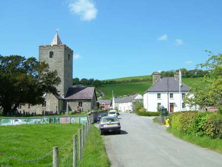
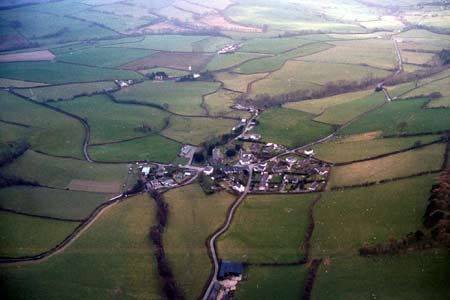
Centred on the village of Llanfihangel-y-Creuddyn, this area includes the floor and sides of the terminal of an open-sided valley. The valley floor lies at 80m and sides rise up to over 180m. It is a remarkably homogeneous area, consisting of small fields of improved pasture bounded by earth banks topped with hedges. There are small stands of deciduous woodland and conifer plantations. Improved pasture dominates, with virtually no rougher ground or arable. Hedges are generally in good condition and well maintained, though some are overgrown and becoming neglected. Wire fences supplement most hedge boundaries. The field patterning of long narrow fields, particularly close to the village, indicates that the present enclosed pattern could have evolved from an open- or strip-field system. The settlement pattern comprises the small nucleation of Llanfihangel-y-Creuddyn surrounded by a loose girdle of dispersed farms. The village retains much of its historic character. Local stone is the traditional building material, which is either left bare or cement rendered, although towards the end of the 19th century brick begins to be used on dwellings and farm outbuildings. The imposing listed cruciform St Michael’s church lies in the centre of the village and is surrounded by domestic buildings, including several that are listed. These include a cruck hall building probably dating to the 16th century, terraces of late 18th and early 19th century houses/cottages, a late Georgian house and a later 19th century gothic ‘villa’ with coach-house and stables. Other buildings include a small late 19th century school and an ever-increasing number of modern dwellings. A couple of small working farms are located in the village, but most are dispersed across the area. These mostly comprise mid to late 19th century houses in the typical Georgian vernacular style of the region, with one or two small ranges of stone outbuildings. Working farms have small to medium-sized modern agricultural buildings – these are not prominent components of the landscape.
The recorded archaeology of this area is mostly composed of standing buildings including a church, chapel, dwellings, two mills and a smithy. However, a cropmark enclosure indicates greater time-depth in the landscape, as it may be the ploughed-out remains of an Iron Age fort. Two place-names, Castell Cynon and Castell Banc-y-mor, may also indicate sites of Iron Age hillforts or other defensive sites.
Though this is a distinct character area, its boundaries
are not particularly well defined. To the south this area bounds the estate
landscape of Crosswood, to the west landscape areas have yet to be described,
and elsewhere it rises to higher, formerly unenclosed and less settled
land.
Base map reproduced from the OS map with the permission
of Ordnance Survey on behalf of The Controller of Her Majesty's Stationery
Office, © Crown Copyright 2001.
All rights reserved. Unauthorised reproduction infringes Crown Copyright
and may lead to prosecution or civil proceedings. Licence Number: GD272221